Hickison Petroglyph Recreation Area facts for kids
Quick facts for kids Hickison Petroglyph Recreation Area |
|
|---|---|

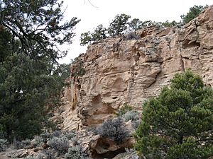
Cliff face along the self-guided trail
|
|
| Type | Public, Federal |
| Location | Lander County, Nevada, United States |
| Nearest city | Austin |
| Elevation | 6,500 feet (2,000 m) |
| Operated by | Bureau of Land Management |
| Open | Year-round |
The Hickison Petroglyph Recreation Area is a special place in Nevada. Here, you can see ancient rock carvings called petroglyphs. These amazing pictures were made by people who lived here long, long ago.
The area is found near Hickison Summit. It sits between the Toquima Range and the Simpson Park Mountains. The Bureau of Land Management takes care of this site. It's about 24 miles (39 km) east of Austin, right along U.S. Route 50. The site is high up, about 6,500 feet (2,000 m) above sea level. It's located on the western edge of the Monitor Valley, within the Great Basin.
This park offers a fun, self-guided tour. You can walk a 0.5-mile (0.8 km) trail to see many petroglyph panels. Along the way, you'll also see desert plants. You'll get great views of the Toquima and Toiyabe mountain ranges. The Big Smoky Valley is also visible. The park has 16 campsites for overnight stays. There's also a day-use area, toilets, and picnic spots. You'll find grills and trash cans, but remember to bring your own water!
Why is it Called Hickison?
Hickison Summit gets its name from a ranch owner. His name was John Hickerson. The road that leads to the old Hickerson ranch goes right over this summit. Sometimes, you might see the name spelled "Hickerson."
A Look Back in Time: History of Hickison
The area around Hickison Summit has a long history. People have lived and hunted here for a very long time. Some sites date back to 10,000 B.C.! Later, there were mining camps and ranches.
Famous explorers like John C. Frémont and James H. Simpson traveled through this area in the mid-1800s. The Pony Express also used routes here. The Overland Stage coaches passed through too.
Long ago, the Great Basin had huge lakes. These included Lake Toiyabe and Lake Tonopah. They were in the Big Smoky Valley, west of the summit. As the weather became drier, the lakes dried up. People who relied on the lakes changed their way of life. They became hunter-gatherers instead. When the first European-Americans arrived around 1850, Western Shoshone people lived in this region.
 | Percy Lavon Julian |
 | Katherine Johnson |
 | George Washington Carver |
 | Annie Easley |

