Highland Heights, Kentucky facts for kids
Quick facts for kids
Highland Heights, Kentucky
|
|
|---|---|

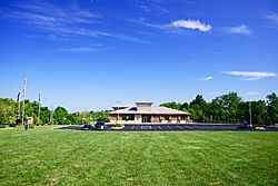
Municipal complex
|
|
| Motto(s):
"Growth Through Progress"
|
|

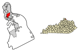
Location of Highland Heights in Campbell County, Kentucky.
|
|
| Country | United States |
| State | Kentucky |
| County | Campbell |
| Area | |
| • Total | 2.62 sq mi (6.79 km2) |
| • Land | 2.62 sq mi (6.79 km2) |
| • Water | 0.00 sq mi (0.00 km2) |
| Elevation | 843 ft (257 m) |
| Population
(2020)
|
|
| • Total | 6,662 |
| • Estimate
(2022)
|
6,418 |
| • Density | 2,542.75/sq mi (981.63/km2) |
| Time zone | UTC-5 (Eastern (EST)) |
| • Summer (DST) | UTC-4 (EDT) |
| ZIP codes |
41076, 41099
|
| Area code(s) | 859 |
| FIPS code | 21-36604 |
| GNIS feature ID | 2404699 |
Highland Heights is a city in Campbell County, Kentucky, United States. It is known as a "home rule-class city," which means it has the power to govern itself in many ways. In 2020, the city had a population of 6,662 people.
Highland Heights is home to Northern Kentucky University, a large college. It also hosts General Cable, a big company whose main office was built there in 1992. The city is part of the larger Cincinnati metropolitan area.
Contents
History of Highland Heights
The area where Highland Heights is located has been called "the Highlands" since the 1800s. A group called the District of the Highlands was officially formed in 1867. Later, in 1914, Fort Thomas became its own separate city from the northern part of the Highlands.
In 1927, a local post office was opened in the area. That same year, the community of Highland Heights officially became its own city.
Growth with Northern Kentucky University
In 1971, Northern Kentucky State College moved to a larger campus in Highland Heights. This college is now known as Northern Kentucky University (NKU). Because of the university, many new businesses and developments have grown in the city.
Geography of Highland Heights
Highland Heights is located in the northern part of Campbell County. It shares borders with other cities: Fort Thomas to the north, Wilder to the west, and Cold Spring to the south.
Major Roads and Location
Interstate 275, which is a major highway that goes around Cincinnati, runs along the western and northern edges of Highland Heights. The place where Interstate 275 connects with Interstate 471 is right at the northern border of Highland Heights. Using I-471, Highland Heights is about 7 miles (11 km) southeast of downtown Cincinnati.
The United States Census Bureau says that the city covers a total area of about 2.6 square miles (6.7 square kilometers), and all of it is land.
Population and People
| Historical population | |||
|---|---|---|---|
| Census | Pop. | %± | |
| 1930 | 625 | — | |
| 1940 | 855 | 36.8% | |
| 1950 | 1,569 | 83.5% | |
| 1960 | 3,491 | 122.5% | |
| 1970 | 4,543 | 30.1% | |
| 1980 | 4,435 | −2.4% | |
| 1990 | 4,223 | −4.8% | |
| 2000 | 5,153 | 22.0% | |
| 2010 | 6,923 | 34.3% | |
| 2020 | 6,662 | −3.8% | |
| 2022 (est.) | 6,418 | −7.3% | |
| U.S. Decennial Census | |||
According to the census from 2010, there were 6,923 people living in Highland Heights. The population density was about 2,882 people per square mile (1,113 people per square kilometer).
The median age of people in the city was 26.3 years old. About 13.6% of the population was under 18 years old.
Education in Highland Heights
Students who live in Highland Heights attend schools within the Campbell County School District. They are typically assigned to Campbell County High School, which is located in Alexandria.
Highland Heights is also home to the Japanese Language School of Greater Cincinnati. This is a special weekend school where students can learn Japanese. It has been held at Northern Kentucky University since July 1993.
See also
 In Spanish: Highland Heights (Kentucky) para niños
 | May Edward Chinn |
 | Rebecca Cole |
 | Alexa Canady |
 | Dorothy Lavinia Brown |

