Hillsboro, Georgia facts for kids
Quick facts for kids
Hillsboro, Georgia
|
|
|---|---|
| Country | United States |
| State | Georgia |
| County | Jasper |
| Elevation | 646 ft (197 m) |
| Time zone | UTC-5 (Eastern (EST)) |
| • Summer (DST) | UTC-4 (EDT) |
| ZIP code |
31038
|
| Area code(s) | 706 & 762 |
| GNIS feature ID | 356309 |
Hillsboro is a small community in Jasper County, Georgia, USA. It's called an "unincorporated community" because it doesn't have its own local government like a city or town. It was first settled a long time ago, around the year 1795.
Contents
Hillsboro: A Look at Its Past
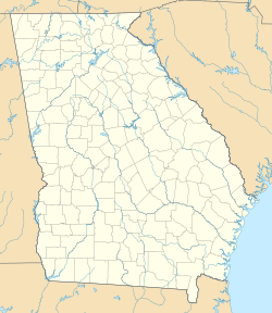
Hillsboro is located in the state of Georgia. You can find it about 9 miles (14.5 km) south of Monticello, which is the main town, or "county seat," of Jasper County. It sits along Georgia State Route 11, a road that used to be known as the "Macon to Athens Road."
How Hillsboro Began
The community of Hillsboro started around 1795. It was named after two early settlers, John and Isaac Hill. At first, its name was spelled "Hillsborough." For a short time in 1806, it was even the main town of Baldwin County. This was before Baldwin County was divided into Jasper and other counties. A famous person named Benjamin Harvey Hill was born here. He later became a senator for both the United States and the Confederate States.
Hillsboro During the Civil War
During the American Civil War, Hillsboro was in the path of a famous military campaign called Sherman's March to the Sea. Federal troops passed through, causing damage and taking supplies from the town. Later, the community was affected again when cavalry troops, led by Major General George Stoneman, marched through on their way to Macon. General Stoneman was later captured by the Confederate Army.
Hillsboro in the 20th Century
By the early 1900s, Hillsboro was a busy and successful community. It had many stores, churches, and shops. There was also a bank and a two-story school building. As the years went on, fewer students attended the school, and school districts combined. Because of this, the old school building was turned into a community center for everyone to use.
Hillsboro has its own post office with the ZIP code 31038.
 | George Robert Carruthers |
 | Patricia Bath |
 | Jan Ernst Matzeliger |
 | Alexander Miles |


