Hinsdale (CDP), New Hampshire facts for kids
Quick facts for kids
Hinsdale, New Hampshire
|
|
|---|---|

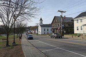
Main Street
|
|
| Country | United States |
| State | New Hampshire |
| County | Cheshire |
| Town | Hinsdale |
| Area | |
| • Total | 2.40 sq mi (6.21 km2) |
| • Land | 2.32 sq mi (6.02 km2) |
| • Water | 0.08 sq mi (0.20 km2) |
| Elevation | 250.7 ft (76.4 m) |
| Population
(2020)
|
|
| • Total | 1,485 |
| • Density | 639.26/sq mi (246.87/km2) |
| Time zone | UTC-5 (Eastern (EST)) |
| • Summer (DST) | UTC-4 (EDT) |
| ZIP code |
03451
|
| Area code(s) | 603 |
| FIPS code | 33-36580 |
| GNIS feature ID | 2378072 |
Hinsdale is a special area in New Hampshire, United States. It is known as a census-designated place (CDP). This means it's a specific area that the government uses to collect information about people. Hinsdale is the main village within the larger town of Hinsdale.
It is located in Cheshire County. In 2020, about 1,485 people lived in the Hinsdale CDP. The entire town of Hinsdale had a population of 3,948 people.
Contents
Where is Hinsdale Located?
Hinsdale CDP is in the southern part of the town of Hinsdale. To its west is the Connecticut River. To its east is the town of Winchester.
The Ashuelot River flows through the eastern and southern parts of Hinsdale. This river eventually joins the Connecticut River.
Main Roads and Travel
Several important roads pass through Hinsdale. New Hampshire Route 119 goes through the center of the village. It is known by different names like Brattleboro Road and Main Street. This route can take you east to Winchester, which is about 6 miles away. It also goes northwest to Brattleboro, Vermont, about 7 miles away.
Another road, New Hampshire Route 63, meets Route 119 on Main Street. Route 63 goes north about 8 miles to Chesterfield. It also goes south about 7 miles to Northfield, Massachusetts.
Land and Water Area
The Hinsdale CDP covers a total area of about 2.4 square miles (6.2 square kilometers). Most of this area is land, about 2.3 square miles (6.0 square kilometers). A smaller part, about 0.08 square miles (0.2 square kilometers), is water. This means about 3.2% of the area is water.
Who Lives in Hinsdale?
This section shares information about the people living in Hinsdale. This data comes from official counts, called a census.
Population Over Time
Here's how the population of Hinsdale CDP has changed over the years:
- 1950: 1,247 people
- 1960: 1,235 people
- 1970: 1,059 people
- 1980: 1,546 people
- 1990: 1,718 people
- 2000: 1,713 people
- 2010: 1,548 people
- 2020: 1,485 people
People and Households in 2010
In 2010, there were 1,548 people living in Hinsdale CDP. These people lived in 666 households. A household is a group of people living together in one home. Out of these, 393 were families.
Most people in Hinsdale were White (97.5%). A small number were from other backgrounds. About 1.2% of the population identified as Hispanic or Latino.
Families and Age Groups
In 2010, about 30.3% of households had children under 18 years old living there. Many households (42.0%) were headed by married couples. Some households (11.9%) had a female head with no husband present.
The average household had 2.32 people. The average family had 2.92 people.
The age of people in Hinsdale varied:
- 22.8% were under 18 years old.
- 8.5% were between 18 and 24 years old.
- 23.7% were between 25 and 44 years old.
- 29.8% were between 45 and 64 years old.
- 15.2% were 65 years old or older.
The average age of people in Hinsdale was 41.7 years.
See also
 In Spanish: Hinsdale (condado de Cheshire) para niños
 | Valerie Thomas |
 | Frederick McKinley Jones |
 | George Edward Alcorn Jr. |
 | Thomas Mensah |


