Winchester (CDP), New Hampshire facts for kids
Quick facts for kids
Winchester, New Hampshire
|
|
|---|---|

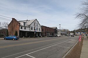
Main Street
|
|
| Country | United States |
| State | New Hampshire |
| County | Cheshire |
| Town | Winchester |
| Area | |
| • Total | 2.99 sq mi (7.73 km2) |
| • Land | 2.98 sq mi (7.71 km2) |
| • Water | 0.01 sq mi (0.02 km2) |
| Elevation | 443 ft (135 m) |
| Population
(2020)
|
|
| • Total | 1,606 |
| • Density | 539.29/sq mi (208.23/km2) |
| Time zone | UTC-5 (Eastern (EST)) |
| • Summer (DST) | UTC-4 (EDT) |
| ZIP code |
03470
|
| Area code(s) | 603 |
| FIPS code | 33-85460 |
| GNIS feature ID | 2378097 |
Winchester is a special area in the state of New Hampshire, United States. It's called a census-designated place (CDP). This means it's a part of the larger town of Winchester that the government counts separately for population.
Winchester is located in Cheshire County. In 2020, about 1,606 people lived in this special area. The whole town of Winchester has a larger population of about 4,150 people.
Contents
Where is Winchester Located?
Winchester is in the middle part of the town of Winchester. It sits on both sides of the Ashuelot River. This river eventually flows into the Connecticut River.
The northern edge of Winchester is near Clark Road and Spruce Lane. Its eastern side follows Forest Lake Road and goes along New Hampshire Route 119. The southern border follows small streams like Roaring Brook and Mirey Brook.
Main Roads in Winchester
New Hampshire Route 10 is the main road that goes through Winchester.
- It goes north about 13 miles (21 km) to Keene.
- It goes southwest about 7 miles (11 km) to Northfield, Massachusetts.
New Hampshire Route 119 also follows Route 10 for a bit.
- It goes east about 14 miles (23 km) to Fitzwilliam.
- It goes west about 6 miles (10 km) to Hinsdale.
Another road, New Hampshire Route 78, starts just south of Winchester.
- It goes south about 14 miles (23 km) to Orange, Massachusetts.
Land and Water Areas
Winchester covers about 2.99 square miles (7.7 square kilometers) of land. Only a very small part, about 0.01 square miles (0.02 square kilometers), is water.
Who Lives in Winchester?
The number of people living in Winchester has changed over the years.
| Historical population | |||
|---|---|---|---|
| Census | Pop. | %± | |
| 1980 | 1,732 | — | |
| 1990 | 1,735 | 0.2% | |
| 2000 | 1,832 | 5.6% | |
| 2010 | 1,733 | −5.4% | |
| 2020 | 1,606 | −7.3% | |
| U.S. Decennial Census | |||
In 2010, there were 1,733 people living in Winchester. They lived in 682 different homes. Most people were White (96.2%). A small number were from other backgrounds.
Families and Age Groups
About 35% of the homes in Winchester had children under 18 living there. Many homes were families with married parents. Some homes had a single parent.
The people living in Winchester in 2010 had different ages:
- About 25% were under 18 years old.
- About 10% were between 18 and 24 years old.
- About 26% were between 25 and 44 years old.
- About 27% were between 45 and 64 years old.
- About 13% were 65 years old or older.
The average age of people in Winchester was about 37 years old.
Income Information
From 2011 to 2015, the average yearly income for a household in Winchester was around $52,935. For families, it was about $54,596.
Some people in Winchester lived below the poverty line. This included about 18.5% of all people and 18.1% of families. About 27.6% of children under 18 and 20.1% of people 65 or older were also in this group.
See also

- In Spanish: Winchester (condado de Cheshire) para niños
 | Aurelia Browder |
 | Nannie Helen Burroughs |
 | Michelle Alexander |


