
History of Woolston, Southampton facts for kids
Woolston is a part of Southampton, a city in Hampshire, England. It has a long and interesting history, from Viking times to its important role in World War II. Let's explore the past of this area!
Contents
Woolston's Early Days
Woolston's name might come from "Olafs tun," which means "Olaf's fortified farm." This area was likely a strong base for the Vikings in the 10th century. A Viking leader named Olaf I of Norway is thought to have set up a camp here.
There's a small hill near modern-day Defender Road. This spot was perfect for the Vikings because it looked over Hamwic, an important Saxon port. In 994 AD, Vikings were known to be in the Itchen area, so this location would have been very useful for them.
How Woolston Got Its Name
In 1086, a very old book called the Domesday Book recorded the area as "Olvestune." But how did it become "Woolston"?
Southampton was a big trading port in the Middle Ages. A lot of wool from southern England was sent from here. There's even a building called the "Wool House" in Southampton today.
Wool from the countryside had to cross the River Itchen, Hampshire. The easiest way was by ferry from a nearby village called Itchen Ferry village. The next crossing was miles away! So, it's very likely that lots of wool was brought to this area to be ferried across the river. This important wool trade probably changed the name "Olvestune" into "Woolston."
People Who Lived in Woolston
Over the centuries, many important people owned land in Woolston.
In 1424, Richard Inkpen gave some land on the east side of the River Itchen to his daughter Alice. She was married to Richard Chamberlayne. Later, in the late 1700s, some of this land returned to the Chamberlayne family.
In 1536, a merchant from Genoa named Niccolo de Marini de Egra bought the Manor of Woolston. A "manor" was a large estate with a big house and land.
Later, in 1631, Sir George Rivers sold a huge amount of land (about 340 acres) and the rights to cross the Itchen River to Nathaniel Mills. This was likely the Woolston Manor. The owners of the Manors of Southampton and Woolston had the rights to the river crossing. But the fishermen of Itchen Ferry village actually ran the ferry and paid the Manor Lord for this privilege.
In 1781, William Chamberlayne inherited estates from Thomas Dummer at Woolston House. In 1802, William's son, also named William Chamberlayne (MP), created the Weston Grove Estate on land next to Woolston.
The Dummer/Chamberlayne family owned a very large area, stretching all the way to Netley. This included Netley Abbey. On January 3, 1856, Thomas Chamberlayne sold land that was used to build the Royal Victoria Military Hospital. Workers from Woolston helped build this huge hospital. The hospital then became a big customer for businesses in Woolston.
Woolston During Wartime
Woolston was a very important place during World War II. It had a major shipbuilding yard and the famous Supermarine factory nearby. This factory built the amazing Spitfire planes!
Because of these important factories, Woolston was bombed a lot by the German air force, the Luftwaffe. On September 26, 1940, the Supermarine factory and the nearby Itchen Ferry village were completely destroyed. But the bombing didn't stop the production of the Spitfire. The planes were secretly built in many different places across the country.
In 1943, the British Navy took over the bombed Supermarine factory. They used it as a base to plan PLUTO. This was a secret undersea pipeline that supplied fuel to the invasion forces after D-Day. This base was called HMS Abatos.
In August 1943, military rules were put in place for a "military exercise." This was a practice run for the invasion of Europe and D-Day in 1944. Parts of Woolston were specifically listed as areas that would be affected. The exercise, called Harlequin, tested how well the port of Southampton could load troops and equipment.
For the next nine months, Woolston saw a lot of military activity. It became part of a huge military camp in Hampshire, known as Area C. The ruins around Itchen Ferry village were even used to train soldiers for fighting in similar conditions in Europe.
Woolston was also in a "Regulated Area" starting in March 1944. This meant there were rules about people's movement in the final preparations for D-Day.
Other Interesting Facts About Woolston

In 1762, Walter Taylor built a special mill in what is now Mayfield Park. It used water power to cut wood.
Mayfield Park also has a monument to Charles James Fox, a famous politician. This tall stone monument, called an Obelisk, gave its name to a local street and a pub in Woolston.
Amelia Earhart, the first woman to fly solo across the Atlantic Ocean, landed in Woolston on June 19, 1928. What an exciting day that must have been!
The world's first international flying boat service started from Woolston in 1919. These planes could land on water, and they flew to Le Havre in France.
HMS Woolston (1918) was a British Navy ship built near the end of World War I. It helped protect other ships during World War II and was taken apart in 1947.
In 1928, Oliver Simmonds started the Simmonds Aircraft Co.Ltd. They built the Simmonds Spartan aircraft. The first one was built in his house in Woolston, and the first production model was put together in a building off Archery Road in Woolston.
Lost Streets and Buildings
Some parts of Woolston have changed a lot over time. Old maps from the late 1800s show areas called Woolston Lawn and Roselands. These were likely fancy areas. Roselands even had a fountain! The name Manor Road also suggests that a grand Manor House was once in this area.
Many of these old areas, including some buildings, were destroyed during World War II. Today, much of this land is covered by the Itchen Bridge, its toll booths, and control room.
An 1870 map shows Woolston House at the top of what is now St. Annes Road. It was right across from what is now the Conservative Club. The same map also shows the Woolston Coastguard Station in what is now Glen Road.
How Street Names Changed
When Woolston became part of Southampton in 1920, some streets had the same names as streets in other parts of Southampton. To avoid confusion, many street names in Woolston were changed in 1924.
For example, Bishops Road used to be High Street, and Florence Road was Alma Road. This is why you might find some interesting names, like Milton House on St. Annes Road, which used to be Milton Road!
Images for kids
-
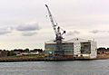
VTGroup Woolston In June 1904 John I. Thornycroft & Company moved to Woolston from Chiswick and bought the shipyard from Mordey Carney and Co.

