Hokota, Ibaraki facts for kids
Quick facts for kids
Hokota
鉾田市
|
|||||||||||||
|---|---|---|---|---|---|---|---|---|---|---|---|---|---|

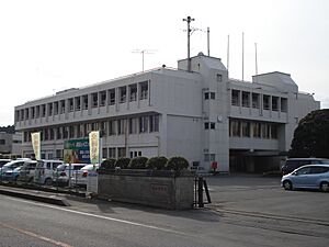
Hokota city hall
|
|||||||||||||
|
|||||||||||||

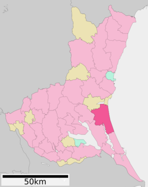
Location of Hokota in Ibaraki Prefecture
|
|||||||||||||
| Country | Japan | ||||||||||||
| Region | Kantō | ||||||||||||
| Prefecture | Ibaraki | ||||||||||||
| Area | |||||||||||||
| • Total | 207.61 km2 (80.16 sq mi) | ||||||||||||
| Population
(October 2020)
|
|||||||||||||
| • Total | 45,886 | ||||||||||||
| • Density | 221.020/km2 (572.440/sq mi) | ||||||||||||
| Time zone | UTC+9 (Japan Standard Time) | ||||||||||||
| Phone number | 0291-33-2111 | ||||||||||||
| Address | 1444-1 Hokota, Hokota-shi, Ibaraki-ken 311-1592 | ||||||||||||
| Climate | Cfa | ||||||||||||
|
|||||||||||||
Hokota (鉾田市, Hokota-shi) is a city located in Ibaraki Prefecture, Japan. In 2020, about 46,000 people lived in Hokota. The city covers an area of about 207.6 square kilometers (80.2 square miles).
Contents
Geography and Location
Hokota is in the central part of Ibaraki Prefecture. It is about 90 kilometers (56 miles) northeast of Tokyo. The city is also within 30 kilometers (19 miles) of Mito City, which is the capital of Ibaraki Prefecture.
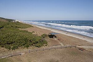
The eastern side of Hokota faces the Pacific Ocean. It has a long, flat coastline. Most of the land inside the city is also flat. This flat land and mild weather make farming the main industry here.
Neighboring Towns and Cities
Hokota shares its borders with several other places in Ibaraki Prefecture:
- Kashima
- Namegata
- Ōarai
- Omitama
Hokota's Climate
Hokota has a climate with warm summers and cold winters. There is usually light snowfall in winter. The average temperature for the year is about 13.8°C (56.8°F). October is the wettest month, with the most rainfall. The hottest month is August, with temperatures around 25.3°C (77.5°F). January is the coldest month, with temperatures around 2.8°C (37.0°F).
| Climate data for Hokota (1991−2020 normals, extremes 1978−present) | |||||||||||||
|---|---|---|---|---|---|---|---|---|---|---|---|---|---|
| Month | Jan | Feb | Mar | Apr | May | Jun | Jul | Aug | Sep | Oct | Nov | Dec | Year |
| Record high °C (°F) | 17.9 (64.2) |
24.2 (75.6) |
24.7 (76.5) |
29.4 (84.9) |
33.7 (92.7) |
34.4 (93.9) |
37.8 (100.0) |
37.8 (100.0) |
36.7 (98.1) |
32.5 (90.5) |
25.2 (77.4) |
24.1 (75.4) |
37.8 (100.0) |
| Mean daily maximum °C (°F) | 9.2 (48.6) |
9.6 (49.3) |
12.7 (54.9) |
17.6 (63.7) |
21.8 (71.2) |
24.3 (75.7) |
28.5 (83.3) |
30.0 (86.0) |
26.3 (79.3) |
21.2 (70.2) |
16.4 (61.5) |
11.5 (52.7) |
19.1 (66.4) |
| Daily mean °C (°F) | 2.8 (37.0) |
3.7 (38.7) |
7.1 (44.8) |
12.0 (53.6) |
16.6 (61.9) |
19.9 (67.8) |
23.8 (74.8) |
25.3 (77.5) |
21.9 (71.4) |
16.4 (61.5) |
10.6 (51.1) |
5.1 (41.2) |
13.8 (56.8) |
| Mean daily minimum °C (°F) | −3.0 (26.6) |
−2.2 (28.0) |
1.1 (34.0) |
6.2 (43.2) |
11.7 (53.1) |
16.2 (61.2) |
20.3 (68.5) |
21.8 (71.2) |
18.3 (64.9) |
11.9 (53.4) |
5.1 (41.2) |
−0.5 (31.1) |
8.9 (48.0) |
| Record low °C (°F) | −10.6 (12.9) |
−9.7 (14.5) |
−7.2 (19.0) |
−4.4 (24.1) |
−0.5 (31.1) |
7.3 (45.1) |
11.9 (53.4) |
12.6 (54.7) |
5.2 (41.4) |
−1.0 (30.2) |
−5.3 (22.5) |
−9.1 (15.6) |
−10.6 (12.9) |
| Average precipitation mm (inches) | 66.5 (2.62) |
62.9 (2.48) |
115.0 (4.53) |
122.5 (4.82) |
136.5 (5.37) |
141.9 (5.59) |
139.3 (5.48) |
101.8 (4.01) |
195.0 (7.68) |
230.7 (9.08) |
98.2 (3.87) |
58.3 (2.30) |
1,468.5 (57.81) |
| Average precipitation days (≥ 1.0 mm) | 5.8 | 6.1 | 9.9 | 10.8 | 10.9 | 11.8 | 11.2 | 7.9 | 10.8 | 11.0 | 7.9 | 5.9 | 110 |
| Mean monthly sunshine hours | 181.4 | 170.2 | 181.3 | 185.7 | 184.9 | 137.1 | 154.4 | 193.2 | 145.2 | 139.1 | 146.6 | 161.8 | 1,980.8 |
| Source: Japan Meteorological Agency | |||||||||||||
Population Changes Over Time
The number of people living in Hokota has stayed fairly steady for the past 70 years. Here's how the population has changed:
| Historical population | ||
|---|---|---|
| Year | Pop. | ±% |
| 1950 | 51,684 | — |
| 1960 | 50,616 | −2.1% |
| 1970 | 45,119 | −10.9% |
| 1980 | 47,731 | +5.8% |
| 1990 | 50,123 | +5.0% |
| 2000 | 50,915 | +1.6% |
| 2010 | 50,156 | −1.5% |
| 2020 | 45,953 | −8.4% |
History of Hokota
The town of Hokota was officially created on April 1, 1889. Later, on October 11, 2005, the city of Hokota was formed. This happened when the old town of Hokota merged with two nearby villages: Asahi and Taiyō.
Economy and Farming
The main way people in Hokota make a living is through farming. Melons are a very important crop grown here. They are a big part of the city's income.
Schools and Education
Hokota has many schools for young people.
- There are ten public elementary schools.
- There are five public middle schools.
- The city also has two public high schools.
Getting Around Hokota
Train Travel
![]() The Kashima Rinkai Railway's Ōarai Kashima Line runs through Hokota. You can catch a train at these stations:
The Kashima Rinkai Railway's Ōarai Kashima Line runs through Hokota. You can catch a train at these stations:
- Hinuma
- Kashima-Asahi
- Tokushuku
- Shin-Hokota
- Kitaurakohan
- Taiyō
Major Roads
Several important highways pass through Hokota, connecting it to other areas:
 National Route 51
 National Route 124
 National Route 354
Fun Places to Visit
If you visit Hokota, you might enjoy these spots:
- Kashima Littoral Park
- Otake Beach
Famous People from Hokota
- Tetsuya Asano is a well-known soccer player who comes from Hokota.
See also
 In Spanish: Hokota (Ibaraki) para niños
 | Bayard Rustin |
 | Jeannette Carter |
 | Jeremiah A. Brown |


