Hopland, California facts for kids
Quick facts for kids
Hopland
|
|
|---|---|

Downtown Hopland
|
|

Location in Mendocino County and California
|
|
| Country | |
| State | |
| County | Mendocino |
| Area | |
| • Total | 3.573 sq mi (9.25 km2) |
| • Land | 3.525 sq mi (9.13 km2) |
| • Water | 0.048 sq mi (0.12 km2) 1.35% |
| Elevation | 502 ft (153 m) |
| Population
(2020)
|
|
| • Total | 661 |
| • Density | 185.00/sq mi (71.43/km2) |
| Time zone | UTC-8 (Pacific) |
| • Summer (DST) | UTC-7 (PDT) |
| ZIP code |
95449
|
| Area code(s) | 707 |
| FIPS code | 06-34652 |
| GNIS feature IDs | 1658778; 2628739 |
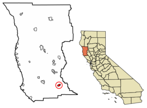
Hopland (once called Sanel) is a small community in Mendocino County, California, United States. It sits on the west side of the Russian River. Hopland is about 13 miles (21 km) south of Ukiah. It is located in the Sanel Valley and is about 502 feet (153 meters) above sea level. In 2020, 661 people lived there.
Hopland is at the start of California's North Coast region. It is about 100 miles (160 km) north of San Francisco. You can reach Clear Lake, California's largest natural lake, by driving about 30 minutes east. Hopland is a rural farming area surrounded by hills covered with oak trees. In summer, temperatures can get very hot, sometimes over 100°F (38°C).
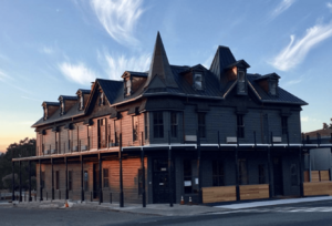
Some old buildings in Hopland are important to its history. These include the former Hopland High School, which was open from 1923 to 1965. The Thatcher Hotel, built in the late 1800s, has also been recently updated and reopened.
About 5 miles (8 km) east of Hopland is the University of California's Hopland Research and Extension Center. This large facility, covering 5,300 acres (21 km²), has been used for research and education since 1951.
Contents
Hopland's Location and Landscape
Hopland is in the southeastern part of Mendocino County. U.S. Route 101 runs through the town. This highway goes north to Ukiah, which is the main city of the county, about 14 miles (23 km) away. It also goes southeast to Santa Rosa, about 46 miles (74 km) away.
The United States Census Bureau says that Hopland covers about 3.6 square miles (9.3 km²). Most of this area is land, with a small part being water. The Russian River flows south along the eastern side of Hopland. The river separates the main part of Hopland from a smaller area called Old Hopland, which is also part of the community.
Weather in Hopland
Hopland has warm summers and mild, wet winters. Here is a quick look at the average weather:
| Month | High (°F) | Low (°F) | Precip. (inches) |
|---|---|---|---|
| January | 57 | 36 | 4.89 |
| February | 60 | 40 | 5.98 |
| March | 62 | 41 | 6.47 |
| April | 67 | 43 | 1.16 |
| May | 74 | 47 | 1.98 |
| June | 82 | 51 | 0.72 |
| July | 90 | 55 | 0.03 |
| August | 90 | 55 | 0.05 |
| September | 87 | 53 | 0.35 |
| October | 78 | 49 | 1.18 |
| November | 65 | 41 | 3.72 |
| December | 57 | 35 | 4.17 |
Hopland's History
The Pomo People
The Hopland Band of Pomo Indians, also known as the Sho-Ka-Wah, are Central Pomo people. They have lived in the Hopland area for a very long time. The Sho-Ka-Wah people hunted, gathered food, and practiced their traditions. Their main village, called "Shanel," once had about 1,500 people.
When settlers arrived, the Pomo people were forced to move from their homes. Today, most of the Sho-Ka-Wah people live on the Hopland reservation. This reservation is about 5 miles (8 km) east of Hopland. The community runs businesses to support its people. They also keep their spiritual and dance traditions alive and care for the land.
How Hopland Got Its Name
The area that became Hopland was first called "Sanel." Over the years, the town moved back and forth across the Russian River. Sanel started on the west side of the river in 1859. In 1874, the town moved to the east side to be closer to a new toll road.
When the railroad came to the west side of the river, the town moved back to its first spot. This left "Old Hopland" on the east bank. The Sanel post office opened in 1860. It changed its name to Hopland in 1879, then back to Sanel in 1890, and finally back to Hopland in 1891.
The town got its name because of "hops." From the 1870s to the mid-1950s, people in the area grew and dried a lot of bitter hops. Hops are a key ingredient used to flavor beer. This farming began in 1868. However, a plant disease called Downy mildew caused hop farming to stop completely by the late 1950s.
People of Hopland
| Historical population | |||
|---|---|---|---|
| Census | Pop. | %± | |
| 2010 | 756 | — | |
| 2020 | 661 | −12.6% | |
| U.S. Decennial Census | |||
In 2010, Hopland had a population of 756 people. By 2020, the population was 661. Most people in Hopland lived in family homes. A small number lived in group housing.
About 25.8% of the people were under 18 years old. About 7.5% were 65 years or older. The average age in Hopland was 34.6 years.
Many different groups of people live in Hopland. In 2010, about 68.9% of the people were White. About 5.0% were Native American. People of Hispanic or Latino background made up about 34.8% of the population.
See also
 In Spanish: Hopland para niños
 | Delilah Pierce |
 | Gordon Parks |
 | Augusta Savage |
 | Charles Ethan Porter |


