Hornick, Iowa facts for kids
Quick facts for kids
Hornick, Iowa
|
|
|---|---|
 |
|

Location of Hornick, Iowa
|
|
| Country | |
| State | |
| County | Woodbury |
| Incorporated | June 23, 1896 |
| Area | |
| • Total | 0.26 sq mi (0.66 km2) |
| • Land | 0.25 sq mi (0.65 km2) |
| • Water | 0.01 sq mi (0.01 km2) |
| Elevation | 1,063 ft (324 m) |
| Population
(2020)
|
|
| • Total | 255 |
| • Density | 1,015.94/sq mi (392.57/km2) |
| Time zone | UTC-6 (Central (CST)) |
| • Summer (DST) | UTC-5 (CDT) |
| ZIP code |
51026
|
| Area code(s) | 712 |
| FIPS code | 19-37200 |
| GNIS feature ID | 0457662 |
Hornick is a small city located in Woodbury County, Iowa, in the United States. It's part of the larger Sioux City area, which includes parts of Iowa, Nebraska, and South Dakota. In 2020, about 255 people lived in Hornick.
Contents
Where is Hornick?
Hornick is located in a special area near the Missouri River. It sits on a floodplain, which is flat land next to a river that can sometimes get covered by water. The city is also close to the Loess Hills, which are unique hills made of wind-blown soil.
The city covers a total area of about 0.26 square miles (0.67 square kilometers). Most of this area is land, with a very small part being water.
A Look at Hornick's History
Hornick has faced challenges, especially with floods. In 2019, the city was hit by floods that left parts of it under two feet of water. To help prevent future flooding, plans are in place to build a protective wall called a berm. This is similar to a temporary berm that helped protect the town in 1996.
In the past, Hornick had a train station that offered passenger service. This station, called Hornick station, is now listed on the National Register of Historic Places (NRHP) because of its historical importance.
Who Lives in Hornick?
| Historical populations | ||
|---|---|---|
| Year | Pop. | ±% |
| 1900 | 284 | — |
| 1910 | 245 | −13.7% |
| 1920 | 296 | +20.8% |
| 1930 | 309 | +4.4% |
| 1940 | 291 | −5.8% |
| 1950 | 310 | +6.5% |
| 1960 | 275 | −11.3% |
| 1970 | 250 | −9.1% |
| 1980 | 239 | −4.4% |
| 1990 | 222 | −7.1% |
| 2000 | 253 | +14.0% |
| 2010 | 225 | −11.1% |
| 2020 | 255 | +13.3% |
| Source: and Iowa Data Center Source: |
||
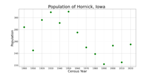
The population of Hornick changes over time, as shown in the table and graph. In 2020, there were 255 people living in the city.
Hornick's Households
In 2020, there were 94 households in Hornick. A household is a group of people living together in one home. Many households included families, with about 40% having children under 18 years old. About half of the households were married couples living together.
Age and Gender in Hornick
The median age in Hornick in 2020 was about 35.4 years old. This means half the people were younger than 35.4 and half were older.
- About 31% of residents were under 20 years old.
- About 29% were between 25 and 44 years old.
- About 13% were 65 years old or older.
The city's population was almost evenly split between males and females, with 51.4% male and 48.6% female residents.
See also
 In Spanish: Hornick (Iowa) para niños
 | Jackie Robinson |
 | Jack Johnson |
 | Althea Gibson |
 | Arthur Ashe |
 | Muhammad Ali |


