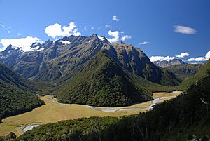
Humboldt Mountains (New Zealand) facts for kids
The Humboldt Mountains, also known as the Humboldt Range, are a group of mountains in the South Island of New Zealand. They are part of the larger Southern Alps mountain chain. These mountains are located northwest of Lake Wakatipu in the Otago Region.
A big part of the Humboldt Mountains is inside Fiordland National Park. They also make up the southern edge of Mount Aspiring National Park. An early explorer named James McKerrow gave the mountains their name. He named them after a famous scientist, Alexander von Humboldt. Many places around the world are named after him!
Where are the Humboldt Mountains?
The Humboldt Mountains stretch for about 30 kilometers (19 miles) from north to south. On their eastern and western sides, you'll find long valleys. These valleys were carved out by glaciers a long time ago. The Hollyford River runs along one side. The Dart River runs along the other.
To the south, a smaller valley with the Caples River separates the Humboldts from the Ailsa Range. In the very southeast, the mountains drop right down to the clear waters of Lake Wakatipu. Close by are the small towns of Kinloch and Glenorchy.
Rivers and Peaks
Many small rivers start high up in the Humboldt Mountains. Two important ones are the Routeburn River and the Olivine River.
Several peaks in the Humboldt Mountains are very tall. They rise over 2,000 meters (6,560 feet) above sea level. The highest point is Mount Bonpland. It stands at an impressive 2,348 meters (7,703 feet) tall.
Exploring the Humboldts
The Humboldt Mountains are a popular place for outdoor adventures. Two well-known tramping tracks go through the valleys here. These are the Caples Track and the famous Routeburn Track. These tracks let people explore the beautiful scenery and enjoy nature.
 | Audre Lorde |
 | John Berry Meachum |
 | Ferdinand Lee Barnett |


