Hundred of Munno Para facts for kids
Quick facts for kids Munno ParaSouth Australia |
|||||||||||||||
|---|---|---|---|---|---|---|---|---|---|---|---|---|---|---|---|

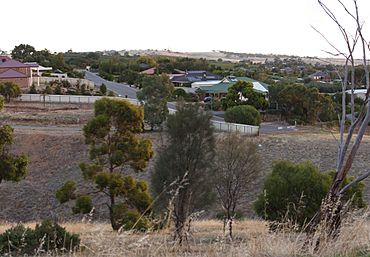
View of Adelaide foothills, Craigmore
|
|||||||||||||||
| Established | 29 October 1846 | ||||||||||||||
| County | Adelaide | ||||||||||||||
|
|||||||||||||||
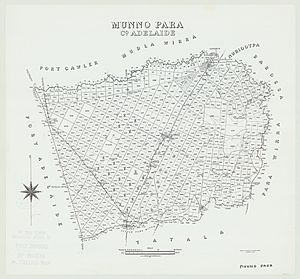
The Hundred of Munno Para is a special area of land in South Australia. It covers the northern suburbs of Adelaide, just north of the Little Para River. It also includes some nearby rural areas. A "hundred" is an old way of dividing land. It was used for things like taxes and local government.
Munno Para is one of eleven hundreds in the County of Adelaide. It was named in 1846 by Governor Frederick Robe. The name "Munno Para" comes from the local Kaurna people. It means golden wattle creek. This name might refer to the Gawler River or the Little Para River. The Gawler River starts where the South Para River and North Para River join together.
Contents
History of Munno Para
This section explains how the area of Munno Para grew and changed over time. It covers how local councils were formed and merged.
Early Local Government
In the past, local areas needed their own rules and services. This is called local government. The District Council of Munno Para East and District Council of Munno Para West were set up in 1853 and 1854. These councils helped manage the whole hundred.
Over time, these councils changed. In 1899, a part of Munno Para West became the District Council of Gawler South. This new council later joined with the Corporate Town of Gawler in 1933. The rest of Munno Para West council also ended that year.
Forming the New Munno Para Council
Some parts of the old Munno Para West council joined the Gawler area. Other parts went to a new council called the District Council of Salisbury. The remaining parts of Munno Para West joined with Munno Para East. This created the new District Council of Munno Para.
This new council covered almost the entire hundred. Only small parts were managed by Salisbury in the southwest and Gawler in the northeast. The main office for the Munno Para council was in Smithfield. This town is in the middle of the hundred, right next to the main road north.
Growth and New Towns
After World War II, many people moved to the area. The town of Elizabeth was built within the hundred. It was created to house workers for a new car factory, Holden. Elizabeth was located between Smithfield and Salisbury.
At first, Elizabeth was part of the Salisbury council area. But in 1964, it became its own council, called the Town of Elizabeth. Salisbury also became a city that same year. In 1988, the Munno Para council also became a city.
Modern Councils in Munno Para
In 1997, the cities of Munno Para and Elizabeth joined together. They formed the City of Playford. This new city is just north of Salisbury.
Today, several local government areas manage parts of the Munno Para hundred. The City of Playford covers most of it. The City of Salisbury manages the southwest corner. This includes the RAAF Edinburgh air force base. The Town of Gawler is in the northeast corner. It surrounds the Gawler township.
 | Mary Eliza Mahoney |
 | Susie King Taylor |
 | Ida Gray |
 | Eliza Ann Grier |


