
Hungry Run (South Branch French Creek tributary) facts for kids
Quick facts for kids Hungry Run |
|
|---|---|


Location of Hungry Run mouth
|
|
| Other name(s) | Tributary to South Branch French Creek |
| Country | United States |
| State | Pennsylvania |
| Counties | Erie Crawford |
| Physical characteristics | |
| Main source | divide between Hungry Run and Britton Run (Oil Creek) about 3 miles northeast of Tillotson, Pennsylvania 1,645 ft (501 m) 41°50′36″N 079°46′40″W / 41.84333°N 79.77778°W |
| River mouth | South Branch French Creek about 2 miles southwest of Elgin, Pennsylvania 1,319 ft (402 m) 41°53′07″N 079°46′41″W / 41.88528°N 79.77806°W |
| Length | 3.49 mi (5.62 km) |
| Basin features | |
| Progression | north |
| River system | Allegheny River |
| Basin size | 4.47 square miles (11.6 km2) |
| Tributaries |
|
| Bridges | Hungry Run Road (x2), Concord Road |
Hungry Run is a small stream, about 3.49 mi (5.62 km) long, located in Pennsylvania, United States. It flows into another stream called South Branch French Creek. Scientists classify Hungry Run as a "2nd order stream." This means it's formed when two smaller streams (1st order) join together.
Where Does Hungry Run Flow?
Hungry Run begins in Bloomfield Township, which is in the northern part of Crawford County. From there, it travels north.
The stream then crosses into Erie County. It flows through Union Township before finally meeting up with South Branch French Creek.
Understanding the Watershed
A watershed is like a giant bowl that collects all the rain and snowmelt in an area, directing it towards a single stream or river. The Hungry Run watershed covers about 4.47 square miles (11.6 km2). This area is part of something called the Erie Drift Plain, which is a type of land shaped by ancient glaciers.
On average, the Hungry Run watershed gets about 46.6 inches of rain and snow every year. It also has a "wetness index" of 469.09, which helps scientists understand how much water the land holds.
Images for kids
-
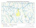
This map shows the path of Hungry Run.
-
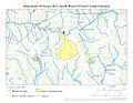
This map illustrates the watershed area of Hungry Run, showing where its water comes from.
.jpg)
.jpg)
