kids encyclopedia robot

South Branch French Creek (French Creek tributary) facts for kids

Kids Encyclopedia Facts
Quick facts for kids
South Branch French Creek
Photocopy of photograph, date unknown. VIEW OF WEST HIGH STREET BRIDGE OVER SOUTH BRANCH OF FRENCH CREEK, WITH PENN RAILROAD BRIDGE IN BACKGROUND. (Original in Union City HAER PA,25-UNCI,2-7.tif
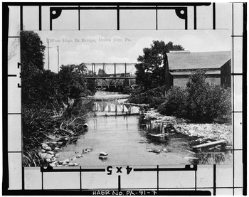
View of West High Street Bridge over South Branch of French Creek, with Penn Railroad Bridge in background
South Branch French Creek (French Creek tributary) is located in Pennsylvania
South Branch French Creek (French Creek tributary)
South Branch French Creek (French Creek tributary) is located in the United States
South Branch French Creek (French Creek tributary)
Location of the mouth of South Branch French Creek
Other name(s) Tributary to French Creek
Country United States
State Pennsylvania
County Erie
Physical characteristics
Main source divide between East Branch Oil Creek and Spring Creek
Southeastern corner of Erie County, about 2 miles northeast of Spartansburg, Pennsylvania
1,680 ft (510 m)
41°51′50″N 079°38′42″W / 41.86389°N 79.64500°W / 41.86389; -79.64500
River mouth French Creek
about 1.5 miles west of Union City, Pennsylvania
1,200 ft (370 m)
41°54′10″N 079°54′06″W / 41.90278°N 79.90167°W / 41.90278; -79.90167
Length 24.2 mi (38.9 km)
Basin features
Progression west
River system Allegheny River
Basin size 81.3 square miles (211 km2)
Population 5,059 (2010)
Tributaries

South Branch French Creek is a 24.2-mile (38.9 km) long tributary to French Creek in Erie County, Pennsylvania. It is classed as a 3rd order stream on the EPA waters geoviewer site.

Course

South Branch French Creek rises in Concord Township of southeastern Erie County, Pennsylvania and flows south towards Corry, Pennsylvania then turns west towards Union City, Pennsylvania. Many tributaries feed into it on its way to French Creek west of Union City.

Watershed

South Branch French Creek drains 81.3 square miles of Erie Drift Plain (glacial geology). The watershed receives an average of 47.7 in/year of precipitation and has a wetness index of 457.08.

Tributaries

Tributaries to South Branch French Creek (French Creek tributary)
Name, Bank River Mile (km) Watershed Area in Square Miles (km2) Average Discharge Mouth Coordinates Mouth Elevation Source Coordinates Source Elevation Remarks
Mouth 81.3 square miles (211 km2) 151.52 cu ft/s (4.291 m3/s) 41°54′10″N 079°54′06″W / 41.90278°N 79.90167°W / 41.90278; -79.90167 1,200 ft (370 m) 41°51′50″N 79°38′42″W / 41.86389°N 79.64500°W / 41.86389; -79.64500 1,680 ft (510 m) South Branch French Creek rises in Concord Township, Erie County, Pennsylvania and flows through the boroughs of Corry and Union City to join French Creek west of Union City.
Horton Run, left bank 0.88 mi (1.42 km) 3.11 square miles (8.1 km2) 6.22 cu ft/s (0.176 m3/s) 41°54′11″N 079°53′13″W / 41.90306°N 79.88694°W / 41.90306; -79.88694 1,204 ft (367 m) 41°51′36″N 079°50′56″W / 41.86000°N 79.84889°W / 41.86000; -79.84889 1,550 ft (470 m) Horton Run rises about 2.5 miles southeast of Hinkley Corners, Pennsylvania on the divide between it and West Shreve Run (Oil Creek). It then flows northwest to join South Branch French Creek about 1 mile west of Union City, Pennsylvania.
Bentley Run, right bank 4.30 mi (6.92 km) 4.10 square miles (10.6 km2) 8.09 cu ft/s (0.229 m3/s) 41°53′50″N 079°50′12″W / 41.89722°N 79.83667°W / 41.89722; -79.83667 1,266 ft (386 m) 41°55′51″N 079°47′39″W / 41.93083°N 79.79417°W / 41.93083; -79.79417 1,520 ft (460 m) Bentley Run rises just upstream of Union City Reservoir, about 1 mile north of Union City on the divide between it, Alder Run and Pine Run. The stream then flows southwest to meet South Branch French Creek in Union City, Pennsylvania.
Pine Run, right bank 8.96 mi (14.42 km) 2.0 square miles (5.2 km2) 5.45 cu ft/s (0.154 m3/s) 41°53′33″N 079°47′07″W / 41.89250°N 79.78528°W / 41.89250; -79.78528 1,309 ft (399 m) 41°56′07″N 079°47′29″W / 41.93528°N 79.79139°W / 41.93528; -79.79139 1,580 ft (480 m) Pine Run rises on the divide between Bentley Run and Beaver Run, about 2 miles northeast of Union City, Pennsylvania. The stream then flows south to meet South Branch French Creek east of Union City.
Hungry Run, left bank 10.10 mi (16.25 km) 4.47 square miles (11.6 km2) 9.00 cu ft/s (0.255 m3/s) 41°53′07″N 079°46′41″W / 41.88528°N 79.77806°W / 41.88528; -79.77806 1,319 ft (402 m) 41°50′36″N 079°46′40″W / 41.84333°N 79.77778°W / 41.84333; -79.77778 1,550 ft (470 m) Hungry Run rises on the Britton Run divide about 3 northeast of Tillotson, Pennsylvania. The stream then flows north to meet South Branch French Creek about 2 miles southwest of Elgin, Pennsylvania.
Lilley Run, left bank 13.20 mi (21.24 km) 4.77 square miles (12.4 km2) 9.73 cu ft/s (0.276 m3/s) 41°53′26″N 079°44′32″W / 41.89056°N 79.74222°W / 41.89056; -79.74222 1,342 ft (409 m) 41°50′55″N 079°43′46″W / 41.84861°N 79.72944°W / 41.84861; -79.72944 1,652 ft (504 m) Lilley Run rises in a pond on the divide between this stream and Stranahan Run. Lilley Run then flows north to meet South Branch French Creek about 0.5 miles west of Concord, Pennsylvania.
Beaver Run, right bank 13.42 mi (21.60 km) 6.87 square miles (17.8 km2) 13.55 cu ft/s (0.384 m3/s) 41°53′27″N 079°44′22″W / 41.89083°N 79.73944°W / 41.89083; -79.73944 1,342 ft (409 m) 41°56′35″N 079°47′25″W / 41.94306°N 79.79028°W / 41.94306; -79.79028 1,505 ft (459 m) Beaver Run rises about 3 miles northwest of Beaver Dam, Pennsylvania on the Bentley Run divide. The stream then flows south to meet South Branch French Creek about 0.5 miles south of Elgin, Pennsylvania.
Slaughter Run, right bank 15.24 mi (24.53 km) 5.67 square miles (14.7 km2) 11.47 cu ft/s (0.325 m3/s) 41°54′06″N 079°43′08″W / 41.90167°N 79.71889°W / 41.90167; -79.71889 1,352 ft (412 m) 41°56′58″N 079°44′28″W / 41.94944°N 79.74111°W / 41.94944; -79.74111 1,790 ft (550 m) Slaughter Run rises on the Herrick Creek divide about 2 miles northwest of Five Points, Pennsylvania. The stream then flows south to meet South Branch French Creek about 1 mile east of Elgin, Pennsylvania.
Baskin Run, right bank 15.86 mi (25.52 km) 4.86 square miles (12.6 km2) 10.21 cu ft/s (0.289 m3/s) 41°54′23″N 079°42′42″W / 41.90639°N 79.71167°W / 41.90639; -79.71167 1,358 ft (414 m) 41°58′48″N 079°43′10″W / 41.98000°N 79.71944°W / 41.98000; -79.71944 1,832 ft (558 m) Baskin Run rises on the Hare Creek divide about 0.5 miles northwest of Five Points, Pennsylvania. The stream then flows south to meet South Branch French Creek about 0.25 miles west of Lovell, Pennsylvania.
Spencer Creek, right bank 18.52 mi (29.81 km) 3.38 square miles (8.8 km2) 7.24 cu ft/s (0.205 m3/s) 41°55′09″N 079°41′00″W / 41.91917°N 79.68333°W / 41.91917; -79.68333 1,371 ft (418 m) 41°58′08″N 079°41′21″W / 41.96889°N 79.68917°W / 41.96889; -79.68917 1,820 ft (550 m) Spencer Creek rises on the Hare Creek divide about 0.5 miles south of Five Points and then flows south to meet South Branch French Creek about 1.5 miles west of Corry, Pennsylvania.
kids search engine
South Branch French Creek (French Creek tributary) Facts for Kids. Kiddle Encyclopedia.