Hunnewell, Missouri facts for kids
Quick facts for kids
Hunnewell, Missouri
|
|
|---|---|

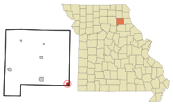
Location of Hunnewell, Missouri
|
|
| Country | United States |
| State | Missouri |
| County | Shelby |
| Area | |
| • Total | 0.62 sq mi (1.60 km2) |
| • Land | 0.62 sq mi (1.60 km2) |
| • Water | 0.00 sq mi (0.00 km2) |
| Elevation | 755 ft (230 m) |
| Population
(2020)
|
|
| • Total | 139 |
| • Density | 225.65/sq mi (87.07/km2) |
| Time zone | UTC-6 (Central (CST)) |
| • Summer (DST) | UTC-5 (CDT) |
| ZIP code |
63443
|
| Area code(s) | 573 |
| FIPS code | 29-33760 |
| GNIS feature ID | 0719996 |
Hunnewell is a small city located in southeastern Shelby County, Missouri, in the United States. In 2020, about 139 people lived there. It is a quiet community with a rich history.
Contents
History of Hunnewell
Hunnewell was officially started in 1857. This means its streets and building lots were planned out. The community got its name from H. H. Hunnewell. He was a famous financier from Boston and helped build railroads. A post office has been open in Hunnewell since 1880.
Geography of Hunnewell
Hunnewell is found in the southeast part of Shelby County. It is right next to US Route 36, a major road. Monroe City is about 6.5 miles (10.5 km) east in a nearby county. Shelbina is nine miles (14.5 km) west along Route 36.
North of the city, about two miles (3.2 km) away, is the Hunnewell Lake Conservation Area. This is a protected natural space. The North Fork of the Salt River flows about two miles (3.2 km) to the west. The city covers a total area of 0.62 square miles (1.6 square kilometers), and all of it is land.
Population and People
| Historical population | |||
|---|---|---|---|
| Census | Pop. | %± | |
| 1870 | 327 | — | |
| 1880 | 424 | 29.7% | |
| 1890 | 427 | 0.7% | |
| 1900 | 473 | 10.8% | |
| 1910 | 406 | −14.2% | |
| 1920 | 348 | −14.3% | |
| 1930 | 342 | −1.7% | |
| 1940 | 312 | −8.8% | |
| 1950 | 293 | −6.1% | |
| 1960 | 284 | −3.1% | |
| 1970 | 304 | 7.0% | |
| 1980 | 235 | −22.7% | |
| 1990 | 219 | −6.8% | |
| 2000 | 227 | 3.7% | |
| 2010 | 184 | −18.9% | |
| 2020 | 139 | −24.5% | |
| U.S. Decennial Census | |||
Hunnewell's Population in 2010
In 2010, the city of Hunnewell had 184 people living there. These people lived in 82 different homes. About 59 of these homes were families. The city had about 297 people per square mile (115 people per square kilometer).
Most of the people in Hunnewell were White (98.9%). A small number were Native American (0.5%) or from two or more races (0.5%). About 2.2% of the population was Hispanic or Latino.
Hunnewell Households
Out of the 82 households, about 31.7% had children under 18 years old. Many homes (48.8%) were married couples living together. Some homes had a female head of household without a husband (12.2%). Others had a male head of household without a wife (11.0%). About 23.2% of all homes were single individuals. About 11% of homes had someone living alone who was 65 or older.
The average number of people in a household was 2.24. For families, the average was 2.59 people. The median age in the city was 41 years old. This means half the people were younger than 41 and half were older.
- About 19.6% of residents were under 18 years old.
- About 10.3% were between 18 and 24 years old.
- About 24.4% were between 25 and 44 years old.
- About 27.7% were between 45 and 64 years old.
- About 17.9% were 65 years or older.
More males lived in the city than females. About 53.3% of the population was male, and 46.7% was female.
See also
 In Spanish: Hunnewell (Misuri) para niños
 | Percy Lavon Julian |
 | Katherine Johnson |
 | George Washington Carver |
 | Annie Easley |

