Igboland facts for kids
Quick facts for kids
Igboland
Àlaịgbò/Ànaịgbò
|
|
|---|---|
| Àlà na ḿbà ṇ́dị́ Ìgbò | |
| Nickname(s):
The East
|
|
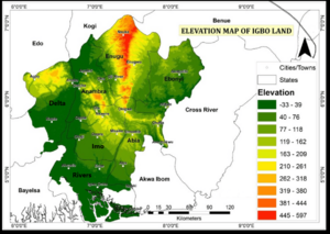
Complete Map of Igboland
|
|
| Part of | |
| - Founding of Nri | c. 900 |
| - British Colony | 1902 |
| - Nigeria | 1914 |
| Largest City | Onitsha |
| Founded by | Proto-Igbo |
| Regional capital | Enugu |
| Composed of |
States
|
| Government | |
| • Type | Autonomous communities |
| Area | |
| • Total | 40,000 km2 (16,000 sq mi) |
| Highest elevation | 1,000 m (3,300 ft) |
| Lowest elevation | 0 m (0 ft) |
| Population
(2020 estimate)
|
|
| • Total | 30 million ~ (22 million 5 main states) |
| • Density | 400/km2 (1,000/sq mi) |
| Demographics | |
| • Language | Igbo English |
| • Religion | Syncretic Christianity (>90%) Odinani (5-10%) |
| Time zone | UTC+1 (WAT) |
| God | Chukwu |
| Alusi | Ala |
| People | Ṇ́dị́ Ìgbò |
|---|---|
| Language | Ásụ̀sụ́ Ìgbò |
| Country | Àlà Ị̀gbò |
Igboland (also called Àlà Ị̀gbò in the Igbo language) is the traditional home of the Igbo people. It is a special cultural area in southern Nigeria. This region is known for its unique Igbo culture and the many different Igbo languages spoken there.
Geographically, the lower Niger River divides Igboland into two parts: a larger eastern part and a smaller western part. Politically, Igboland is part of several southern Nigerian states. These include Abia, Anambra, Delta, Ebonyi, Enugu, Imo, and Rivers states.
Contents
Where is Igboland?
Igboland is surrounded by large rivers and other Nigerian tribes. These include the Igala, Tiv, Yako, Idoma, and Ibibio.
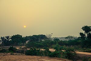
The region is mostly covered by lowland forests. Some parts also extend into the Niger Delta, where the Niger River flows into the Atlantic Ocean. This area has many creeks and mangrove swamps.
The oldest settlements found in Igboland date back to about 900 BCE. Most Igbo-speaking people are thought to have moved from this central area. The Kingdom of Nri in northern Igboland started around the 10th century CE. It is believed to have shaped much of Igboland's culture and traditions. Nri is the oldest kingdom still existing in Nigeria today.
In the late 1800s, Igboland became part of the British Empire. It was joined with other areas to form modern-day Nigeria in 1914. Nigeria became independent in 1960. Soon after, Igboland was involved in the Nigerian Civil War (1967-1970). This war happened when the region tried to become a separate country called Biafra.
Geography and Natural Environment
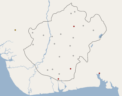
Igboland covers a large part of southeastern Nigeria. It is mainly on the eastern side of the Niger River. The territory also stretches west across the Niger River into parts of Delta State. To the east, it reaches the Cross River. Its northernmost point touches the Savannah climate near Nsukka.
Today, Igboland includes most of Abia, Anambra, Ebonyi, Enugu, Imo, and parts of Delta and Rivers states. Over 30 million people live in Igboland. It is one of the most densely populated areas in Africa. The total area of Igboland is about 15,800 to 16,000 square miles.
Ancient Trade and Connections
Igboland's culture has been shaped by its rainforest climate and old trade routes. Rivers helped people communicate and trade easily. This also allowed people to migrate into and out of Igboland.
In the mid-1800s, European traders like W. B. Baikie came to Igboland. They signed trade agreements with Igbo chiefs. One important route was along the lower Niger River. This river helped connect Igbo people on both sides. Other routes included the Njaba-Oguta lake-Orashi waterways. These routes helped Igboland trade with other parts of the world.
History of the Igbo People
Early Settlements and Stone Age Discoveries
Evidence shows that humans lived in Igboland at least 10,000 years ago. Pottery found in areas like Okigwe and Awka dates back to 6000 BC. In 1978, scientists found a rock quarry that was used for making tools and pottery.
Other discoveries include fossils and large stone structures from 4500 BC. These were found at Ngodo in Uturu. Researchers also found signs of a metal culture from 3000 BC near Nsukka. It's not fully clear how these ancient findings connect to today's Igbo people.
Many Igbo people are believed to have spread out from a smaller area in the Nsukka-Okigwe region. They formed different Igbo-speaking groups, villages, and kingdoms. Some groups, like the Mbaise, believe they have always lived in their current location.
Igbo-Ukwu: Ancient Art and Trade (AD 300–900)
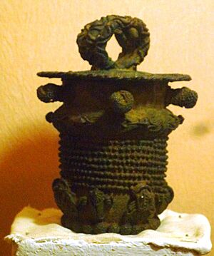
The first ancient metal objects in Igbo-Ukwu were found by accident in 1939. A man named Isiah Anozie discovered them while digging. Later, archaeologists found more linked metal works from the 9th century.
At first, experts thought these bronze and copper items were made elsewhere. They seemed too advanced for the time. But it was later discovered that local copper was used. The art also showed Igbo cultural signs, like special facial marks. This proved that the Igbo people developed their own advanced bronze industry.
Ancient Igbo trade routes reached far-off cities like Mecca and Medina. Beads from India, dating to the 9th century, have been found in Igbo-Ukwu burial sites. Thousands of glass beads were found on the clothes of a buried nobleman. This burial site was linked to the Nri Kingdom.
The Kingdom of Nri (900–c. 1560)
The Kingdom of Nri in northern Igboland began around the 10th century. It is believed to have set many of Igboland's cultural and religious practices. It is the oldest existing monarchy in Nigeria.
Around the mid-10th century, a divine figure named Eri is said to have arrived. He came to the Anambra River area. Eri is seen as a leader sent from heaven to start civilization. His exact origins are a bit of a mystery.
Later, around the 14th or 15th centuries, other groups came into Igboland. They mixed with the local people. To the west of Igboland, across the Niger River, a man named Eze Chima came from Benin. He and his followers settled in new lands and started new communities. These places are now known as Umuezechima, meaning 'the children or descendants of king Chima'.
European Contact and Early Conflicts (1450–1750)
Early European explorers called Igboland by names like Ibo(e) Country. The British Empire eventually took control of Igboland. This happened after many years of resistance from the Igbo people. Famous acts of resistance include the Ekumeku Movement and the Anglo-Aro War.
The Aro Confederacy and Trade (1750–1850)
The Aro Confederacy was a powerful kingdom that grew in the Cross River region. It rose in the 17th century and declined after the British arrived. The Aro state, centered at Arochukwu, became important as trade with Europeans grew. They played a big role in the trade of goods and people.
The Arochukwu area was first settled by the Ibibio people. Later, two main Igbo groups and some other mercenaries took control. These groups helped form the Aro Confederacy.
Colonial Rule and Changes (1850–1960)
After Britain stopped the slave trade in 1807, they started trading other goods like palm oil. This trade led to more contact between the Igbo and other groups. It also helped the Igbo people feel more like a distinct ethnic group.
Christian missionaries began arriving in the 1850s. At first, the Igbo were cautious. But as traditional society changed, many started to accept Christianity and Western education. Christianity brought new ideas and sometimes changed old cultural practices.
British colonial rule was often difficult because the Igbo had a decentralized government. This was different from the British centralized system. The British introduced "warrant chiefs" as rulers, even where there were no traditional kings. British rule also made the differences between the Igbo and other large ethnic groups, like the Hausa and Yoruba, more noticeable.
Independence and the Nigerian Civil War (1960s)
Nigeria became independent from the United Kingdom in 1960. Most of Igboland was part of Nigeria's Eastern Region.
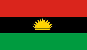
In 1966, there was a military coup in Nigeria. Later, a counter-coup led to the death of the military head of state, General Johnson Aguiyi-Ironsi. This event caused a lot of tension between different ethnic groups.
Because of these events, the people of the Eastern Region decided to form their own country. On May 30, 1967, they declared independence as the Republic of Biafra. General Emeka Odumegwu-Ojukwu became the head of this new republic.
The Nigerian Civil War (also called the "Nigerian-Biafran War") lasted from July 6, 1967, to January 15, 1970. Biafra was defeated after three years of fighting. It became part of Nigeria again. The war had a huge impact on the people of Biafra, especially the Igbo. Today, some groups, like the MASSOB, still work for Biafran independence.
|
 | Victor J. Glover |
 | Yvonne Cagle |
 | Jeanette Epps |
 | Bernard A. Harris Jr. |


