
Rivers State, Nigeria facts for kids
Quick facts for kids
Rivers State
|
|||
|---|---|---|---|
|
State
|
|||
|
|||
| Nickname(s):
Treasure Base of the Nation
|
|||

Location of Rivers State in Nigeria
|
|||
| Country | |||
| Geopolitical zone | South South | ||
| Formation | 27 May 1967 | ||
| Capital | Port Harcourt | ||
| LGAs | 23 | ||
| Government | |||
| • Body | Government of Rivers State | ||
| Area | |||
| • Total | 11,077 km2 (4,277 sq mi) | ||
| Area rank | 26th | ||
| Population
(2006 Census)
|
|||
| • Total | 5,198,716 | ||
| • Rank | 6th | ||
| • Density | 635.89/km2 (1,646.9/sq mi) | ||
| Demonym(s) | Riverian | ||
| GDP (PPP) | |||
| • Year | 2007 | ||
| • Total | $21.07 billion | ||
| • Per capita | $3,965 | ||
| Time zone | UTC+01 (WAT) | ||
| postal code |
500001
|
||
| ISO 3166 code | NG-RI | ||
| HDI (2018) | 0.642 medium · 6th of 37 |
||
Rivers State is a special part of Nigeria, one of its 36 states. In 2006, over 5 million people lived here. This makes it the sixth most populated state in Nigeria. Its capital and biggest city is Port Harcourt. This city is also very important for Nigeria's oil industry.
Rivers State is located in southern Nigeria. To the south, it touches the Atlantic Ocean. To the north, it shares borders with Imo State, Abia State, and Anambra State. To the east, it borders Akwa Ibom State. To the west, it is next to Bayelsa State and Delta State.
Many different groups of indigenous peoples call Rivers State home. These include the Ikwerre, Ijwa, Etche, Ogba/Egbema, and Ogoni.
Contents
Geography of Rivers State
Rivers State is mostly flat land in southern Nigeria. It is found in the eastern part of the Niger Delta. The northern part of the state has tropical rainforests. Closer to the coast, you will find many mangrove swamps. Rivers State covers about 11,077 square kilometers. This makes it the 26th largest state in Nigeria.
The land here is generally less than 20 meters above sea level. It has many rivers and smaller streams.
Climate and Weather
Rivers State has a wet season that lasts a long time. It usually rains from March to October or November. The heaviest rain happens in July. The only dry months are January and February, but even then, some rain can fall.
The amount of rain changes across the state. Near the coast, it can get about 4,700 millimeters of rain each year. In the far north, it gets about 1,700 millimeters. For Port Harcourt, temperatures stay pretty much the same all year. They are usually between 25 and 28 degrees Celsius. The air is almost always humid, often between 90% and 100%.
Land and Soil
The land in Rivers State has three main types. These are freshwater swamps, mangrove swamps, and coastal sand ridges. The freshwater zone is north of the mangrove swamps. This area is often flooded by rivers.
The coastal sand ridges have sandy soils. These soils are good for growing many crops. Some crops include coconuts, oil palms, raffia palms, and cocoyams. The drier, higher land makes up 61% of the state. The river areas, which are lower, make up 39%.
Plants and Animals


Rivers State is important for Nigeria's natural history. It has many different animals and plants. Its tropical rainforests have more species than other similar areas. This is because of the climate and the tall trees that form a canopy. Sadly, some forest areas have been harmed by human activities. This has affected the variety of life and the natural environment.
The river areas have three types of plant zones. These are beach ridge, salt water, and fresh water zones. Each zone has its own special plants.
Finima Nature Park is a protected area on Bonny Island. It covers about 10 square kilometers. The park's plants have grown into a tall forest since 1999. Inside the forest, it is very shady. Many plants that like shade grow there.
Many animals live in the park. Common mammals include mona monkeys and pygmy hippopotamuses. You can also find snakes, crocodiles, turtles, frogs, lizards, and skinks.
The Upper Orashi Forest is a special wetland recognized by the Ramsar Convention. It is about 252 square kilometers and is in Ahoada West. This forest is important for birds, especially grey parrots.
The Biseni Forest is also an important bird area. It is in the northwest of Ahoada. This forest is home to mammals like red-bellied monkeys and yellow-backed duikers.
Rivers of the State
_annotated.svg)
Rivers State has many important rivers. Some of these include:
- Santa Barbara River
- Bonny River
- Andoni River
- New Calabar River
- Nun River
- River Orashi
- San Bartholomeo River
- Emesu River
- Sombreiro River
- St Nicholas River
- Otamiriochie River
- Ogochie River
- Imo Miriochie River
- Oloshi River
- Opobo Channel River
Population of Rivers State
How Many People Live Here?
| Historical population | ||
|---|---|---|
| Year | Pop. | ±% p.a. |
| 1991 | 3,187,844 | — |
| 2006 | 5,198,716 | +3.31% |
| 2015 (Est.) | 7,043,800 | +3.43% |
| Source: | ||
From 1991 to 2006, the number of people in Rivers State grew a lot. It increased by almost 3 million people. The last official count in 2006 showed 5,198,716 people lived in the state. More than half of them were men.
Rivers State has a higher literacy rate than many other states in its region. This means more people here can read and write.
Economy and Resources

Rivers State has been a major source of wealth for Nigeria for a very long time. In 2007, the state was ranked second in the country for its gross domestic product (GDP). Its GDP was $21.07 billion. This shows how much money the state's economy makes.
Natural Resources
The state is well-known for its large amounts of crude oil and natural gas. It was once a very rich and important part of the British Empire in Africa. Rivers State has two big oil refineries. It also has two main seaports and airports. Over 60% of Nigeria's crude oil comes from this state. Other natural resources found here include silica sand, glass sand, and clay.
Farming and Fishing
Before oil was found in large amounts in 1951, farming was the main job for people in Rivers State. In the 1800s, this area was called the "Oil Rivers Protectorate." This was because of its rich supply of palm oil and palm kernels. These products were the country's main source of income.
In 1983, a survey showed that about 40% of people in rural areas were farmers. Rivers State is a top producer of crops like yam, cassava, cocoyam, maize, rice, and beans. About 39% of the state's land is good for farming.
Important crops grown for money include oil palm products, rubber, coconut, and raffia palm. Other crops grown for food are vegetables, melon, pineapples, mango, and bananas. Fishing is also a very important business in Rivers State. It is both profitable and a popular hobby. There are about 270 types of fish here. Many fishermen work in the river areas. The state provides tasty seafood like crabs, oysters, shrimps, and sea snails.
Images for kids
-
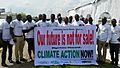
Ogoni Climate activists and others in Port Harcourt protesting environmental degradation in 2015.

See also
 In Spanish: Estado de Rivers para niños
