Iitate, Fukushima facts for kids
Quick facts for kids
Iitate
飯舘村
|
|||||||||||||
|---|---|---|---|---|---|---|---|---|---|---|---|---|---|

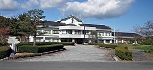
Iitate Village Office
|
|||||||||||||
|
|||||||||||||

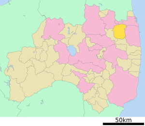
Location of Iitate in Fukushima Prefecture
|
|||||||||||||
| Country | Japan | ||||||||||||
| Region | Tōhoku | ||||||||||||
| Prefecture | Fukushima | ||||||||||||
| District | Sōma | ||||||||||||
| Area | |||||||||||||
| • Total | 230.13 km2 (88.85 sq mi) | ||||||||||||
| Population
(Feb 1, 2020)
|
|||||||||||||
| • Total | 1,408 | ||||||||||||
| • Density | 6.1183/km2 (15.846/sq mi) | ||||||||||||
| Time zone | UTC+9 (Japan Standard Time) | ||||||||||||
| Phone number | 24-562-4200 | ||||||||||||
| Address | 580-1 Itazawa, Iitate-mura, Soma-gun, Fukushima-ken 960-1892 | ||||||||||||
| Climate | Cfa/Dfa | ||||||||||||
|
|||||||||||||
Iitate (pronounced Ee-tah-teh) is a small village in Fukushima Prefecture, Japan. As of February 1, 2020, about 1,408 people lived there. The village covers an area of about 230 square kilometers (89 square miles).
Contents
Geography of Iitate
Iitate is located in the Abukuma Plateau, which is a high, flat area in northeastern Fukushima. It sits at an average height of 500 meters (1,640 feet) above sea level. The village is about 39 kilometers (24 miles) northwest of the Fukushima Daiichi Nuclear Power Plant.
Neighboring Towns and Cities
Iitate shares its borders with several other places in Fukushima Prefecture:
- Date
- Sōma
- Minamisōma
- Namie
- Kawamata
Climate in Iitate
Iitate has a humid climate. This means it gets a good amount of rain and has warm, humid summers. The average temperature each year is about 10.2 degrees Celsius (50.4 degrees Fahrenheit). September is usually the wettest month. Temperatures are highest in August, around 22.9 degrees Celsius (73.2 degrees Fahrenheit). They are lowest in January, around -1.2 degrees Celsius (29.8 degrees Fahrenheit).
| Climate data for Iitate (1991−2020 normals, extremes 1976−present) | |||||||||||||
|---|---|---|---|---|---|---|---|---|---|---|---|---|---|
| Month | Jan | Feb | Mar | Apr | May | Jun | Jul | Aug | Sep | Oct | Nov | Dec | Year |
| Record high °C (°F) | 14.4 (57.9) |
19.8 (67.6) |
23.0 (73.4) |
29.3 (84.7) |
31.2 (88.2) |
33.8 (92.8) |
35.2 (95.4) |
36.0 (96.8) |
35.8 (96.4) |
28.3 (82.9) |
24.1 (75.4) |
21.3 (70.3) |
36.0 (96.8) |
| Mean daily maximum °C (°F) | 3.4 (38.1) |
4.4 (39.9) |
8.5 (47.3) |
15.0 (59.0) |
20.3 (68.5) |
22.8 (73.0) |
26.5 (79.7) |
27.7 (81.9) |
23.6 (74.5) |
18.1 (64.6) |
12.7 (54.9) |
6.5 (43.7) |
15.8 (60.4) |
| Daily mean °C (°F) | −1.1 (30.0) |
−0.6 (30.9) |
2.9 (37.2) |
8.6 (47.5) |
14.0 (57.2) |
17.6 (63.7) |
21.4 (70.5) |
22.4 (72.3) |
18.4 (65.1) |
12.4 (54.3) |
6.7 (44.1) |
1.6 (34.9) |
10.4 (50.6) |
| Mean daily minimum °C (°F) | −6.0 (21.2) |
−6.0 (21.2) |
−2.6 (27.3) |
2.1 (35.8) |
7.7 (45.9) |
12.7 (54.9) |
17.4 (63.3) |
18.3 (64.9) |
14.0 (57.2) |
7.2 (45.0) |
0.9 (33.6) |
−3.2 (26.2) |
5.2 (41.4) |
| Record low °C (°F) | −21.3 (−6.3) |
−20.9 (−5.6) |
−18.3 (−0.9) |
−13.9 (7.0) |
−2.7 (27.1) |
2.7 (36.9) |
7.3 (45.1) |
7.2 (45.0) |
1.7 (35.1) |
−4.6 (23.7) |
−7.6 (18.3) |
−21.0 (−5.8) |
−21.3 (−6.3) |
| Average precipitation mm (inches) | 60.5 (2.38) |
41.1 (1.62) |
77.4 (3.05) |
103.1 (4.06) |
97.8 (3.85) |
131.7 (5.19) |
174.2 (6.86) |
189.5 (7.46) |
204.4 (8.05) |
170.5 (6.71) |
56.3 (2.22) |
48.4 (1.91) |
1,367.4 (53.83) |
| Average precipitation days (≥ 1.0 mm) | 7.7 | 6.6 | 9.0 | 8.9 | 9.8 | 12.2 | 14.2 | 12.1 | 12.3 | 9.6 | 7.0 | 8.2 | 117.6 |
| Mean monthly sunshine hours | 151.6 | 155.7 | 182.7 | 192.3 | 201.4 | 150.9 | 138.9 | 163.0 | 125.9 | 139.2 | 142.6 | 137.0 | 1,881 |
| Source: Japan Meteorological Agency | |||||||||||||
Population Changes in Iitate
The number of people living in Iitate was highest in the mid-1950s. Since then, the population has slowly decreased. In 2020, the population was 1,318.
| Historical population | ||
|---|---|---|
| Year | Pop. | ±% |
| 1920 | 6,387 | — |
| 1930 | 7,173 | +12.3% |
| 1940 | 8,015 | +11.7% |
| 1950 | 10,725 | +33.8% |
| 1960 | 11,129 | +3.8% |
| 1970 | 9,385 | −15.7% |
| 1980 | 8,331 | −11.2% |
| 1990 | 7,920 | −4.9% |
| 2000 | 7,093 | −10.4% |
| 2010 | 6,209 | −12.5% |
| 2020 | 1,318 | −78.8% |
History of Iitate
The area where Iitate is located today was once part of an old Japanese province called Mutsu Province. During the Edo period (1603-1868), this area was controlled by the Sōma family.
In 1889, after the Meiji restoration (a big change in Japan's government), three smaller villages named Iiso, Osu, and Niitate were created. Later, in 1942, Osu and Niitate joined together to form Odate village. Then, in 1956, Odate merged with Iiso to create the village of Iitate as we know it today. In 2010, Iitate was recognized as one of The Most Beautiful Villages in Japan.
Impact of the 2011 Fukushima Nuclear Disaster
Iitate was affected by the powerful 2011 Tōhoku earthquake and tsunami in March 2011. Even though it was outside the main 30-kilometer (19-mile) safety zone around the Fukushima Daiichi Nuclear Power Plant, wind patterns carried radiation to the village.
Because of this, the government ordered everyone in Iitate to leave their homes on April 22, 2011. Many families had to move. Some children who moved away faced difficulties because people worried about radiation. By August 2011, most residents had left, with only a small number, mainly older people, remaining.
In 2012, a survey showed that many former residents felt stressed and unsettled after leaving their homes. About 60% of them felt their health had gotten worse. The survey also showed that many families were separated, with one-third living apart from their children. About half lived away from other family members they used to live with. Many also saw their income drop.
In March 2012, Iitate was divided into three areas based on radiation levels. In some areas, people could visit during the day but not stay overnight. In others, visits were very limited. Some parts were completely closed off due to high radiation.
The government planned to lift the evacuation order for most of the village in 2016. However, due to remaining radiation levels, this was delayed until March 2017. On April 1, 2017, the evacuation order was lifted for most of Iitate. A small area near the town of Namie remains a no-entry zone. Even though people could return, only about one-third of the former residents planned to do so.
Economy
In the past, Iitate's economy mostly depended on agriculture, which means farming.
Education
Before the 2011 disaster, Iitate had three public elementary schools and one public junior high school. There was also one high school. All these schools were closed when the village was evacuated in March 2011.
Transportation
Railway
Iitate does not have any train stations or passenger train services.
Highways
- Route 399 runs through Iitate.
See also
 In Spanish: Iitate (Fukushima) para niños
 | Tommie Smith |
 | Simone Manuel |
 | Shani Davis |
 | Simone Biles |
 | Alice Coachman |


