Iizuka, Fukuoka facts for kids
Quick facts for kids
Iizuka
飯塚市
|
|||||||||||
|---|---|---|---|---|---|---|---|---|---|---|---|

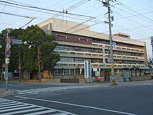
Iizuka City Hall
|
|||||||||||
|
|||||||||||
 |
|||||||||||
| Country | Japan | ||||||||||
| Region | Kyushu | ||||||||||
| Prefecture | Fukuoka | ||||||||||
| Area | |||||||||||
| • Total | 213.96 km2 (82.61 sq mi) | ||||||||||
| Population
(February 29, 2024)
|
|||||||||||
| • Total | 124,757 | ||||||||||
| • Density | 583.086/km2 (1,510.18/sq mi) | ||||||||||
| Time zone | UTC+09:00 (JST) | ||||||||||
| City hall address | 5-5 Shintateiwa, Iizuka-shi, Fukuoka-ken 820-8501 | ||||||||||
| Climate | Cfa | ||||||||||
|
|||||||||||
Iizuka (飯塚市, Iizuka-shi) is a city in Fukuoka Prefecture, Japan. It is located on the island of Kyushu. As of February 29, 2024, about 124,757 people live there in 63,833 homes. The city covers a total area of 213.96 square kilometers.
Contents
Geography of Iizuka City
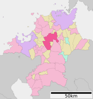
Iizuka is in the middle of Fukuoka Prefecture. It is about 35 kilometers east of Fukuoka City. It is also about 40 kilometers southwest of Kitakyushu City. The Onga River flows through the city center. This river helps create the city's main urban area.
Mountains and Passes
Mountains surround Iizuka. In the northwest, west, and southwest, mountains are 400 to 900 meters high. These include Mount Mikoriyama (935.9 meters) and Mount Toishi (828 meters). The eastern part of the city has smaller mountains, about 200 to 300 meters high. This means the central and northern parts of Iizuka are like a basin surrounded by hills.
Some mountain passes were once hard to cross. These include Yagiyama Pass and Shokegoe in the west. Hiyomizu Pass is in the south. Roads have made travel much easier now.
Nearby Towns and Cities
Iizuka shares borders with several other places in Fukuoka Prefecture:
- Nōgata
- Chikushino
- Tagawa
- Miyawaka
- Kama
- Keisen
- Sasaguri
- Sue
- Umi
- Itoda
- Fukuchi
- Kotake
- Chikuzen
Iizuka's Climate
Iizuka has a humid subtropical climate. This means it has warm summers and cool winters. There is usually little to no snow. The average temperature each year is about 15.1 degrees Celsius. September is the wettest month, with about 1560 mm of rain per year. August is the warmest month, averaging 26.4 degrees Celsius. January is the coldest, averaging 4.0 degrees Celsius. It rains a lot throughout the year, especially in summer.
| Climate data for Iizuka, Fukuoka (1991−2020 normals, extremes 1935−present) | |||||||||||||
|---|---|---|---|---|---|---|---|---|---|---|---|---|---|
| Month | Jan | Feb | Mar | Apr | May | Jun | Jul | Aug | Sep | Oct | Nov | Dec | Year |
| Record high °C (°F) | 20.8 (69.4) |
23.7 (74.7) |
25.9 (78.6) |
30.3 (86.5) |
34.2 (93.6) |
35.7 (96.3) |
37.6 (99.7) |
38.3 (100.9) |
36.6 (97.9) |
32.9 (91.2) |
28.1 (82.6) |
25.3 (77.5) |
38.3 (100.9) |
| Mean daily maximum °C (°F) | 9.6 (49.3) |
11.0 (51.8) |
14.5 (58.1) |
20.0 (68.0) |
24.7 (76.5) |
27.3 (81.1) |
31.0 (87.8) |
32.1 (89.8) |
28.2 (82.8) |
23.2 (73.8) |
17.5 (63.5) |
11.9 (53.4) |
20.9 (69.7) |
| Daily mean °C (°F) | 5.3 (41.5) |
6.2 (43.2) |
9.4 (48.9) |
14.3 (57.7) |
19.1 (66.4) |
22.6 (72.7) |
26.6 (79.9) |
27.3 (81.1) |
23.4 (74.1) |
17.8 (64.0) |
12.3 (54.1) |
7.3 (45.1) |
16.0 (60.7) |
| Mean daily minimum °C (°F) | 1.3 (34.3) |
1.7 (35.1) |
4.6 (40.3) |
9.1 (48.4) |
14.0 (57.2) |
18.9 (66.0) |
23.3 (73.9) |
23.8 (74.8) |
19.7 (67.5) |
13.4 (56.1) |
7.7 (45.9) |
2.9 (37.2) |
11.7 (53.1) |
| Record low °C (°F) | −9.7 (14.5) |
−8.1 (17.4) |
−6.0 (21.2) |
−2.4 (27.7) |
1.1 (34.0) |
7.8 (46.0) |
13.1 (55.6) |
15.0 (59.0) |
7.1 (44.8) |
−0.4 (31.3) |
−2.3 (27.9) |
−5.1 (22.8) |
−9.7 (14.5) |
| Average precipitation mm (inches) | 76.5 (3.01) |
78.6 (3.09) |
115.5 (4.55) |
128.6 (5.06) |
149.0 (5.87) |
281.8 (11.09) |
347.1 (13.67) |
209.6 (8.25) |
178.0 (7.01) |
89.5 (3.52) |
89.1 (3.51) |
70.3 (2.77) |
1,813.6 (71.4) |
| Average snowfall cm (inches) | 4 (1.6) |
3 (1.2) |
0 (0) |
0 (0) |
0 (0) |
0 (0) |
0 (0) |
0 (0) |
0 (0) |
0 (0) |
0 (0) |
1 (0.4) |
8 (3.2) |
| Average rainy days | 9.8 | 9.5 | 10.9 | 10.0 | 8.6 | 12.0 | 12.1 | 9.8 | 9.9 | 6.8 | 8.8 | 9.2 | 117.4 |
| Average snowy days | 0.9 | 0.9 | 0.1 | 0 | 0 | 0 | 0 | 0 | 0 | 0 | 0.1 | 0.1 | 2.1 |
| Average relative humidity (%) | 72 | 71 | 70 | 69 | 70 | 78 | 80 | 78 | 79 | 76 | 76 | 73 | 74 |
| Mean monthly sunshine hours | 103.0 | 119.4 | 156.6 | 181.9 | 199.8 | 137.3 | 161.0 | 191.2 | 154.5 | 171.0 | 136.9 | 115.6 | 1,828.2 |
| Source: Japan Meteorological Agency | |||||||||||||
Population Changes Over Time
The population of Iizuka has changed over the years. Here is how it has grown and shrunk:
| Historical population | ||
|---|---|---|
| Year | Pop. | ±% |
| 1950 | 194,132 | — |
| 1960 | 186,760 | −3.8% |
| 1970 | 126,934 | −32.0% |
| 1980 | 135,852 | +7.0% |
| 1990 | 139,663 | +2.8% |
| 2000 | 136,701 | −2.1% |
| 2010 | 131,492 | −3.8% |
| 2020 | 126,364 | −3.9% |
History of Iizuka
The area where Iizuka is located was once part of an old region called Chikuzen Province. People have grown rice in the rich plains of the Onga River area since the Yayoi Period (around 300 BC to 300 AD). You can still find ancient burial mounds, called kofun, scattered around.
During the Edo Period (1603-1868), Iizuka was an important stop on the Nagasaki Kaidō, a major road. After the Meiji restoration in 1868, the town of Iizuka was officially created on April 1, 1889. It became a full city on January 20, 1932.
On March 26, 2006, Iizuka grew bigger. It joined with the towns of Chikuho, Honami, Kaita, and Shōnai. These towns were all from the Kaho District. This made the new, larger city of Iizuka.
Iizuka's Economy
Iizuka was very important during the Edo Era as a post-station. Later, when Japan started to become an industrial country, Iizuka became a major center for coal mining. The area around it, called the Chikuho district, had some of the most productive coal fields in Japan.
After Second World War, many people moved to Iizuka. This was because the coal mines offered a lot of jobs. However, the coal mines eventually closed down. This caused Iizuka's population to slowly decrease.
Even with the coal mines closing, Iizuka's economy did not collapse. This is because it is close to both Fukuoka City and Kitakyushu City. Today, Iizuka has many light industries. It is also a growing center for education and IT (computer technology).
Education in Iizuka
Iizuka has many schools for young people. The city government runs 22 public elementary schools and 9 public junior high schools. There is also one private elementary school and one private junior high school.
For older students, the Fukuoka Prefectural Board of Education operates one public junior high school and two public high schools. There are also two private high schools. The prefecture also has two special schools for students with disabilities. Kindai University has a junior college in Iizuka, where students can study after high school.
Transportation in Iizuka
You can travel around Iizuka by train and car.
Railways
![]() JR Kyushu trains run on several lines:
JR Kyushu trains run on several lines:
- Chikuhō Main Line (also called Fukuhoku Yutaka Line)
- Stations: Tentō - Iizuka - Shin-Iizuka - Urata - Namazuta
- Chikuhō Main Line (Haruda Line)
- Stations: Chikuzen-Uchino - Kami-Honami
- Sasaguri Line
- Stations: Chikuzen-Daibu - Kurōbaru
- Gotōji Line
- Stations: Chikuzen-Shōnai - Kami-Mio - Shin-Iizuka
Highways
Major roads that pass through Iizuka include:
 National Route 200
 National Route 201
 National Route 211
Sister City
Iizuka has a special friendship with one city in the United States:
 Sunnyvale, California, United States
Places to Visit in Iizuka
- Chikuhō Coalfield Sites: These are places that show the history of coal mining in the area.
- Daibu temple ruins: These are the remains of an old temple. They are considered a National Historic Site.
Famous People from Iizuka
- Tarō Asō: He was a former prime minister of Japan. He was born in Iizuka and still has a large home there.
- Mari Shirato: An actress.
- Yumi Yoshino: An actress.
See also
 In Spanish: Iizuka (Fukuoka) para niños


