Iliff, Colorado facts for kids
Quick facts for kids
Town of Iliff, Colorado
|
|
|---|---|

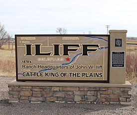
Iliff, Colorado sign at the west end of town.
|
|

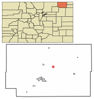
Location of Iliff in Logan County, Colorado.
|
|
| Country | |
| State | |
| County | Logan |
| Incorporated (town) | February 20, 1906 |
| Government | |
| • Type | Statutory Town |
| Area | |
| • Total | 0.19 sq mi (0.49 km2) |
| • Land | 0.19 sq mi (0.49 km2) |
| • Water | 0.00 sq mi (0.00 km2) |
| Elevation | 3,835 ft (1,169 m) |
| Population
(2020)
|
|
| • Total | 246 |
| • Density | 1,290/sq mi (502/km2) |
| Time zone | UTC-7 (Mountain (MST)) |
| • Summer (DST) | UTC-6 (MDT) |
| ZIP code |
80736
|
| Area code(s) | 970 |
| FIPS code | 08-38590 |
| GNIS feature ID | 171118 |
The Town of Iliff is a small town located in Logan County, Colorado, in the United States. It's known as a Statutory Town, which means it follows certain rules set by the state of Colorado for how towns are run. In 2020, about 246 people lived there.
Contents
A Look Back at Iliff's History
Iliff was named after John Wesley Iliff, a famous cattle rancher who owned land nearby.
The people of Iliff have always been strong and able to bounce back from challenges. For example, they survived a big snowstorm in 1949 and a flood in 1968. The town is built on the rich land next to the South Platte River. This river has been very important to the community for a long time.
Early Days and Growth
The very first building in Iliff was a Post Office and a Real Estate Office, built way back in 1870. On January 6, 1885, the town was officially mapped out. A few months later, in May, a school district was started.
By 1887, Iliff had a grocery store and a lumber yard. The Iliff Bank opened in 1907. By 1915, the town had a Baptist church and a John Deere farm equipment dealership. A company called Farmer's Alfalfa Milling Company started in 1918. There were also two doctors, Daniels and Houff, who ran a drug store. In 1920, the Glory Park Theater opened, giving people a place to watch movies.
In 1923, the town hired a Marshall, which is like a police officer, and an old train car was used as a jail. The Catholic Church was built in 1928.
Changes Over Time
The town's growth slowed down during the Great Depression in the 1930s and again during World War II. In 1957, there were eleven businesses in Iliff. However, over time, many of these businesses closed. This happened because more people started driving the 12 miles to Sterling, Colorado, to shop. Also, when Interstate 76 opened, it took most long-distance travelers off the local highway 138, which meant fewer visitors for Iliff's businesses.
Iliff's Location and Size
Iliff is located at coordinates 40°45′32″N 103°03′57″W / 40.758911°N 103.065841°W.
According to the United States Census Bureau, the town covers a total area of about 0.2 square miles (0.49 square kilometers). All of this area is land.
Population Information
Demographics is the study of a population, including how many people live in a place and how that number changes over time. Here's how Iliff's population has changed over the years:
| Historical population | |||
|---|---|---|---|
| Census | Pop. | %± | |
| 1920 | 238 | — | |
| 1930 | 266 | 11.8% | |
| 1940 | 322 | 21.1% | |
| 1950 | 235 | −27.0% | |
| 1960 | 204 | −13.2% | |
| 1970 | 193 | −5.4% | |
| 1980 | 218 | 13.0% | |
| 1990 | 174 | −20.2% | |
| 2000 | 213 | 22.4% | |
| 2010 | 266 | 24.9% | |
| 2020 | 246 | −7.5% | |
| U.S. Decennial Census | |||
See also
 In Spanish: Iliff (Colorado) para niños
 | Stephanie Wilson |
 | Charles Bolden |
 | Ronald McNair |
 | Frederick D. Gregory |

