
Image: Lake eyre basin map

Size of this preview: 600 × 600 pixels. Other resolutions: 240 × 240 pixels | 990 × 990 pixels.
Original image (990 × 990 pixels, file size: 292 KB, MIME type: image/png)
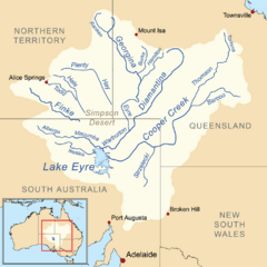
Description: This is a map of the Lake Eyre drainage basin including the major rivers. Note that the river courses shown are usually dry.
Title: Lake eyre basin map
Credit: Own work using Digital Chart of the World. The Rand McNally New International Atlas (1993) and this Department of the Environment, Water, Heritage and the Arts map used as references.
Author: Kmusser
Usage Terms: Creative Commons Attribution-Share Alike 3.0
License: CC BY-SA 3.0
License Link: http://creativecommons.org/licenses/by-sa/3.0
Attribution Required?: Yes
Image usage

All content from Kiddle encyclopedia articles (including the article images and facts) can be freely used under Attribution-ShareAlike license, unless stated otherwise.