Geology of South Australia facts for kids
South Australia is a large state in the southern middle part of Australia. It has some low mountain ranges, like the Mount Lofty Ranges, which reach into the capital city, Adelaide. Most of the state's people live in Adelaide. The city sits on the eastern side of Gulf St Vincent, on the Adelaide Plains.
The search for underground water and valuable minerals has been a big reason why people have studied South Australia's geology. Geology is the study of Earth's rocks and how they change over time. Because South Australia is in the middle of the continent, it has rocks of many different ages and types. These rocks are great places to look for minerals. South Australia also has some of Australia's newest volcanoes, like Mount Gambier, which last erupted about 6,000 years ago.
Studying the geology of South Australia helps us understand its rocks, how the land changes, and its natural features. It also connects to the history of its Aboriginal peoples. Some geological spots, like Mount Gambier, are important for the local economy, especially for tourism. Many of these special places are kept safe and protected. South Australia covers a huge area of over 983,482 square kilometres, so it has a very rich geological past.
The state has been a major source of mined resources for a long time, going back to the first 100 years of settlement. The mining industry here relies on the geology. South Australia has more than twenty mines, and in the 2010s, mineral production grew four times! Mining makes up 40% of the state's exports and is a big area for government and private investment.
Contents
Adelaide Superbasin: Ancient Rocks and Treasures
The Adelaide Superbasin is a huge area of very old rock layers, formed from mud and sand. These rocks were laid down between about 1,000 million and 500 million years ago. You can find them on the eastern edge of the Gawler Craton, stretching from the Davenport and Denison Ranges all the way to Kangaroo Island, and even into New South Wales. It's named after the city of Adelaide.
This superbasin first formed when a supercontinent called Rodinia broke apart. Rocks continued to form here until a mountain-building event called the Delamerian Orogeny. There are over 140 different types of rock layers in the Adelaide Superbasin. Its shape was affected by the movement of salt underground and changes in the land. The famous Flinders Ranges and the Mount Lofty Ranges are both found within the Adelaide Superbasin.
Scientists have studied the Adelaide Superbasin a lot because it shows evidence of Rodinia breaking up. It also has clues about two "Snowball Earth" events, which were times when Earth was almost completely covered in ice. Plus, it shows the rise of complex life forms, including the Ediacaran Fauna, which were some of the earliest large, soft-bodied creatures.
The most important mineral found here so far is copper. The historic Burra copper mine produced about 2.7 million tonnes of copper ore in its lifetime. People also look for and have mined gold, silver, zinc, cobalt, molybdenum, lead, iron, barite, magnesite, and talc in this area.
Gawler Craton: A Giant, Resource-Rich Land
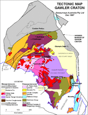
The Gawler Craton is a massive geological area in South Australia. It's about the same size as the United Kingdom! Smaller features within it include the Stuart Range Basin and the Pimba Platform. The Gawler Craton is bordered by the Great Australian Bight to the south and the Karari Shear Zone to the north. These boundaries often separate different types of rock found in the area.
The Gawler Craton started forming more than three billion years ago. This happened through a process where molten rock moved and cooled. The area continued to experience these processes, along with the laying down of sediments, until about one and a half billion years ago.
The Gawler Craton is full of resources, especially a type of rock called meta-sedimentary rock. Because it's so big and old, the Gawler Craton is also a source for many valuable metals and gems. These include jades, diamonds, copper, gold, iron, zinc, lead, cobalt, and nickel. Mining in this area has been very profitable, with an estimated value of $35 billion. However, because the Gawler Craton is so large and remote, mining can be difficult. To help with this, there have been ideas to build more transport links, like railways, to connect mines and small towns. This would help the state's economy grow.
Lake Eyre Basin: Australia's Giant Inland Lake System
Description
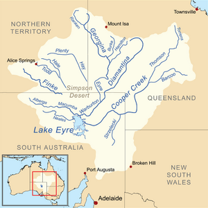
The Lake Eyre Basin is the largest endorheic basin in Australia, covering over 1.14 million square kilometres. An endorheic basin is a place where water collects but doesn't flow out to other bodies of water like oceans or rivers. Instead, the main ways water is lost are through evaporation (turning into vapor) and seepage (soaking into the ground).
This basin is in the northeast of South Australia, and most of its South Australian part is dry or semi-dry land. The Lake Eyre Basin has seven areas where water drains into it. Some of these, like the Georgina Diamantina, Cooper Creek, and Neales Peake catchments, are fully or partly in South Australia.
Rainfall is very important for the Lake Eyre Basin. It gets more rain in summer because of a high-pressure system. In winter, it gets less rain. For example, the Australian Bureau of Meteorology shows that in winter, rainfall was only 8mm, while in summer it was 38mm. In Lake Eyre and the South Australian parts of the basin, the average yearly rainfall is about 125mm. However, the average evaporation can be over 3600mm! This huge difference is why the land is so dry.
The Lake Eyre Basin is mostly made of rocks from the Mesozoic and Cenozoic eras, which means they formed from about 248 million years ago to today. There are also younger sediments on the surface. The basin formed because the land sank over 200 million years ago. About 100 million years ago, the ocean covered the basin due to sea-level changes, but it pulled back 25 million years ago. The Lake Eyre Basin became an endorheic basin about one million years ago, when salt lakes in the area started blocking water from flowing out to rivers.
Historical Importance
The Lake Eyre Basin is also very important in Aboriginal history and culture. Its Aboriginal name is Kati Thanda. In 2012, this name was added to the European name, making it Kati Thanda-Lake Eyre. The South Australian parts of the basin are part of the land called Kirrenderri, which the Mithaka people have lived on for nearly 50,000 years. Another Aboriginal area, Wahlduru, includes Cooper Creek, the Diamantina River, and the Georgina Rivers. The Mithaka people have kept the land well, showing their strong connection between land and culture.
Mount Gambier: A Young Volcano and Blue Lake
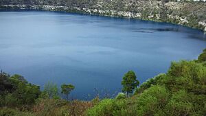
Mount Gambier is about 480 kilometres southeast of Adelaide, near the city also called Mount Gambier. The Mount Gambier Volcanic Complex is a special heritage area. It has four crater lakes: Blue Lake, Valley Lake, Leg of Mutton Lake, and Browne's Lake. This volcanic area is now dormant, meaning it's not active. Its last eruption was at least 4,300 years ago. This eruption, called a phreatic eruption, happened when underground water mixed with hot magma. This created the craters for Blue Lake and Valley Lake.
The Mount Gambier Volcanic Complex formed over 5,000 years ago, making it the youngest group of volcanoes in Australia. This age is an estimate based on different samples and methods. The volcano Mount Gambier is just one of many geological formations in the complex. Others include Mount Schank, Mount Napier, Mount Eccles, Tower Hill, Mount Pordon, and Mount Rouse, which range from three million to five thousand years old.
The volcanic complex has maar craters (wide, low-rimmed craters) and steam vents. These formed when shallow waters were heated by past volcanic activity. The water in Blue Lake, Valley Lake, Leg of Mutton Lake, and Browne's Lake used to be part of the water table (the top level of underground water) that was brought to the surface by the volcanic activity.
The city of Mount Gambier has strong ties to the volcano. It's the second-largest city in South Australia and a popular tourist spot because of its nearby geological features. These sites are well-preserved and unique, like Blue Lake, which changes colours depending on the time of year. The Bungandidj people have been the Indigenous guardians of the Mount Gambier Region for over 30,000 years.
Geomorphology: How the Land is Shaped
Mount Lofty Ranges: An Ancient Mountain Range
The Mount Lofty Ranges run from north to south, just east of Adelaide. They are surrounded by the western Murray Basin and the city of Adelaide. This region is about 300 kilometres long and covers 1,640 square kilometres, with its highest point reaching 936 metres.
Scientists believe the Mount Lofty Ranges started forming over 70 million years ago, during the late Cretaceous period or early Tertiary period. The very first formations in the region happened much earlier, in the Cambrian era, over 485 million years ago. The movement of Earth's tectonic plates in this area caused the land to sink, creating many shallow basins.
Sedimentary rock found in these basins formed over 14 million years ago. The area has fan-glomerates, which are rocks made of coarse fragments. These formed due to changing weather conditions, including times of heavy rainfall and steam, mixed with calm weather. The region also has rough ridges because of constant erosion. The Mount Lofty Ranges have steep slopes, which were created when the Earth's surface lifted by over 500 metres along its western parts.


