
Image: Pennsylvania canals
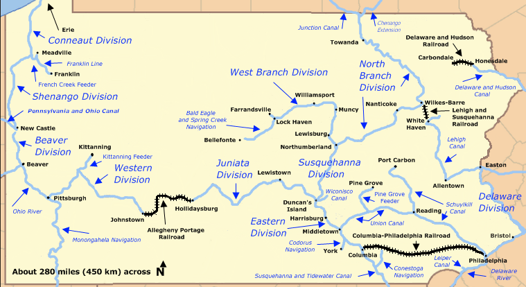
Description: Historic canals of Pennsylvania, including divisions of the 19th-century Pennsylvania Canal system plus navigable rivers, other canals, and four railroads that made the system more useful. Not all of the canals shown on the map existed at the same time.
Title: Pennsylvania canals
Credit: Based on File:Pennsylvania Locator Map.PNG which is a modification by User:Ruhrfisch of a map from the U.S. Census site here and further modified by User:Finetooth with reference to a map by William H. Shank in The Amazing Pennsylvania Canals, 150th Anniversary Edition, published by the American Canal and Transportation Center in 1986 at York, Pennsylvania, ISBN 0-933788-37-1, and a Pennsylvania Canal Society map here.
Author: Finetooth, Ruhrfisch, U.S. Census
Usage Terms: Public domain
License: Public domain
Attribution Required?: No
Image usage
The following 17 pages link to this image:
- Bald Eagle and Spring Creek Navigation
- Beaver and Erie Canal
- Codorus Navigation
- Conewago Canal
- Junction Canal
- Leiper Canal
- Main Line of Public Works
- Mill Creek and Mine Hill Navigation and Railroad Company
- Pennsylvania Canal
- Pennsylvania Canal (Susquehanna Division)
- Pennsylvania Canal (West Branch Division)
- Pennsylvania and Ohio Canal
- Schuylkill Canal
- Susquehanna and Tidewater Canal
- Transportation in Lancaster County, Pennsylvania
- Union Canal (Pennsylvania)
- Wiconisco Canal
