Wiconisco Canal facts for kids
Quick facts for kids Wiconisco Canal |
|
|---|---|
Aqueduct No. 3 over Powell Creek
|
|

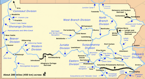
Map of historic Pennsylvania canals
|
|
| Country | United States |
| State | Pennsylvania |
| Physical characteristics | |
| Main source | Wiconisco Creek Millersburg, Dauphin County 381 ft (116 m) 40°32′10″N 76°57′56″W / 40.53611°N 76.96556°W |
| River mouth | Susquehanna River Opposite the mouth of the Juniata River, Dauphin County 335 ft (102 m) 40°24′03″N 77°00′49″W / 40.40083°N 77.01361°W |
| Length | 12 mi (19 km) |
| Basin features | |
| River system | Pennsylvania Canal |
| Original owner | Commonwealth of Pennsylvania |
The Wiconisco Canal was a special water path built in the 1800s in Dauphin County, Pennsylvania. It was about 12 miles (19 km) long. This canal ran along the east side of the Susquehanna River, connecting the towns of Millersburg and Duncan's Island.
Canals like this helped boats move goods. The Wiconisco Canal used 7 special water elevators, called locks, to help boats go up and down a total of 42 feet (13 m). This allowed boats to travel even when the land changed height.
The state government of Pennsylvania started building the canal. A private company finished it in 1845. The canal was mainly used to ship coal and other items from northern Dauphin County to faraway places. Later, a company owned by the Pennsylvania Railroad bought the canal. It kept working until a big flood in 1889 mostly destroyed it.
One important part of the canal, Aqueduct No. 3 near Halifax, is still used today. It acts as a bridge for cars to cross Powell Creek. This historic bridge was added to the National Register of Historic Places in 1988.
Contents
How the Wiconisco Canal Was Built
The state of Pennsylvania began building the Wiconisco Canal around 1837 or 1838. It was planned as an extension of another canal system called the Eastern Division of the Pennsylvania Canal. Samuel Krauss, an engineer for the Eastern Division, designed the Wiconisco Canal.
The plans included building a dam at Clarks Ferry. This dam would make the water deep enough for canal boats to cross the Susquehanna River. They would cross next to the Clarks Ferry Bridge to connect with other canals.
Who Managed the Construction?
After the Eastern Division canal was finished, John P. Rutherford became the construction manager for the Wiconisco project. In 1839, Simon Sallade took over from Rutherford. Sallade divided the canal into 25 sections. This helped keep track of costs, bids, and work details.
Special structures like the locks were planned and built separately. These included a dam on Wiconisco Creek at Millersburg and three aqueducts. An aqueduct is like a bridge that carries water, allowing the canal to cross over a creek or valley.
Aqueduct No. 3: A Special Bridge
Aqueduct No. 3 was the largest of the three aqueducts. It carried the canal over Powell Creek. This important structure was finished in 1840.
Why Did the State Stop Building?
After 1841, the state stopped working on the canal. This happened because they ran out of money. There were money problems in the country, like the panics of 1837 and 1839. Because of this, Pennsylvania could not pay its debts, including money owed for the canal work.
In 1842, the state government allowed a private company, the Wiconisco Canal Company, to take over the project. This company finished the canal, and it started operating in 1845.
Shipping Coal and Other Goods
Under the leadership of Edward Gratz, the main owner, the Wiconisco Canal made good money in the 1850s and 1860s. It shipped a lot of anthracite coal every year. This coal came from mines in the nearby Lykens Valley.
Other things shipped on the canal included timber, farm products, furniture, and building materials. These goods could reach big cities like Philadelphia by connecting to other parts of the Pennsylvania Canal system. In 1871, the canal even shipped railroad iron, which might have helped lead to its eventual closing.
The End of the Canal
Over time, the canal needed expensive repairs, and it became harder to make a profit. In 1871, the Wiconisco Canal Company sold its property to the Pennsylvania Canal Company. This company was a part of the Pennsylvania Railroad.
Shipping coal by boat was cheaper than by train. So, the canal kept working until a big flood in 1889 destroyed much of it. The canal was completely closed in 1890 and never opened again.
Aqueduct No. 3 Today
It is believed that Aqueduct No. 3, near Halifax, continued to be used for land traffic even after the canal was destroyed in the 1890s. This area is narrow, with Peters Mountain on one side and the Susquehanna River on the other. There was no other easy way for people and vehicles to cross Powell Creek.
A state road map from 1928 showed a road, Legislative Route No. 1, crossing the creek on the aqueduct. Today, this road is called Pennsylvania Route 147, and it still uses the old aqueduct as a bridge. The structure, known as the "Bridge in Reed Township," was added to the National Register of Historic Places in 1988 because of its historical importance.
Places to See Along the Canal
| Feature | What it is |
|---|---|
| Millersburg | The town where the canal started in the north. |
| Aqueduct No. 3 | The biggest bridge that carried the canal over Powell Creek. |
| Duncan's Island | The island where the canal ended in the south. |
 | Emma Amos |
 | Edward Mitchell Bannister |
 | Larry D. Alexander |
 | Ernie Barnes |

