Halifax, Pennsylvania facts for kids
Quick facts for kids
Halifax, Pennsylvania
|
|
|---|---|
|
Borough
|
|

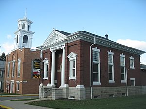
Halifax National Bank
|
|

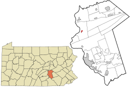
Location in Dauphin County and the U.S. state of Pennsylvania.
|
|
| Country | United States |
| State | Pennsylvania |
| County | Dauphin |
| Settled | 1784 |
| Incorporated | 1785 |
| Government | |
| • Type | Borough Council |
| Area | |
| • Total | 0.34 sq mi (0.87 km2) |
| • Land | 0.34 sq mi (0.87 km2) |
| • Water | 0.00 sq mi (0.00 km2) |
| Elevation | 433 ft (132 m) |
| Population
(2020)
|
|
| • Total | 796 |
| • Density | 2,369.05/sq mi (915.87/km2) |
| Time zone | UTC-5 (Eastern (EST)) |
| • Summer (DST) | UTC-4 (EDT) |
| ZIP code |
17032
|
| Area code(s) | 717 and 223 |
| FIPS code | 42-32032 |
Halifax is a small town, called a borough, located in Dauphin County, Pennsylvania. It became an official town on May 29, 1785. Halifax is built right where Armstrong Creek flows into the big Susquehanna River. In 2020, about 795 people lived there. It is part of the larger Harrisburg–Carlisle area.
A long time ago, a place called Fort Halifax stood near the town along the Susquehanna River. This fort was a temporary stronghold for the Pennsylvania colonial militia during the French and Indian War from 1756 to 1757. Before Europeans settled here, Native American tribes, likely the Susquehannocks, lived in the area. People still find old tools and arrowheads, which shows they were here.
Just outside Halifax, in Halifax Township, you can find the Clemson Island Prehistoric District on Clemson Island. This is an important historical site.
History of Halifax
A special historical landmark near Halifax is the Legislative Route 1 Sycamore Allee. This is a beautiful row of sycamore trees that line both sides of the road south of Halifax and the east side of the road north of town. It was added to the National Register of Historic Places in 2007 because of its historical importance.
Halifax Geography
Halifax is located in the western part of Dauphin County. It sits on the east bank of the Susquehanna River.
Pennsylvania Route 147 runs through the borough. This road goes north about 6 miles (10 km) to Millersburg. It also goes southwest about 7 miles (11 km) to U.S. Route 22 near Duncannon. Another road, Pennsylvania Route 225, goes northeast from Halifax about 9 miles (14 km) to Elizabethville. It also follows PA 147 south out of Halifax, then turns to head south over Peters Mountain to Dauphin, which is about 9 miles (14 km) south of Halifax.
The United States Census Bureau says that Halifax covers a total area of 0.34 square miles (0.87 square kilometers). All of this area is land.
Halifax Population
| Historical population | |||
|---|---|---|---|
| Census | Pop. | %± | |
| 1850 | 436 | — | |
| 1860 | 473 | 8.5% | |
| 1870 | 568 | 20.1% | |
| 1880 | 580 | 2.1% | |
| 1890 | 515 | −11.2% | |
| 1900 | 618 | 20.0% | |
| 1910 | 745 | 20.6% | |
| 1920 | 771 | 3.5% | |
| 1930 | 757 | −1.8% | |
| 1940 | 813 | 7.4% | |
| 1950 | 822 | 1.1% | |
| 1960 | 824 | 0.2% | |
| 1970 | 907 | 10.1% | |
| 1980 | 909 | 0.2% | |
| 1990 | 911 | 0.2% | |
| 2000 | 875 | −4.0% | |
| 2010 | 841 | −3.9% | |
| 2020 | 795 | −5.5% | |
| 2021 (est.) | 794 | −5.6% | |
| U.S. Decennial Census | |||
According to the census from 2000, there were 875 people living in Halifax. These people made up 386 households, and 240 of these were families. Most of the people living in Halifax were White (98.40%).
About 32.6% of the households had children under 18 living with them. Around 43.8% of households were married couples living together. The average household had about 2.27 people, and the average family had about 2.85 people.
The population in Halifax was spread out by age. About 26.1% of the people were under 18 years old. Around 15.7% were 65 years old or older. The average age of people in Halifax was 36 years.
See also
 In Spanish: Halifax (Pensilvania) para niños
 | Laphonza Butler |
 | Daisy Bates |
 | Elizabeth Piper Ensley |


