
Pennsylvania Canal (West Branch Division) facts for kids
Quick facts for kids West Branch Pennsylvania Canal |
|
|---|---|

Bald Eagle Crosscut Canal in Flemington in 2010
|
|

Map of historic Pennsylvania canals
|
|
| Country | United States |
| State | Pennsylvania |
| Physical characteristics | |
| Main source | West Branch Susquehanna River Farrandsville, Clinton County 558 ft (170 m) 41°10′12″N 77°30′57″W / 41.17000°N 77.51583°W |
| River mouth | Susquehanna River Northumberland, Northumberland County 420 ft (130 m) 40°52′55″N 76°47′51″W / 40.88194°N 76.79750°W |
| Length | 73 mi (117 km) |
| Basin features | |
| River system | Pennsylvania Canal |
| Original owner | Commonwealth of Pennsylvania |
The West Branch Division of the Pennsylvania Canal was an important waterway in Pennsylvania. It was like a long, man-made river that helped move goods and people. This canal stretched for about 73 miles (117 km). It connected different towns along the West Branch Susquehanna River.
The canal started in Northumberland, Pennsylvania, where the West Branch Susquehanna River meets the main Susquehanna River. From there, it went north through Muncy. Then, it turned west, passing through towns like Williamsport, Jersey Shore, and Lock Haven. It ended in Farrandsville.
This canal was part of a bigger system called the Pennsylvania Canal. It connected to other canal divisions, allowing goods to travel across Pennsylvania and even to other states.
Contents
Building the Canal
Building the West Branch Canal was a big project. It started in 1828 and was finished in 1835. The canal had 19 special sections called locks. Locks are like water elevators that help boats move up or down between different water levels. These locks helped boats overcome a total height difference of about 140 feet (43 m).
The locks were numbered, starting with Lock No. 13 near Northumberland. They ended with Lock No. 34 near Lock Haven. There were also two "guard locks" and an "outlet lock" to control the water flow.
Originally, there were plans to make the canal even longer. The state wanted to extend it from Farrandsville further up the West Branch Susquehanna River. They even thought about connecting it to the Allegheny River in western Pennsylvania. However, these plans were never finished.
Connecting Canals
Other smaller canals were built to connect to the West Branch Canal, making the transportation network even bigger.
Bald Eagle Crosscut Canal
One important addition was the Bald Eagle Crosscut Canal. This canal was about 4 miles (6.4 km) long. It ran through Lock Haven and Flemington along Bald Eagle Creek. This canal connected the West Branch Canal to another private canal system.
The private canal system was called the Bald Eagle and Spring Creek Navigation. It extended the canal another 22 miles (35 km) to Bellefonte. This allowed boats to travel along Bald Eagle and Spring creeks. Starting in 1837, these canals were used to transport large amounts of pig iron (a type of metal) and bituminous coal (a type of coal) to faraway markets.
Lock Haven Dam
A dam called the Lock Haven Dam (also known as the Dunnstown Dam) was built in the 1800s. Its main purpose was to provide enough water for the West Branch Canal. Canal boats would cross the water behind the dam using a special cable ferry. This ferry moved between Lock No. 35 on the Lock Haven side and Lock No. 34 on the Lockport side.
Other Small Canals
- In 1833, a short canal called the Lewisburg Cut was added. It was about 0.75-mile (1.21 km) long and connected the town of Lewisburg to the main canal system. Lewisburg is about 11 miles (18 km) north of Northumberland.
- The Muncy Cut was another short, private canal, also about 0.75 miles (1.21 km) long. It created a branch into Muncy, which is about 20 miles (32 km) north of Northumberland.
Canal Remnants Today
Today, you can still find parts of the old West Branch Canal along the West Branch Susquehanna River. Stone walls from the canal still stand near Muncy. Other parts of the canal and locks are preserved near Lock Haven.
Since 2005, people have been working to restore and study the Muncy Canal Heritage Park and Nature Trail. This park covers about 11 acres (4.5 ha) and includes parts of the old towpath (a path where horses would pull boats), a lock, a canal wall, and a lock tender's house.
A section of the Bald Eagle Crosscut Canal still has water flowing through it in Flemington. Lock No. 32 has also been preserved in Jersey Shore. These remnants help us remember the important history of these canals.


Images for kids
-
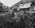
Lock No. 34 and the lock keeper's house at Lockport.
-
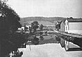
Bald Eagle Crosscut Canal in Lock Haven, around 1898.
-

Lock No. 32 in Jersey Shore in 2012. You can see the old lock parts in a public park.
