
Image: Yakima County Washington Incorporated and Unincorporated areas

Size of this PNG preview of this SVG file: 627 × 600 pixels. Other resolution: 251 × 240 pixels.
Original image (SVG file, nominally 1,150 × 1,100 pixels, file size: 152 KB)
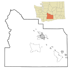
Description: This map shows the incorporated and unincorporated areas in Yakima County, Washington. Based on on File:Yakima_County_Washington_Incorporated_and_Unincorporated_areas_Yakima_Highlighted.svg by Arkyan
Title: Yakima County Washington Incorporated and Unincorporated areas
Credit: Own work
Author: Umbris
Usage Terms: Creative Commons Attribution-Share Alike 3.0
License: CC BY-SA 3.0
License Link: https://creativecommons.org/licenses/by-sa/3.0
Attribution Required?: Yes
Image usage
The following 30 pages link to this image:
- Artesian, Washington
- Ashue, Washington
- Birchfield, Washington
- Blackrock, Washington
- Brownstown, Washington
- Buena, Washington
- Byron, Washington
- Cowiche, Washington
- Donald, Washington
- E. William Brackett House
- Emerald, Washington
- Farron, Washington
- Flint, Washington
- Fruitvale, Washington
- Givens Corner, Washington
- Goose Prairie, Washington
- Gromore, Washington
- Holtzinger, Washington
- Liberty, Yakima County, Washington
- Lichty, Washington
- Midvale, Washington
- Nass, Washington
- Outlook, Washington
- Parker, Washington
- Sawyer, Washington
- Venner, Washington
- Weikel, Washington
- Wenas, Washington
- Wiley City, Washington
- Yethonat, Washington

All content from Kiddle encyclopedia articles (including the article images and facts) can be freely used under Attribution-ShareAlike license, unless stated otherwise.