Indigenous Peoples Atlas of Canada facts for kids

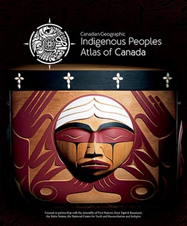
Cover of the volume Truth and Reconciliation, one of four books in the Atlas
|
|
| Country | Canada |
|---|---|
| Language | English, French |
| Subject | Indigenous peoples in Canada |
| Genre | Encyclopedia |
| Publisher | Canadian Geographic |
|
Publication date
|
2018 |
The Indigenous Peoples Atlas of Canada (French: Atlas des peuples autochthones du Canada) is a special learning tool. It is available in both English and French. The Royal Canadian Geographical Society created it, and Canadian Geographic published it. The Government of Canada helped pay for it.
This atlas was made to help answer important requests from the Truth and Reconciliation Commission of Canada. One of these requests was to create school materials that fit the cultures of Indigenous students. The atlas shares information about Indigenous lands, languages, communities, and cultures. It also covers important topics like the Canadian Indian residential school system, racism, and cultural appropriation.
Contents
What is the Indigenous Peoples Atlas?
The Atlas is more than just a book. It includes a set of four books and an online website. There are also big floor maps, which are like giant maps you can walk on. You can also find smaller maps, teaching guides, and lesson plans for teachers.
Exploring the Atlas Resources
One of the floor maps is as big as a school gym! It measures about 11 by 8 meters (36 by 26 feet). Around the edge of this large map, you can see a timeline. This timeline shows important events in Indigenous history from about 2000 BCE to 2017.
To create the Atlas, many groups worked together. These included organizations that represent Indigenous peoples in Canada. Some of these groups are the Assembly of First Nations, Indspire, Inuit Tapiriit Kanatami, and the Métis National Council. The National Centre for Truth and Reconciliation also helped. Some of the people who edited the Atlas are also members of Indigenous groups.
The Four Books of the Atlas
The Atlas has four main books. Each book focuses on a different part of Indigenous history and culture:
- Inuit: This book is all about the Inuit people.
- Métis: This book tells the story of the Métis people.
- First Nations: This book covers the history and cultures of the First Nations.
- Truth and Reconciliation: This book explains the history of residential schools. It also talks about how people are working to make things right and legal actions taken. This book also has many maps.
Visual Design of the Atlas
The look and feel of the Atlas were created by Vincent Design. This company was started by Shaun Vincent, a Métis designer. The Atlas logo looks like a compass. It is a round shape that stands for guidance. It also includes ideas from different Indigenous groups across Canada, like a medicine wheel.
History of the Atlas Project
The Indigenous Peoples Atlas of Canada was officially launched in Ottawa on June 21, 2018. Many important people were there. These included John G. Geiger, who leads the Royal Canadian Geographical Society. Mélanie Joly, a government minister, was also present. Leaders from First Nations, Inuit, and the Métis Nation attended, along with Indigenous artists.
Another launch event happened in Toronto in August 2018. This event included leaders from the Mississaugas of the Credit First Nation. Some of the editors who helped create the Atlas were also there.
How the Project Started
The idea for the Atlas began in 2016. Mr. Geiger met with Carolyn Bennett, another government minister. In June 2017, Minister Joly announced that the Government of Canada would give over $2 million to the Royal Canadian Geographical Society. This money helped develop the Atlas. Part of the funding came from the Canada 150 fund, which celebrated Canada's 150th birthday.
Two magazines, Canadian Geographic and Géographica, dedicated special issues to the Atlas project. The book set will be sold by Kids Can Press. Mr. Geiger has said that the atlas and maps will be translated into many of Canada's Indigenous languages.
See also
 | Emma Amos |
 | Edward Mitchell Bannister |
 | Larry D. Alexander |
 | Ernie Barnes |

