Ingeegoodbee River facts for kids
Quick facts for kids Ingeegoodbee |
|
|---|---|

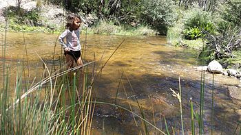
A child crossing the Ingeegoodbee River, Australia
|
|
| Other name(s) | Ingeegoodbee Creek |
| Country | Australia |
| States | New South Wales, Victoria |
| Region | Australian Alps (IBRA), Snowy Mountains, Victorian Alps |
| Local government areas | Snowy Monaro Regional Council, East Gippsland |
| Physical characteristics | |
| Main source | Snowy Mountains south of Thredbo, Snowy Mountains, New South Wales 1,340 m (4,400 ft) 36°45′S 148°15′E / 36.750°S 148.250°E |
| River mouth | confluence with the Suggan Buggan River south of the Black-Allan Line, Victorian Alps, Victoria 514 m (1,686 ft) 36°52′29″S 148°19′28″E / 36.87472°S 148.32444°E |
| Length | 31 km (19 mi) |
| Basin features | |
| River system | Snowy River catchment |
| Tributaries |
|
| National parks | Kosciuszko NP, Alpine NP |
The Ingeegoodbee River is a cool waterway in Australia. It flows through the beautiful Alpine mountains. You can find it in both New South Wales and Victoria. This river is a perennial river, which means it flows all year round. It is an important part of the larger Snowy River system.
River's Journey and Features
The Ingeegoodbee River begins high up in the Snowy Mountains. This area is part of the Kosciuszko National Park in New South Wales. It starts south of a town called Thredbo.
The river flows generally towards the southeast and then southwest. It crosses a special line called the Black-Allan Line. This line helps mark the border between Victoria and New South Wales. Along its way, one smaller stream, called a tributary, joins the Ingeegoodbee River.
Finally, the Ingeegoodbee River meets another river, the Suggan Buggan River. This meeting point is called a confluence. It happens inside the Alpine National Park in Victoria. Over its 31-kilometer (about 19-mile) course, the river drops about 826 meters (about 2,710 feet) in height.
 | John T. Biggers |
 | Thomas Blackshear |
 | Mark Bradford |
 | Beverly Buchanan |


