Inglewood, Queensland facts for kids
Quick facts for kids InglewoodQueensland |
|||||||||||||||
|---|---|---|---|---|---|---|---|---|---|---|---|---|---|---|---|
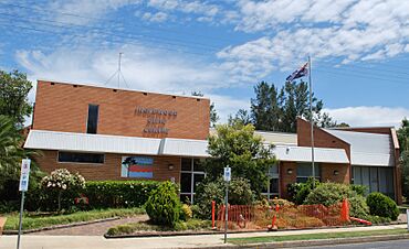
Inglewood Civic Centre
|
|||||||||||||||
| Population | 936 (2021 census) | ||||||||||||||
| • Density | 2.6204/km2 (6.787/sq mi) | ||||||||||||||
| Established | 1862 | ||||||||||||||
| Postcode(s) | 4387 | ||||||||||||||
| Elevation | 280 m (919 ft) | ||||||||||||||
| Area | 357.2 km2 (137.9 sq mi) | ||||||||||||||
| Time zone | AEST (UTC+10:00) | ||||||||||||||
| Location |
|
||||||||||||||
| LGA(s) | Goondiwindi Region | ||||||||||||||
| State electorate(s) | Southern Downs | ||||||||||||||
| Federal Division(s) | Maranoa | ||||||||||||||
|
|||||||||||||||
Inglewood is a country town and locality in the Goondiwindi Region of Queensland, Australia. It's a small community with a population of 936 people, according to the 2021 census.
Contents
Exploring Inglewood's Location
Inglewood is located in the southern part of the Darling Downs. It sits right between the larger towns of Warwick and Goondiwindi. You can find it on the Cunningham Highway, about 150 km (93 mi) south-west of Toowoomba.
The town is part of the Border Rivers area, which has many waterways. Just north of Inglewood, the Macintyre Brook and Canning Creek meet. The brook then flows almost completely around the town.
What Inglewood Produces
Inglewood is known for its farming and timber. A newer industry in the area is growing olives. Other long-standing industries include raising sheep and cattle. Farmers also grow grains like wheat. Timber harvesting is another important activity here. In the past, growing tobacco was also common around Inglewood.
Inglewood's Past: A Look Back
The land around Inglewood has a rich history. The Bigambul people are the traditional owners of this area. Their language, Bigambul, was spoken across the region. This includes towns like Goondiwindi and Texas.
Early European Discoveries
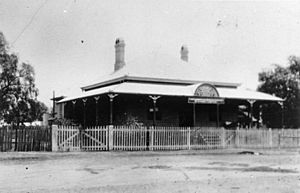
An English botanist and explorer named Allan Cunningham was the first European to explore the Inglewood area. He passed through in May 1827. The very first settlement was an inn called Browns Inn. It was an important stop for bullock teams travelling west. This inn opened in the late 1850s.
How Inglewood Got Its Name
In April 1862, a town was planned on the higher ground north of Macintyre Brook. The surveyor, L.F. Landsbergon, changed the name from Pariagna to Inglewood. He combined an Aboriginal word, ingol, meaning cypress pine, with the English word wood. This referred to a group of trees nearby. The Inglewood Post Office opened a few years later, on 16 September 1866.
Growing Up: Schools and Churches
Inglewood State School first opened its doors on 13 February 1872. It started as a primary school and added a secondary department in 1960. An Anglican church was built in 1894, and a Catholic church followed in 1902.
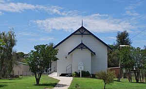
The Inglewood Presbyterian Church was officially opened in 1906. In 1951, St Maria Goretti's School opened. It was named after a young Italian saint, Maria Goretti. This was a popular choice for the many Italian families who had moved to the area.
The Arrival of the Railway
The railway reached Inglewood on 8 July 1907. This connected the town to Thane. The railway station was first called 'Pariagna' but changed to Inglewood. A year later, the line was extended to Goondiwindi. Inglewood became an important rail junction when a line to Texas opened. This line helped transport goods like fuel and ore. However, the Texas rail line closed in 1994 because fewer people used it. Trucks became the main way to move freight.
Important Buildings and Changes
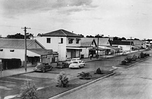
A hospital was built in Inglewood in 1921. The Inglewood War Memorial was also dedicated in 1922. In 1925, a directory showed that Inglewood had four hotels, two sawmills, a picture show, and many other shops.
Coolmunda Dam was built in 1968. This dam created Lake Coolmunda, which is now a popular spot. The Inglewood Public Library building opened in 1996. Inglewood used to be the main town for the Shire of Inglewood. But in 2008, it became part of the larger Goondiwindi Region.
Learning in Inglewood
Inglewood has two schools for younger students.
Inglewood State School
Inglewood State School is a government school for both boys and girls. It teaches students from Early Childhood up to Year 10. In 2017, it had 141 students. The school also has a special education program. You can find it on Chilcott Street (28°24′58″S 151°04′37″E / 28.4161°S 151.0770°E).
St Maria Goretti School
St Maria Goretti School is a Catholic primary school. It teaches boys and girls from Prep to Year 6. In 2017, it had 23 students. The school is located on Elizabeth Street (28°24′47″S 151°04′49″E / 28.4130°S 151.0803°E).
Since Inglewood schools only go up to Year 10, older students often travel. Many take a bus to Goondiwindi or attend boarding schools in bigger cities like Warwick, Toowoomba, and Brisbane to finish Years 11 and 12.
What to Do and See in Inglewood
Inglewood has several places for fun and community activities.
Community Facilities
The town has a public library where you can borrow books. The Civic Centre hosts local events and plays. For sports, there are sports grounds, tennis courts, a swimming pool, a golf course, and a bowling club. The public library is inside the Civic Centre, at the corner of Albert and Elizabeth Streets.
Churches in Town
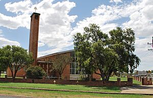
Our Lady of the Southern Cross Catholic Church is on the corner of George and Elizabeth Streets (28°24′49″S 151°04′50″E / 28.4136°S 151.0806°E). The Inglewood Presbyterian Church is located at 15 Regent Street.
Fun Attractions
The main attraction near Inglewood is Lake Coolmunda. It's about 13 km (8.1 mi) east of town. The lake is a great place for water skiing, sailing, canoeing, fishing, camping, and watching birds. The Inglewood & District Historical Society also has a small museum. It's called the Inglewood Heritage Centre. Here, you can learn about the history of the area. This includes how people explored and settled the land, and how farming and transport developed.
Inglewood's Weather
Inglewood has a humid subtropical climate. This means it has warm, humid summers and mild winters.
| Climate data for Inglewood (Inglewood Forest, 2000–2014) | |||||||||||||
|---|---|---|---|---|---|---|---|---|---|---|---|---|---|
| Month | Jan | Feb | Mar | Apr | May | Jun | Jul | Aug | Sep | Oct | Nov | Dec | Year |
| Record high °C (°F) | 42.0 (107.6) |
40.8 (105.4) |
40.0 (104.0) |
33.9 (93.0) |
31.6 (88.9) |
27.0 (80.6) |
26.3 (79.3) |
35.2 (95.4) |
36.0 (96.8) |
38.0 (100.4) |
41.6 (106.9) |
41.2 (106.2) |
42.0 (107.6) |
| Mean daily maximum °C (°F) | 33.2 (91.8) |
32.2 (90.0) |
30.4 (86.7) |
27.3 (81.1) |
22.4 (72.3) |
19.0 (66.2) |
18.6 (65.5) |
21.0 (69.8) |
25.3 (77.5) |
28.0 (82.4) |
30.1 (86.2) |
31.5 (88.7) |
26.6 (79.9) |
| Mean daily minimum °C (°F) | 18.7 (65.7) |
18.0 (64.4) |
16.2 (61.2) |
13.1 (55.6) |
8.8 (47.8) |
6.7 (44.1) |
5.6 (42.1) |
6.9 (44.4) |
10.6 (51.1) |
13.1 (55.6) |
15.9 (60.6) |
17.7 (63.9) |
12.6 (54.7) |
| Record low °C (°F) | 11.9 (53.4) |
10.7 (51.3) |
7.5 (45.5) |
2.8 (37.0) |
−2.0 (28.4) |
−2.0 (28.4) |
−2.7 (27.1) |
−1.9 (28.6) |
−2.0 (28.4) |
3.5 (38.3) |
4.6 (40.3) |
8.6 (47.5) |
−2.7 (27.1) |
| Average rainfall mm (inches) | 72.3 (2.85) |
54.5 (2.15) |
63.5 (2.50) |
27.4 (1.08) |
28.6 (1.13) |
33.3 (1.31) |
28.7 (1.13) |
24.3 (0.96) |
34.0 (1.34) |
49.7 (1.96) |
79.9 (3.15) |
97.3 (3.83) |
587.3 (23.12) |
| Average precipitation days | 7.4 | 7.2 | 6.8 | 4.7 | 4.6 | 7.5 | 5.9 | 5.0 | 5.8 | 7.2 | 8.7 | 8.5 | 79.3 |
| Average relative humidity (%) | 32 | 36 | 35 | 35 | 38 | 46 | 42 | 33 | 30 | 27 | 34 | 34 | 35 |
| Source: Bureau of Meteorology | |||||||||||||
 | Selma Burke |
 | Pauline Powell Burns |
 | Frederick J. Brown |
 | Robert Blackburn |


