
Inishcoo facts for kids
|
Native name:
Inis Cú
|
|
|---|---|

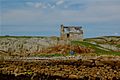
View of the NW end of Inishcoo
|
|

Inishcoo
Location in island of Ireland
|
|
| Geography | |
| Location | Atlantic Ocean |
| Coordinates | 54°59′13″N 8°27′50″W / 54.98694°N 8.46389°W |
| Area | 0.50 km2 (0.19 sq mi) |
| Administration | |
| Province | Ulster |
| County | Donegal |
Inishcoo (which is called Inis Cú in Irish) is a small island. It is located off the coast of County Donegal in Ireland. The closest town on the mainland is Burtonport. Inishcoo is also known as a townland, which is a traditional way of dividing land in Ireland.
Exploring Inishcoo's Location
Inishcoo island is about 1.5 kilometers (or about a mile) east of a bigger island called Arranmore. It is also southwest of a smaller island named Eighter. A special bridge for walking connects Inishcoo and Eighter. Both islands have lovely sandy beaches, which are great for visiting!
The middle part of Inishcoo is mostly rocky. It is made of a hard stone called granite. There is also a small lake on the island.
A Look at Inishcoo's Past
A small group of people used to live on Inishcoo island. This was especially true during the early 1900s. Today, some of the old houses are used as holiday homes. The largest building used to be a coast-guard station. It is located in the southwestern part of the island.
The number of people living on Inishcoo changed a lot over the years. This table shows how the population changed:
| Historical population | ||||||||||||||||||||||||||||||||||||||||||||||||||||||||||||||||||||||||||||||||
|---|---|---|---|---|---|---|---|---|---|---|---|---|---|---|---|---|---|---|---|---|---|---|---|---|---|---|---|---|---|---|---|---|---|---|---|---|---|---|---|---|---|---|---|---|---|---|---|---|---|---|---|---|---|---|---|---|---|---|---|---|---|---|---|---|---|---|---|---|---|---|---|---|---|---|---|---|---|---|---|---|
|
|
|
||||||||||||||||||||||||||||||||||||||||||||||||||||||||||||||||||||||||||||||
| Source: | ||||||||||||||||||||||||||||||||||||||||||||||||||||||||||||||||||||||||||||||||
Photo gallery
-
A derelict building on Inishcoo
-
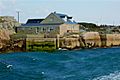
Another house as seen from the Arranmore ferry
-
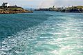
The channel dividing Rutland from Inishcoo (on the left)


