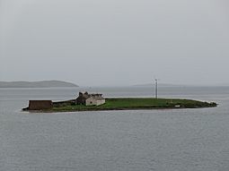
Inner Holm facts for kids
| Norse name | Unknown |
|---|---|
| Meaning of name | inner rounded islet |
 Inner Holm from MV Hamnavoe |
|
| OS grid reference | HY259087 |
| Coordinates | 58°57′36″N 3°17′20″W / 58.96°N 3.289°W |
| Physical geography | |
| Island group | Orkney |
| Area | c. 2 hectares (4.9 acres) |
| Highest elevation | 16 m (52 ft) |
| Administration | |
| Sovereign state | United Kingdom |
| Country | Scotland |
| Council area | Orkney Islands |
| Demographics | |
| Population | 1 |
Inner Holm is a tiny island located in Stromness harbour, which is a port in Scotland. It's one of the many beautiful Orkney islands.
Where is Inner Holm?
Inner Holm is located about 350 meters (1,150 feet) east of the main harbour in Stromness. When the tide is low, you can actually walk to it from the Orkney Mainland shore across the bay.
There's another, slightly bigger island called Outer Holm to the south. Inner Holm also connects to Outer Holm when the tide is low. To the east of Inner Holm, you'll find the waters of Cairston Roads, which are part of the famous Scapa Flow.
Island Life
Even though Inner Holm is small, someone lives there! According to the 2011 census, one person lived on the island. This was also true in 2001.
There are some buildings at the north end of the island. A stony path, called a causeway, lets vehicles drive onto the island when the tide is low. On the west side of Inner Holm, there's a small wind turbine. This turbine helps to create electricity, possibly for the island's resident.
A Ship's Story
On January 23, 1857, a ship named the SS Gnome had a bit of trouble. It ran aground, meaning it got stuck, while trying to enter Stromness harbour. This happened on the "Holme side," which means near Inner Holm. Luckily, the ship was successfully pulled free from its position between Inner Holm and Outer Holm.
 | Misty Copeland |
 | Raven Wilkinson |
 | Debra Austin |
 | Aesha Ash |

