Inninmore Bay facts for kids
Quick facts for kids Inninmore Bay |
|
|---|---|

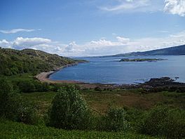
Inninmore Bay. Facing south-east down the sound of Mull. Craignure can be seen on Mull
|
|
| Location | NM72244142 |
| Coordinates | 56°30′35″N 5°42′11″W / 56.5096°N 5.70314563°W |
| Type | bay |
| River sources | Dearg Allt |
| Islands | Eilean Rubha an Ridire, Glas Eileanan |
Inninmore Bay is a small, shallow bay located on the western coast of Scotland. It is part of the Morvern peninsula in Lochaber. The bay stretches for about 1.74 miles and faces towards the south-east. It is located about three miles east-south-east from the entrance to Loch Aline.
Contents
Life in Inninmore Bay
Inninmore Bay was once home to a small village. In 1770, five houses were lived in here. By 1841, only two houses were still occupied. Just one house remained in use by 1851.
A new cottage was built in the bay in 1862. However, it was left empty by 1939. The outlines of five or six more old buildings can still be seen. These were likely abandoned before 1755. Today, two of the original cottages have been fixed up and are used again.
Exploring Inninmore Bay's Surroundings
Directly west of Inninmore Bay is the Sound of Mull. This is a narrow stretch of water that separates the mainland from the Isle of Mull. The Sound runs from Aulston Point and Tobermory in the north down to Duart Point on Mull in the west.
To the north-west, you can partly see Ardtornish Bay from Inninmore Bay. Ardtornish Point marks the northern edge of Ardtornish Bay. Looking inland to the north-east, the land is mostly flat for about 200 to 300 meters from the bay. After that, it rises steeply to a high, flat area. This plateau continues inland for about 18 kilometers. It follows the curve of Loch Linnhe to the south. Further north, it meets a natural break in the land that holds Loch Sunart. To the east, you'll find Glen Tarbert and the A861 road.
Islands and Views from the Bay
At the southern end of Inninmore Bay, you can see several islands. They appear almost in a straight line across to Mull. The first island is Eilean Rubha an Ridire. Next is Glas Eileanan, which has a lighthouse in the middle of the channel. After that, you'll see the rocks of Sgeir nan Goghar. Finally, there's a rocky outcrop on Mull itself called Sgeir Mhic Chomhain.
Craignure Bay on Mull is directly south of this rocky outcrop. You can see Craignure Bay very clearly from Inninmore Bay. This is where the ferry from Oban arrives on Mull.
Ancient Fish Traps
Inninmore Bay is known for an old tidal stone fish trap. This trap was built to catch fish when the tide went out. It has a radius of 54 meters and forms a simple semicircle. It is centered around a small stream that flows into the bay.
Local Quarries
Near the mouth of the Dearg Allt burn, there are three old sandstone quarries. A quarry is a place where stone is dug out of the ground. These quarries were used for over 500 years, starting in the 13th century. It seems they stopped working sometime in the 19th century.


