Integrated Marine and Coastal Regionalisation of Australia facts for kids
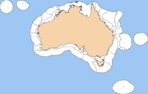
The Integrated Marine and Coastal Regionalisation of Australia (IMCRA) is a way to divide Australia's ocean waters into different natural areas. Think of it like drawing maps for the ocean! These maps help us understand and protect the amazing marine life and environments found in Australia's Exclusive Economic Zone (EEZ). The EEZ is a special area of ocean where Australia has rights to explore and use marine resources.
The latest version of this mapping system is called IMCRA Version 4.0, released in 2008.
IMCRA actually creates two main types of ocean maps:
- Benthic bioregionalisation: This map focuses on the seafloor. It looks at where different bottom-dwelling fish live and the physical features of the ocean floor, like mountains or plains.
- Pelagic bioregionalisation: This map focuses on the water itself. It considers things like water temperature, currents, and where different swimming fish species are found.
Contents
Mapping the Seafloor (Benthic)
The seafloor map is made up of three different layers, each showing more detail:
- Provincial Bioregions: These are large areas of the EEZ, like big provinces on land. They are based on where different bottom-dwelling fish species live. In IMCRA 4.0, there are 41 of these regions. Some are called "provinces" and others are "transitions" (areas where different provinces meet).
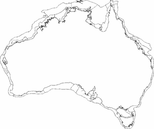
- Meso-scale Regions: These are smaller, more detailed areas within the continental shelf (the shallow part of the ocean near the coast). They are defined by both living things and physical features, as well as how far they are from the shore. IMCRA 4.0 has 60 of these meso-scale regions.
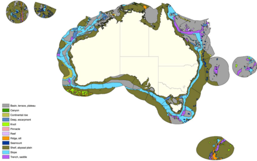
- Geomorphic Units: These are the smallest and most detailed areas. They are based on the shape and features of the ocean floor, like canyons, plains, or ridges. There are 1,134 tiny geomorphic units, which are then grouped into 14 main types.
Mapping the Water (Pelagic)
The pelagic map divides the continental shelf into four main "provinces" based on the types and numbers of swimming fish species.
For the deeper offshore waters, IMCRA looks at the water in three dimensions. It considers things like water temperature, saltiness, how water moves (currents), and how much energy is in the water. This helps scientists understand different "water masses" where specific marine life might thrive.
Ocean Zones: Provincial Bioregions
IMCRA 4.0 has many provincial bioregions. These are large areas that share similar types of marine life and ocean conditions. One interesting example is the Southwest Shelf Transition.
- Southwest Shelf Transition: This special area stretches along the continental shelf from near Perth to Geraldton in Western Australia. It covers about 27,000 square kilometers. The water depth here ranges from zero to almost 300 meters. This region is like a natural meeting point, or "transition zone," for many different species. It's where some warm-water species reach their southern limit, and some cooler-water species reach their northern limit. This makes it a very diverse and important area for marine life!
Smaller Ocean Zones: Benthic Meso-scale Regions
These are more detailed areas, especially on the continental shelf. They help scientists understand smaller differences in marine environments. Some examples include:
- Abrolhos Islands (ABR)
- Arafura (ARA)
- Shark Bay (SBY)
- Ningaloo (NIN)
- Torres Strait (TS)
Understanding the Ocean Floor: Geomorphic Units
The shape of the ocean floor is very important for marine life. Just like different animals live in mountains versus flat plains on land, different marine species live on different parts of the seabed.
There are 1,334 detailed "geomorphic units" in Australia's waters, grouped into 14 main types. These units describe distinct features of the ocean floor. For example, some areas are flat plains, while others have steep canyons.
Scientists use special maps that show ocean depth (called bathymetric models) to identify these features. The shape of the seafloor helps predict what kinds of species will live there. For instance, you'll find different creatures on a gently sloping terrace compared to those living inside a steep submarine canyon.
Types of Ocean Floor Features
Here are some of the main types of geomorphic features found in Australia's oceans:
- Apron: A gently sloping, smooth area, usually at the bottom of a steeper slope, covered mostly by sediment.
- Bank, sandbank: A shallow area or submerged mound of sand in the sea, which might even show above the water at low tide.
- Basin; terrace; plateau:
- Basin: A bowl-shaped dip in the deep seafloor.
- Terrace: A relatively flat surface that slopes gently, often with steeper slopes on either side.
- Plateau: A large, flat or nearly flat area that drops off sharply on one or more sides.
- Canyon: A narrow, deep valley with steep sides, usually found on continental slopes.
- Continental rise: A gently sloping area at the base of the continental slope, where sediments collect.
- Deep; escarpment:
- Deep: Very deep parts of the ocean, usually more than 6,000 meters deep.
- Escarpment: A long, steep slope that separates two flatter areas.
- Knoll: A relatively small, isolated, rounded hill on the seafloor.
- Pinnacle: A tall, tower-shaped rock or coral formation that might even stick out of the water. It can be a danger to boats.
- Reef: A rock formation at or near the sea surface that can be a hazard to boats.
- Ridge; sill:
- Ridge: A long, narrow underwater mountain range with steep sides.
- Sill: An underwater barrier that is relatively shallow, limiting water movement between deeper basins.
- Seamount: A large, isolated underwater mountain that rises more than 1,000 meters from the seafloor, usually cone-shaped.
- Shelf; abyssal plain:
- Shelf: The gently sloping, flatter area right next to a continent or island.
- Abyssal plain: A very deep, flat area of the ocean floor.
- Slope: The sloped area that goes from the edge of the continental shelf down to the deeper ocean.
- Trench; saddle:
- Trench: A very long, narrow, and extremely deep depression in the seafloor with steep sides.
- Saddle: A broad, pass-like dip in a ridge or between two seamounts, shaped like a riding saddle.
 | DeHart Hubbard |
 | Wilma Rudolph |
 | Jesse Owens |
 | Jackie Joyner-Kersee |
 | Major Taylor |


