
Ningaloo Coast facts for kids
| UNESCO World Heritage Site | |
|---|---|
 |
|
| Location | Western Australia, Australia |
| Criteria | Natural: (vii), (x) |
| Inscription | 2011 (35th Session) |
| Area | 705,015 ha (1,742,130 acres) |
The Ningaloo Coast is an amazing place in Western Australia. It's a special area called a World Heritage Site. This means it's so important that it's protected by the UNESCO.
The Ningaloo Coast is about 1,200 kilometres (750 mi) north of Perth. It stretches along the Indian Ocean. The most famous part is the Ningaloo Reef. This reef is 260 kilometres (160 mi) long! It's Australia's biggest "fringing reef". A fringing reef grows very close to the coastline. This makes it easy to visit! The Muiron Islands are also part of this special coastal area.
The name "Ningaloo" comes from the Wajarri language of the Aboriginal people. It means "promontory", "deepwater", or "high land jutting into the sea". The Yamatji people have lived here for over 30,000 years.
Contents
Discovering the Ningaloo Coast World Heritage Site
The Ningaloo Coast became a World Heritage Site in 2011. This means it's recognized as a very important natural place for everyone to protect. The protected area includes the Ningaloo Reef and the land next to it.
Some of the areas included are:
- The Ningaloo Marine Park (Commonwealth waters) (which covers the ocean)
- The Cape Range National Park (which covers the land)
- Other coastal parks like Jurabi and Bundegi Coastal Parks.
In 1987, the reef and its waters were first named the Ningaloo Marine Park. This was an important step to protect its unique marine life.
Amazing Animals of Ningaloo Reef
The Ningaloo Reef is famous for its incredible sea creatures. It's especially known for whale sharks. These gentle giants visit the reef from March to June every year.
During winter, many other animals travel through the reef's waters. You might see dolphins, dugongs, manta rays, and even humpback whales!
The beaches along the reef are vital nesting spots for sea turtles. Loggerhead, green, and hawksbill turtles lay their eggs here. They also rely on the reef for food.
The Ningaloo Reef is home to a huge variety of life:
- Over 500 types of fish
- More than 300 kinds of coral
- About 600 types of molluscs (like clams and snails)
- Many other small sea animals called marine invertebrates.
In some places, the reef is less than 0.5 kilometres (0.31 mi) from the shore. This makes it super easy for people to go snorkeling or diving right from the beach! Scientists have even found new types of sponges in the deeper waters. In 2015, a short-nosed sea snake, which was thought to be extinct, was found here!
Exploring the Ningaloo Coast's Protected Areas
The Ningaloo World Heritage Area includes several national parks and reserves. These places help protect the unique environment.
National Parks and Reserves
- Bundegi Coastal Park
- Cape Range National Park
- Jurabi Coastal Park
- Ningaloo Marine Park (Commonwealth waters)
- Ningaloo Marine Park (State waters)
Islands of the World Heritage Area
- North Muiron Island
- South Muiron Island
Marine Park Zones
The Ningaloo Marine Park is divided into different zones. Each zone has special rules to protect the marine life. Some of these zones are:
- Bundegi Sanctuary Zone
- Murat Sanctuary Zone
- Lighthouse Bay Sanctuary Zone
- Jurabi Sanctuary Zone
- Tantabiddi Sanctuary Zone
- Mangrove Sanctuary Zone
- Lakeside Sanctuary Zone
- Mandu Sanctuary Zone
- Osprey Sanctuary Zone
- Winderabandi Sanctuary Zone
- Cloates Sanctuary Zone
- Bateman Sanctuary Zone
- Maud Sanctuary Zone
- Pelican Sanctuary Zone
- Cape Farquhar Sanctuary Zone
- Gnaraloo Bay Sanctuary Zone
- 3 Mile Sanctuary Zone
- Turtles Sanctuary Zone
- South Muiron Conservation Area
- North Muiron Conservation Area
- Sunday Island Conservation Area
Weather on the Ningaloo Coast
The Bureau of Meteorology uses the Ningaloo Coast as a special area for weather forecasts. This helps people know what the weather will be like for their visits and activities.
Images for kids
-
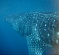
A whale shark swimming near the Ningaloo Coast.
-
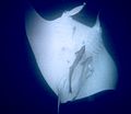
A manta ray with remoras at Ningaloo Reef.
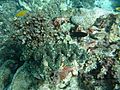
-
Part of the coral reef underwater in 2012.
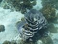
-
A large clam underwater in 2012.
-
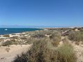
The Ningaloo Coastline in 2012.
-
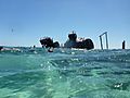
Divers exploring a ship wreck next to the coral reef.
-
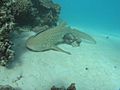
A zebra shark on the reef in 2007.
-

Cape Range National Park and Ningaloo Reef from the air.
-
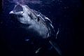
Whale sharks


See also
 In Spanish: Costa de Ningaloo para niños
