Isla del Rey, Chile facts for kids

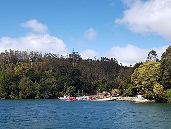
View of Isla del Rey from Valdivia River
|
|
| Geography | |
|---|---|
| Coordinates | 39°53′S 73°19′W / 39.883°S 73.317°W |
| Adjacent bodies of water | Valdivia River |
| Administration | |
|
Chile
|
|
| Region | Los Ríos |
| Province | Valdivia |
| Commune | Corral |
Isla del Rey (which means King's Island in Spanish) is a large river island in the Los Ríos Region of Chile. It is the biggest island in this region. The island is found close to where the Valdivia River flows into Corral Bay.
The island is surrounded by water on all sides. To the east, south, and southwest, the Tornagaleones River separates it from the mainland. To the north, the Valdivia River forms its boundary. Nearby, to the east, you can find Guacamayo Island.
What Does Isla del Rey Look Like?
In 1899, a book called Diccionario Geográfico de la República de Chile described Isla del Rey. It said the island was "somewhat mountainous" and "high." It also mentioned that the island had "some forest" and "various streams" that flowed down to its edges.
How Did Isla del Rey Get Its Name?
Isla del Rey has had two names over time. When the Spanish first arrived in Chile in the mid-1500s, the island was known as isla de Diego Ramírez. This name came from an early Spanish settler. Later, in the mid-1600s, the Spanish took control of the area again. After this, the island got its current name, Isla del Rey, meaning King's Island.
See also
 In Spanish: Isla del Rey (Chile) para niños
 | Jackie Robinson |
 | Jack Johnson |
 | Althea Gibson |
 | Arthur Ashe |
 | Muhammad Ali |

