
Island Lake (Manitoba) facts for kids
Quick facts for kids Island Lake |
|
|---|---|

St. Theresa Point on Island Lake
|
|

Island Lake
Location in Manitoba
|
|
| Location | Division No. 22, Northeastern Manitoba |
| Coordinates | 53°47′N 94°25′W / 53.783°N 94.417°W |
| Primary outflows | Island Lake River |
| Catchment area | 20,000 km2 (7,700 sq mi) |
| Basin countries | Canada |
| Max. length | 85 km (53 mi) |
| Surface area | 1,223 km2 (472 sq mi) |
| Average depth | 20.1 m (66 ft) |
| Max. depth | 59.4 m (195 ft) |
| Residence time | 7.76 years |
| Shore length1 | 745 km (463 mi) |
| Surface elevation | 227 m (745 ft) |
| Settlements | Garden Hill, Island Lake, St. Theresa Point, Wasagamack |
| 1 Shore length is not a well-defined measure. | |
Island Lake is a large lake in northeastern Manitoba, Canada. It is located very close to the border with Ontario. The lake covers a huge area of 1,223 square kilometres (472 sq mi). This makes it the 6th largest lake in the province of Manitoba.
Island Lake is part of the Hayes River water system. The Island Lake River flows north from the lake. It eventually reaches Gods Lake, then Gods River, and finally the Hayes River. A special monument at the east end of Island Lake helps mark the boundary between Ontario and Manitoba.
Communities on Island Lake
Several communities are located around Island Lake. These include First Nations communities and a northern settlement. The main communities are Wasagamack, St. Theresa Point, and Garden Hill. There is also a smaller northern settlement called Island Lake.
In 2011, the total population of these communities was 7,120 people. Wasagamack had 1,411 residents. St. Theresa Point was home to 2,871 people. Both of these communities are on the western side of the lake. About 18 km (11 miles) to the east, across the bay, are Garden Hill and the settlement of Island Lake. Garden Hill had 2,776 residents. The Island Lake settlement had 62 people and is built on several islands.
Climate Around Island Lake
The area around Island Lake experiences a wide range of temperatures. Winters are very cold, with average temperatures often below -20 degrees Celsius. The coldest temperature ever recorded was -45 degrees Celsius in January.
Summers are much warmer and pleasant. The average temperature in July is about 17.5 degrees Celsius. However, it can get quite hot, with the highest recorded temperature being 37.3 degrees Celsius in June.
The region also gets a fair amount of rain and snow. Most of the precipitation falls during the summer months. July and August are usually the wettest months.
| Climate data for Island Lake | |||||||||||||
|---|---|---|---|---|---|---|---|---|---|---|---|---|---|
| Month | Jan | Feb | Mar | Apr | May | Jun | Jul | Aug | Sep | Oct | Nov | Dec | Year |
| Record high °C (°F) | 5.9 (42.6) |
7.5 (45.5) |
16.2 (61.2) |
29.2 (84.6) |
32.2 (90.0) |
37.3 (99.1) |
35 (95) |
32.5 (90.5) |
30.4 (86.7) |
21.7 (71.1) |
15 (59) |
4.4 (39.9) |
37.3 (99.1) |
| Mean daily maximum °C (°F) | −17.7 (0.1) |
−12.4 (9.7) |
−3.8 (25.2) |
5.6 (42.1) |
13.7 (56.7) |
19.5 (67.1) |
22.5 (72.5) |
21.1 (70.0) |
13.5 (56.3) |
5.7 (42.3) |
−4.9 (23.2) |
−14.8 (5.4) |
4 (39) |
| Daily mean °C (°F) | −22.9 (−9.2) |
−18.6 (−1.5) |
−10.8 (12.6) |
−0.8 (30.6) |
7.7 (45.9) |
14 (57) |
17.5 (63.5) |
16.4 (61.5) |
9.5 (49.1) |
2.6 (36.7) |
−8.3 (17.1) |
−19.4 (−2.9) |
−1.1 (30.0) |
| Mean daily minimum °C (°F) | −28.1 (−18.6) |
−24.8 (−12.6) |
−17.8 (0.0) |
−7.1 (19.2) |
1.5 (34.7) |
8.4 (47.1) |
12.5 (54.5) |
11.6 (52.9) |
5.5 (41.9) |
−0.6 (30.9) |
−11.6 (11.1) |
−23.9 (−11.0) |
−6.2 (20.8) |
| Record low °C (°F) | −45 (−49) |
−43.3 (−45.9) |
−42.2 (−44.0) |
−28.9 (−20.0) |
−16.6 (2.1) |
−1.9 (28.6) |
2.2 (36.0) |
2.2 (36.0) |
−4.4 (24.1) |
−13.4 (7.9) |
−34.8 (−30.6) |
−43.3 (−45.9) |
−45 (−49) |
| Average precipitation mm (inches) | 20.1 (0.79) |
18.9 (0.74) |
24 (0.9) |
26.2 (1.03) |
42.8 (1.69) |
69.1 (2.72) |
89.4 (3.52) |
77.4 (3.05) |
61.8 (2.43) |
55.8 (2.20) |
36.3 (1.43) |
24.4 (0.96) |
546.2 (21.50) |
| Source: Environment Canada | |||||||||||||
Images for kids
-
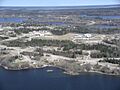
Garden Hill looking north
-
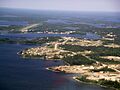
View of Island Lake/Garden Hill
-
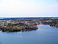
St. Theresa Point


See also
 In Spanish: Lago Island (Manitoba) para niños
