Island Macaskin facts for kids
| Gaelic name | Eilean MhicAsgain |
|---|---|
| OS grid reference | NR786994 |
| Coordinates | 56°08′N 5°34′W / 56.14°N 5.56°W |
| Physical geography | |
| Island group | Islay |
| Area | 50 hectares (0.19 sq mi) |
| Area rank | 199= |
| Highest elevation | 65 m |
| Administration | |
| Sovereign state | United Kingdom |
| Country | Scotland |
| Council area | Argyll and Bute |
| Demographics | |
| Population | 0 Owner=Jenkin family |
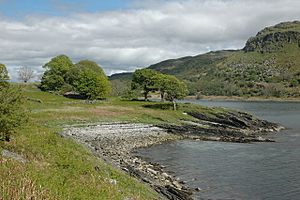
Island Macaskin, also known as MacAskin (Scottish Gaelic: Eilean MhicAsgain), is a small island in Loch Craignish. This sea loch is located in the Inner Hebrides of Scotland. The island is part of Argyll and Bute, a region on Scotland's west coast. It is a quiet, uninhabited place today.
Island Macaskin's Past and Nature
Island Macaskin was once a place where people lived. This is quite special, as many small Scottish islands were not permanently settled. The island is also unusual because it has many mature trees scattered across it. It looks like people stopped living on the island around the 1880s.
Even though no one lives there now, you can still find clear signs that people used to call it home. There are old walls, a pen for sheep, and a lime kiln. A lime kiln was a special oven used to heat limestone. This process created lime, which was important for building and improving farm soil.
Many types of wild flowers grow on Island Macaskin. However, there are not as many different kinds as on a nearby island called Eilean Rìgh.
Island Shape and Rocks
Island Macaskin has a long and narrow shape. It stretches from the southwest to the northeast. This shape runs parallel to the nearby mainland shore. The island is basically a ridge, meaning it's like a long, raised strip of land. The western side is higher than the eastern side. The island's central ridge reaches a height of 65 meters (about 213 feet).
Small rocky islets, called skerries, extend from the south end of the island. These skerries reach into the Sound of Jura, which is a body of water nearby.
The rocks that make up Island Macaskin are mostly metamorphic apidiorite. This is a type of rock that has changed due to heat and pressure. At the south end of the island, you can also find some Dalriadan quartzite. This is another type of hard rock.
Island Macaskin is surrounded by several smaller islands. These include Eilean nan Gabhar, Eilean nan Coinean, Garbh Rèisa, Rèisa an t-Sruith, Rèisa MhicPhàidein, and Eilean na Cille.
 | Lonnie Johnson |
 | Granville Woods |
 | Lewis Howard Latimer |
 | James West |


