Itinerarium facts for kids
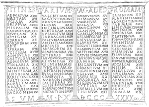
An itinerarium (say: ih-tin-er-AY-ree-um) was a special travel guide from Ancient Rome. It was a list of places like cities, villages, and other stops along a road. It also told you the distances between each stop. Think of it like an early version of a road map or a GPS list of directions! Some famous examples that still exist today are the Antonine Itinerary and the Bordeaux Itinerary.
Contents
How Romans Traveled with Itineraria
Ancient Romans and other travelers usually did not use maps like we do. While some fancy maps existed, they were hard to copy and not common. When traveling on the amazing Roman road system, people needed to know where they were going, how to get there, and how long it would take. The itinerarium helped them with all these things.
At first, an itinerarium was just a simple list of cities along a road. This information came from milestones, which were stone markers placed along major Roman roads to show distances. Soon, these simple lists grew into bigger, master lists. To make these lists easier to understand, Romans sometimes drew diagrams with parallel lines showing different road branches. Parts of these diagrams could be copied and sold. The best ones even had symbols for cities, rest stops, and rivers. These diagrams weren't like modern maps showing land shapes, but they were very useful guides for travelers.
The Roman government sometimes decided to create a huge master itinerarium for all Roman roads. Julius Caesar and Mark Antony started the first known project like this in 44 BC. They hired three Greek geographers named Zenodoxus, Theodotus, and Polyclitus. Their job was to survey all the roads and put together a complete master list. This big task took more than 25 years to finish! The final result was a master itinerarium carved into stone. It was placed near the Pantheon in Rome, so travelers and people who sold itineraries could make copies from it.
Amazing Discoveries: The Vicarello Cups
Archaeologists have found itinerarium information in some surprising places. One cool example is the Vicarello Cups. These are four silver cups from the 1st century AD. Workers found them in 1852 while digging near Vicarello, about 37 kilometers (23 miles) northwest of Rome.
These cups have engravings of the names and distances of 104 stations along the road between Gades (which is modern-day Cadiz in Spain) and Rome. The total distance covered was 1,840 Roman miles, which is about 2,723 kilometers (1,692 miles). People believe these cups were a special gift offered by merchants who traveled from Gades to Rome. The writing on them is a very important source of information about the Roman road network at that time. Scholars call this artifact the Itinerarium Gaditanum. Another famous example is the Itinerarium Burdigalense (Bordeaux Itinerary), which describes the route a pilgrim took from Bordeaux in France to the Holy Land in the year AD 333.
Other Meanings of Itinerarium
The meaning of the word itinerarium changed over many centuries. For example, the Itinerarium Alexandri is a list of the places that Alexander the Great conquered. In the Middle Ages, the term was used for guidebooks written by travelers. Most of these were accounts of pilgrimages to the Holy Land.
See also
- Tabula Peutingeriana
- Periplus
 In Spanish: Itinerario para niños
 | Valerie Thomas |
 | Frederick McKinley Jones |
 | George Edward Alcorn Jr. |
 | Thomas Mensah |


