
Iztapa facts for kids
Quick facts for kids
Iztapa
Ystapa
|
|
|---|---|

Iztapa
Location in Guatemala
|
|
| Country | |
| Department | |
| Population | |
| • Total | 15,000 |
| Climate | Aw |
Iztapa, also known as Puerto de Iztapa, is a town in the Escuintla region of Guatemala. It sits right on the Pacific Ocean coast. The town is surrounded by the Michatoya and Maria Linda Rivers, and also by the Canal de Chiquimulilla. About 15,000 people live in Iztapa.
Contents
Discovering Iztapa
What's in a Name?
Long ago, around 1850, the British called this place Yetapa.
Ancient Tools Found in Iztapa
Archaeologists have found special tools in Iztapa called Fishtail points. These tools were made between 7700 and 7300 BCE. They are a common type of tool found in Mesoamerica, which is a historical region in North and Central America. These findings tell us about an ancient culture that lived in Iztapa a very long time ago.
Building a Port in 1897
In 1897, the president of Guatemala, José María Reina Barrios, had a big idea. He wanted to build a special railroad that would connect the Atlantic and Pacific Oceans. He hoped this railroad would bring a lot of money and new business to Guatemala.
Part of his plan was to build a new port in Iztapa. This port was meant to be better than the existing one at Puerto San José. The president wanted to show off his plans to people from other countries at a big event called the Central America Expo.
However, things didn't go as planned. The price of coffee and silver around the world suddenly dropped. This meant Guatemala didn't have enough money to finish the railroad. The big expo, which was supposed to bring wealth, actually marked the end of the president's time in power.
Where is Iztapa Located?
Iztapa is a coastal town in Guatemala. It is surrounded by other towns and natural features.
 |
Guanagazapa, Escuintla municipality | |
||
| Masagua and Puerto San José, Escuintla municipalities | Taxisco, Santa Rosa municipality | |||
| Pacific Ocean |
Iztapa's Climate
Iztapa has a tropical savanna climate. This means it's usually warm all year round, with a wet season and a dry season.
| Climate data for Iztapa | |||||||||||||
|---|---|---|---|---|---|---|---|---|---|---|---|---|---|
| Month | Jan | Feb | Mar | Apr | May | Jun | Jul | Aug | Sep | Oct | Nov | Dec | Year |
| Mean daily maximum °C (°F) | 32.1 (89.8) |
32.5 (90.5) |
33.1 (91.6) |
33.2 (91.8) |
32.7 (90.9) |
31.9 (89.4) |
32.1 (89.8) |
32.1 (89.8) |
31.4 (88.5) |
31.4 (88.5) |
32.0 (89.6) |
32.1 (89.8) |
32.2 (90.0) |
| Daily mean °C (°F) | 26.2 (79.2) |
26.6 (79.9) |
27.5 (81.5) |
28.2 (82.8) |
28.3 (82.9) |
27.9 (82.2) |
27.8 (82.0) |
27.6 (81.7) |
27.2 (81.0) |
26.8 (80.2) |
27.1 (80.8) |
26.6 (79.9) |
27.3 (81.2) |
| Mean daily minimum °C (°F) | 20.3 (68.5) |
20.7 (69.3) |
22.0 (71.6) |
23.3 (73.9) |
24.0 (75.2) |
23.9 (75.0) |
23.5 (74.3) |
23.1 (73.6) |
23.1 (73.6) |
22.3 (72.1) |
22.2 (72.0) |
21.1 (70.0) |
22.5 (72.4) |
| Average rainfall mm (inches) | 0 (0) |
0 (0) |
6 (0.2) |
38 (1.5) |
136 (5.4) |
288 (11.3) |
241 (9.5) |
213 (8.4) |
320 (12.6) |
244 (9.6) |
31 (1.2) |
3 (0.1) |
1,520 (59.8) |
| Source: Climate-Data.org | |||||||||||||
Sports and Fishing
Iztapa is home to the Deportivo Iztapa football (soccer) club. They play in the National League of Guatemalan football. Their home stadium is called the Estadio Municipal Morón.
Iztapa is also famous for fishing! It's considered one of the best places in the world to catch Sailfish. These are large, fast fish known for their tall, sail-like dorsal fins.
Images for kids
-
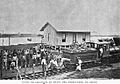
Beginning of the Obero railroad.
-
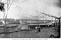
Steamworks in Iztapa.
-
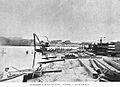
Michatoya river work
-
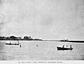
Michatoya river.


See also
 In Spanish: Iztapa para niños
