Jaggan, Queensland facts for kids
Quick facts for kids JagganQueensland |
|||||||||||||||
|---|---|---|---|---|---|---|---|---|---|---|---|---|---|---|---|

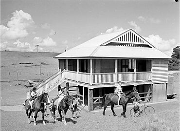
Jaggan State School, 1947
|
|||||||||||||||
| Population | 217 (2021 census) | ||||||||||||||
| • Density | 6.739/km2 (17.45/sq mi) | ||||||||||||||
| Postcode(s) | 4885 | ||||||||||||||
| Area | 32.2 km2 (12.4 sq mi) | ||||||||||||||
| Time zone | AEST (UTC+10:00) | ||||||||||||||
| Location | |||||||||||||||
| LGA(s) | Tablelands Region | ||||||||||||||
| State electorate(s) | Hill | ||||||||||||||
| Federal Division(s) | Kennedy | ||||||||||||||
|
|||||||||||||||
Jaggan is a small town and area in Queensland, Australia. It is located in the Tablelands Region. In 2021, about 217 people lived in Jaggan.
Where is Jaggan?
The town of Jaggan is found in the north-western part of its local area. A main road, the Millaa Millaa–Malanda Road, goes through the area. It comes from Malanda in the north and continues south towards Tarzali. This road also forms part of Jaggan's north-western border.
Most of the land around Jaggan is used for grazing animals on natural grasslands. Some crops are also grown in the north-east part of the area.
Jaggan's History
The area where Jaggan is located was first known as Bunjara Burra. The name Jaggan comes from the Jaggan railway station. The Queensland Railways Department named it on August 31, 1915. Jaggan is an Aboriginal word. It means thick scrub with lawyer vines.
The town was officially mapped out in October 1916.
Jaggan State School
In June 1917, land was set aside for a school. Jaggan State School opened its doors on April 2, 1918. By May 1922, the school had 31 students, but only enough space for 25. The Queensland Government decided to build a new school building in August 1924. The old school building was taken down in 1925. Jaggan State School closed in 1965.
People of Jaggan
In 2016, the area of Jaggan had 188 people living there. By 2021, the population of Jaggan had grown to 217 people.
Education in Jaggan
There are no schools directly in Jaggan. Students usually go to schools in nearby Malanda. The closest government primary school is Malanda State School. For high school, students attend Malanda State High School. Both of these schools are located north of Jaggan in Malanda.
 | Bayard Rustin |
 | Jeannette Carter |
 | Jeremiah A. Brown |


