Jaguas, Gurabo, Puerto Rico facts for kids
Quick facts for kids
Jaguas
|
|
|---|---|
|
Barrio
|
|
 |
|

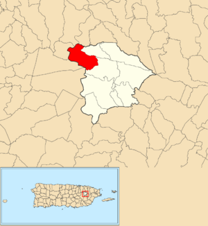
Location of Jaguas within the municipality of Gurabo shown in red
|
|
| Lua error in Module:Location_map at line 416: Malformed coordinates value. | |
| Commonwealth | |
| Municipality | |
| Area | |
| • Total | 3.08 sq mi (8.0 km2) |
| • Land | 2.88 sq mi (7.5 km2) |
| • Water | 0.2 sq mi (0.5 km2) |
| Elevation | 689 ft (210 m) |
| Population
(2010)
|
|
| • Total | 2,083 |
| • Density | 723.3/sq mi (279.3/km2) |
| Source: 2010 Census | |
| Time zone | UTC−4 (AST) |
| ZIP Code |
00778
|
Jaguas is a special area, or barrio, located in the town of Gurabo, Puerto Rico. In 2010, about 2,083 people lived there. It's a part of Puerto Rico, which is a commonwealth of the United States.
Contents
A Look Back: History of Jaguas
How Puerto Rico Became Part of the U.S.
Long ago, after the Spanish–American War ended, Spain gave Puerto Rico to the United States. This happened because of a special agreement called the Treaty of Paris of 1898. Puerto Rico then became an unincorporated territory of the United States. This means it is governed by the U.S. but is not a state.
Early Population Count
In 1899, the United States Department of War took a count of all the people in Puerto Rico. This count is called a census. The census found that 868 people lived in the Jaguas barrio at that time.
| Historical population | |||
|---|---|---|---|
| Census | Pop. | %± | |
| 1900 | 868 | — | |
| 1980 | 1,551 | — | |
| 1990 | 1,790 | 15.4% | |
| 2000 | 2,075 | 15.9% | |
| 2010 | 2,083 | 0.4% | |
| U.S. Decennial Census 1899 (shown as 1900) 1910-1930 1930-1950 1980-2000 2010 |
|||
Understanding Barrios and Sectors
What is a Barrio?
In Puerto Rico, a barrio is like a neighborhood or a district. It's a way to divide up a town or municipality into smaller parts. Jaguas is one of these barrios in Gurabo.
What are Sectors?
Barrios are often divided even further into smaller areas called sectores. Sectores means sectors in English. These smaller areas can have different names, like urbanización (a housing development) or reparto (a subdivision).
The following sectors are found within the Jaguas barrio:
Hacienda Mirador, Jaguas Lomas, Quintas del Lago, Sector Adorno, Sector Arturo López, Sector Cáceres, Sector Calletano Sanchéz, Sector Carazo, Sector Carrasquillo, Sector Colón Flores, Sector Cosme, Sector Negrón, Sector Díaz, Sector Felipe Ocasio, Sector Felix Díaz, Sector Guillermo Flores, Sector Isidro Vázquez, Sector Jaguas Llanos, Sector Jaguas Peñón, Sector Juan Guadalupe, Sector La Agrícola, Sector Las Casitas, Sector Llinás, Sector Los Colones, Sector Los Oyola, Sector Los Paganes, Sector Los Quiñones, Sector Los Vives, Sector Márquez, Sector Núñez, Sector Ocasio, Sector Oller, Sector Olmedo, Sector Oyola, Sector Pagán, Sector Pepe Díaz, Sector Richard Rivera, Sector Soto, Sector Tino Torres, Sector Urrutia, Sector Viera Pérez, Sector Vives, and Sector Zavala.
See also
 In Spanish: Jaguas (Gurabo) para niños
- List of communities in Puerto Rico
- List of barrios and sectors of Gurabo, Puerto Rico
 | Georgia Louise Harris Brown |
 | Julian Abele |
 | Norma Merrick Sklarek |
 | William Sidney Pittman |

