Jamboree Heights, Queensland facts for kids
Quick facts for kids Jamboree HeightsBrisbane, Queensland |
|||||||||||||||
|---|---|---|---|---|---|---|---|---|---|---|---|---|---|---|---|

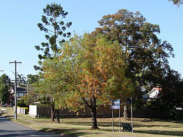
Jamboree Park in Guide Street, 2009
|
|||||||||||||||
| Population | 3,141 (2021 census) | ||||||||||||||
| • Density | 2,620/km2 (6,800/sq mi) | ||||||||||||||
| Postcode(s) | 4074 | ||||||||||||||
| Area | 1.2 km2 (0.5 sq mi) | ||||||||||||||
| Time zone | AEST (UTC+10:00) | ||||||||||||||
| Location | 16.1 km (10 mi) SW of Brisbane CBD | ||||||||||||||
| LGA(s) | City of Brisbane (Jamboree Ward) |
||||||||||||||
| State electorate(s) | Mount Ommaney | ||||||||||||||
| Federal Division(s) | Oxley | ||||||||||||||
|
|||||||||||||||
Jamboree Heights is a suburb located in the south-west of Brisbane, Queensland, Australia. It's a part of the big City of Brisbane. In 2021, about 3,141 people lived here.
Contents
Exploring Jamboree Heights' Location
Jamboree Heights is about 16.2 kilometers (10 miles) by road south-west of the main part of Brisbane City.
The suburb has clear borders. To the east, it's next to the Centenary Motorway. Sumners Road forms its southern edge. On the west, you'll find Estate Road and Beanland Street. To the north-west, it's bordered by Lofts Road and Dandenong Road. Finally, the Mount Ommaney Shopping Centre is just north of Jamboree Heights.
Most of the land in Jamboree Heights is used for homes. There is also a small shopping center on Guide Street where people can buy things.
A Look Back at Jamboree Heights' History
The area that is now Jamboree Heights was once part of a large property called Wolston Estate. This land belonged to M. B. Goggs. His family had owned the land since the 1860s. Goggs Road is named after them.
In 1879, a local government area called Yeerongpilly Division was created. Later, in 1891, some parts of this division were separated to form Sherwood Division.
The western part of the original Wolston Estate became what we now call the Centenary Suburbs. This area had 54 farms, covering about 3,000 acres. These farms were offered for sale in 1901, but only three were sold at first.
In 1903, the Sherwood Division became the Shire of Sherwood. The Wolston Estate was part of this Shire. Then, in 1925, the Shire of Sherwood joined with the City of Brisbane.
Jamboree Heights was developed as part of a big project by a company called Hooker. This project, known as the 'Centenary Project', started in 1959. The suburb was officially named Jamboree Heights on July 1, 1969. Its name remembers the 8th Australian Scout Jamboree, which took place nearby in late 1967 and early 1968.
Jamboree Heights State School opened its doors to students on January 29, 1974.
Who Lives in Jamboree Heights?
In 2011, Jamboree Heights had a population of 3,057 people. About 49.4% were female and 50.6% were male. The average age was 36 years, which was a bit younger than the Australian average.
Most people (95.3%) living in Jamboree Heights were born in Australia. Other countries of birth included New Zealand, England, Vietnam, South Africa, and China. Most people (92%) spoke only English at home. Other languages spoken included Vietnamese, Cantonese, Mandarin, and Arabic.
By 2016, the population had grown slightly to 3,093 people. In the latest count in 2021, Jamboree Heights had 3,141 residents.
Learning in Jamboree Heights
Jamboree Heights State School is a primary school for children from Early Childhood (Kindergarten) to Year 6. It's located at 35 Beanland Street. In 2017, the school had 819 students and 61 teachers. It also has a special program for students who need extra support.
There isn't a high school directly in Jamboree Heights. The closest secondary school for older students is Centenary State High School, which is in Jindalee.
Important Services in Jamboree Heights
Jamboree Heights has several important services to help the community:
- A Police Beat is located at 31 Lanena Street. You can call them if you need help.
- A Fire Station is at 238 Arrabri Avenue. They are ready to respond to emergencies.
- An Ambulance Station is on Westcombe Street. They provide medical help when needed.
- There is also an Australian Naval Cadet training ship, called TS Vengeance, on Moolanda Street. This is a youth program that teaches skills like leadership and teamwork.
Getting Around Jamboree Heights
Many bus services connect Jamboree Heights to other areas. These buses often go to and from the Mount Ommaney Shopping Centre Bus Exchange. From there, you can travel to the city and other places.
Some of the bus routes include:
- 454: Travels from Riverhills, through Mount Ommaney Bus Exchange, to Indooroopilly, Toowong, and the City.
- 460: Connects Heathwood, Forest Lake, Mount Ommaney, Indooroopilly, and the City.
- 453: Goes from Mount Ommaney, through Jindalee, to Indooroopilly, and the City.
- 106: Travels from Mount Ommaney, through Sinnamon Park, Oxley, Corinda, Sherwood, Graceville, Chelmer, and ends in Indooroopilly.
There is also a special bus run, the S703. While it's open to everyone, it's mainly used by school students going to Kenmore State High School.
 | Chris Smalls |
 | Fred Hampton |
 | Ralph Abernathy |


