Sumner, Queensland facts for kids
Quick facts for kids SumnerBrisbane, Queensland |
|||||||||||||||
|---|---|---|---|---|---|---|---|---|---|---|---|---|---|---|---|

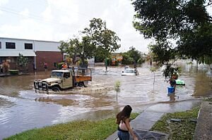
Spine Street during the 2011 floods
|
|||||||||||||||
| Population | 603 (2021 census) | ||||||||||||||
| • Density | 317/km2 (820/sq mi) | ||||||||||||||
| Postcode(s) | 4074 | ||||||||||||||
| Area | 1.9 km2 (0.7 sq mi) | ||||||||||||||
| Time zone | AEST (UTC+10:00) | ||||||||||||||
| Location | 18.5 km (11 mi) SW of Brisbane CBD | ||||||||||||||
| LGA(s) | City of Brisbane | ||||||||||||||
| State electorate(s) |
|
||||||||||||||
| Federal Division(s) | Ryan | ||||||||||||||
|
|||||||||||||||
Sumner is a suburb located in the south-western part of Brisbane, Queensland, Australia. It's a place where people live and work. In 2021, about 603 people called Sumner home.
Contents
Where is Sumner?
Sumner is located about 15 kilometers (9.3 miles) south-west of the main city area of Brisbane.
The suburb has two main parts:
- The western side is mostly for homes where people live.
- The eastern side is a large industrial area called Sumner Park, where businesses and factories are located.
A Look at Sumner's History
The land that makes up Sumner today was once part of a much larger area called the Wolston Estate. This estate had many farms and was first offered for sale way back in 1901.
Over time, the way the area was governed changed.
- In 1879, a local government area called Yeerongpilly Division was created.
- Later, in 1891, parts of this area became the Sherwood Division, which then became the Shire of Sherwood in 1903.
- Finally, in 1925, the Shire of Sherwood joined with other areas to form the larger City of Brisbane we know today.
Sumner was developed as part of a big building project in 1959 by a company called Hooker. Sumner and nearby suburbs like Jindalee are known as the Centenary Suburbs. The Queensland Government officially named Sumner in 1969. The name "Sumner" came from Sumner Road, which forms the northern border of the suburb. It's believed that a lawyer named Sumner owned property at the end of this road and visited it on weekends.
In 2001, the Centenary Memorial Gardens, a special place for remembrance, was opened in the area.
Like many areas in Brisbane, parts of Sumner experienced flooding during the big 2011 Brisbane floods event.
Who Lives in Sumner?
Let's look at the people who live in Sumner:
- In 2011, there were 539 people living here. The average age was 29 years old, which is younger than the average age for all of Australia.
- Most people (61.6%) in Sumner were born in Australia. Other people came from countries like New Zealand, England, Sri Lanka, and India.
- Most people (75.4%) spoke only English at home, but other languages like Vietnamese, Sinhalese, and Punjabi were also spoken.
- By 2016, the population grew slightly to 595 people.
- In the most recent count in 2021, Sumner had a population of 603 people.
Schools Near Sumner
Sumner itself doesn't have any schools.
- For younger students, the closest primary school is Middle Park State School, which is in the nearby suburb of Middle Park.
- For older students, the nearest high school is Centenary State High School in Jindalee.
Important Places and Facilities
- Centenary Memorial Gardens is a large crematorium and cemetery. It covers about 40 acres and is located at 353 Wacol Station Road. 27°34′00″S 152°55′30″E / 27.5666°S 152.9249°E
Parks and Green Spaces
Sumner has several parks where people can relax and enjoy the outdoors:
- Spine Street Park 27°34′08″S 152°56′27″E / 27.5689°S 152.9408°E
- Wacol Station Road Park 27°33′51″S 152°55′23″E / 27.5642°S 152.9230°E
- Wolston Road Park 27°34′04″S 152°55′54″E / 27.5678°S 152.9316°E
 | Janet Taylor Pickett |
 | Synthia Saint James |
 | Howardena Pindell |
 | Faith Ringgold |


