
Wacol, Queensland facts for kids
Quick facts for kids WacolBrisbane, Queensland |
|||||||||||||||
|---|---|---|---|---|---|---|---|---|---|---|---|---|---|---|---|
_-_panoramio.jpg)
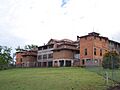
The Park Centre for Mental Health, 2010
|
|||||||||||||||

Wacol
Location in Queensland
|
|||||||||||||||
| Population | 4,253 (2021 census) | ||||||||||||||
| • Density | 233.7/km2 (605/sq mi) | ||||||||||||||
| Postcode(s) | 4076 | ||||||||||||||
| Area | 18.2 km2 (7.0 sq mi) | ||||||||||||||
| Time zone | AEST (UTC+10:00) | ||||||||||||||
| Location | 21.3 km (13 mi) SW of Brisbane CBD | ||||||||||||||
| LGA(s) | City of Brisbane (Jamboree Ward) |
||||||||||||||
| State electorate(s) | Inala | ||||||||||||||
| Federal Division(s) | Oxley | ||||||||||||||
|
|||||||||||||||
Wacol is a suburb located in the City of Brisbane, Queensland, Australia. It is home to many important facilities and has a rich history. In the 2021 census, Wacol had a population of 4,253 people.
Contents
Exploring Wacol's Location
Wacol is about 18 kilometers (11 miles) southwest of the Brisbane central business district. The Brisbane River forms its western border. Wolston Creek is generally to the north.
Wacol's Natural Features
Wacol has a small island in the Brisbane River called Cockatoo Island. There is also a small hill in the south of the suburb called Termination Hill. It is about 40 meters (130 feet) high.
Trains and Transport in Wacol
The main Brisbane-Ipswich railway line runs through Wacol. You can find two train stations here: Wacol railway station and Gailes railway station. Even though it's called Gailes, this station is actually in Wacol!
A Look Back: Wacol's History
Wacol has a long and interesting past, from early explorations to its role in World War II.
How Wacol Got Its Name
Termination Hill was named by explorer John Oxley in December 1823. This was the furthest point he explored up the Brisbane River on his first trip. The suburb's name, Wacol, comes from its railway station. The station was first called Wolston in 1874, after Wolston House. But because it sounded too much like Wilston, it was renamed Wacol in 1927. The name Wacol was made up from the words weigh coal, as the station was mainly used for handling coal.
Wolston House: A Historic Home
Wolston House opened in 1852 and is a very old building. It is the only early settlement building along the Brisbane River that is still standing today. The National Trust of Queensland helped save it from being torn down.
.jpg)
Wacol During World War II
During World War II, the American military built Camp Columbia in Wacol in 1942. After the war, the Australian Government used it as a place for new migrants arriving in Australia from 1949 to 1987. A special school for these new Australians was also opened in Wacol East.
Growth of Facilities in Wacol
After the war, Wacol became home to several important facilities. These included places for young people and those needing special care. Over time, more such facilities were built in the area.
In 2011, the Royal Society for the Prevention of Cruelty to Animals moved its Brisbane animal hospital and adoption center to Wacol.
Who Lives in Wacol?
In the 2021 census, Wacol had 4,253 residents. Let's look at some details from the 2016 census survey.
Wacol's Population Snapshot
In 2016, Wacol had 3,761 people. There were more males (81.1%) than females (18.9%). The average age was 33 years, which is younger than the Australian average. A large number of people (68.6%) were between 20 and 44 years old.
Where Wacol Residents Come From
Most people living in Wacol (79.4%) were born in Australia. Other common birthplaces included New Zealand, Vietnam, and England. Most people (15.8%) spoke only English at home. Other languages spoken included Vietnamese and Tagalog.
Places of Historical Importance
Wacol has several sites that are recognized for their historical value. These are called heritage-listed sites.
- Wolston Park Hospital (now The Park Centre for Mental Health) at 60 Grindle Road.
- Wolston House at 223 Grindle Road.
Important Facilities in Wacol
Wacol is home to several large facilities that serve the community.

Care and Support Centres
- The Park Centre for Mental Health: This center has provided care for people with mental health needs since 1865.
- Royal Society for the Prevention of Cruelty to Animals: This is where the Brisbane animal hospital and adoption shelter are located.
Other Key Facilities
- Wacol Wastewater Treatment Plant: This plant helps treat sewage for the area.
- Industrial Park: A large area in Wacol is used for various industries and businesses.
Learning and Education in Wacol
Wacol has schools that cater to different educational needs.
- Carole Park State School: This is a government primary school for students from Prep to Year 6. It also has a special education program.
- Brisbane Youth Education and Training Centre: This school is located within the Brisbane Youth Detention Centre. It provides education for students from Years 6 to 12.
There isn't a regular high school in Wacol itself. Students usually attend high schools in nearby suburbs like Durack, Forest Lake, or Springfield.
Fun and Recreation in Wacol
Wacol offers places for sports and outdoor activities.
Golf Courses
- Gailes Golf Club: An 18-hole golf course open to members and visitors.
- Wolston Park Golf Club: Another 18-hole golf course for golf lovers.
Local Parks
Wacol has several parks where people can relax and enjoy nature:
- M. Z. Holland Memorial Park
- Newton Place Park
- PJ McIlwain Place: This park is the home ground for the Centenary Junior Rugby League.
- Pooh Corner
- Progress Road Park
- Wacol Bushlands
Getting Around Wacol
Wacol is well-connected by major roads and public transport.
Roads and Highways
The Ipswich Motorway runs through Wacol. A big upgrade to this road was finished in 2010. The Logan Motorway also connects to the Ipswich Motorway in the southern part of the suburb.
Train Travel
You can catch regular train services from Wacol railway station and Gailes railway station. These trains connect Wacol to Brisbane, Ipswich, and Rosewood. In 2011, about 11.2% of people used public transport to get to work, while most (66.3%) drove their cars.
Images for kids
-
The Park Centre for Mental Health, 2010
-
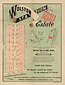
Real estate map of Wolston Station Estate, circa 1900
-
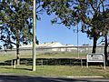
Brisbane Correctional Centre, 2017
