
Moggill, Queensland facts for kids
Quick facts for kids MoggillBrisbane, Queensland |
|||||||||||||||
|---|---|---|---|---|---|---|---|---|---|---|---|---|---|---|---|

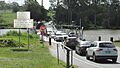
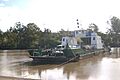
Cars disembarking to Moggill from the Moggill ferry while other cars wait to board, 2021
|
|||||||||||||||

Moggill
Location in Queensland
|
|||||||||||||||
| Population | 5,029 (2021 census) | ||||||||||||||
| • Density | 429.8/km2 (1,113/sq mi) | ||||||||||||||
| Postcode(s) | 4070 | ||||||||||||||
| Area | 11.7 km2 (4.5 sq mi) | ||||||||||||||
| Time zone | AEST (UTC+10:00) | ||||||||||||||
| Location | 22.3 km (14 mi) SW of Brisbane CBD | ||||||||||||||
| LGA(s) | City of Brisbane (Pullenvale Ward) |
||||||||||||||
| State electorate(s) | Moggill | ||||||||||||||
| Federal Division(s) | Ryan | ||||||||||||||
|
|||||||||||||||
Moggill is a suburb located in the City of Brisbane, Queensland, Australia. It's a place where many people live and work. In 2021, about 5,029 people called Moggill home.
Contents
Exploring Moggill's Location
Moggill is about 22.3 kilometres (13.9 miles) southwest of the Brisbane CBD (Central Business District).
River Boundaries
The Brisbane River forms the eastern, southern, and western edges of Moggill. Two parts of the river here are called:
- Cockatoo Reach
- Redbank Reach
Priors Pocket Neighbourhood
In the southeast of Moggill, there's a neighbourhood called Priors Pocket. It's also known as Toocoobah. This area was officially named on August 16, 1975. It got its name from Thomas Lodge Murray-Prior, who owned land there a long time ago. Priors Pocket has a mix of smaller and larger homes, plus a few farms.
Moggill's Rich History
Moggill has a long and interesting history, going back thousands of years.
First Peoples of the Land
The Garumngar people are the traditional owners of the land around the Upper Brisbane River. Their language region includes areas like Ipswich, Brisbane, Somerset, and Moreton Bay. This shows that Indigenous Australians lived here for a very long time.
Evidence of Aboriginal life includes bora grounds (special ceremonial places) near the Moggill Pony Club and O'Brien Road. Another bora ring is found at the end of Riversleigh Road. The Brisbane River and Moggill Creek provided many resources for these communities.
European Arrival and Early Days
In 1823, John Oxley was the first European visitor to the area. He named the Priors Pocket area Termination Plains.
In 1846, the first paddle steamer boat service started from Brisbane to Ipswich. These boats traveled along the Brisbane and Bremer rivers, passing Moggill. The trip took about four to seven hours. Before this, rowboats operated by convicts took around 12 hours!
In 1848, a successful coal mine opened in Moggill, owned by John Williams.
Growing as a Township
The first survey of Moggill happened in 1851. A town was planned near Weekes Road, but it was later built closer to where the school is today.
The Moggill Cemetery was created in 1865.
The Moggill State School opened its doors on February 12, 1866. It started with 53 students. The school was a two-room building until 1970, when more families moved to the area. In 2016, the school celebrated its 150th birthday!
In 1868, the Moggill Methodist Church was built. It's still part of the Moggill Uniting Church today.

In 1877, a newspaper described the farmers in Moggill as "well-to-do." This means they were doing well financially. The land was known for its rich soil, which made it great for growing crops.
The Moggill Ferry
The Moggill punt (or ferry) was very important for crossing the Brisbane River. In 1884, the ferry sank and was replaced by a hand-pulled, rope-guided ferry.
Quarry Operations
In 1886, a company called Colledge Brothers started operating the Moggill Blue Metal Quarry. They employed 20 men. Later, in 1924, the Moggill Quarry was bought by another company.
Modern Moggill
In 1968, the original Moggill State School building was moved. It became the Anglican Church.
In 1973, Moggill was divided into three suburbs: Moggill, Anstead, and Bellbowrie. The name "Moggill" comes from the Yuggera (Jagera) Nation language, meaning "water dragon."
After 2004, many pineapple farms in Moggill began to be sold and turned into housing estates. Many local people wanted to keep the area's rural feel with larger properties. However, new homes were built on smaller blocks of land.

Who Lives in Moggill?
In 2021, Moggill had a population of 5,029 people. Let's look at some details from earlier years:
In 2011, Moggill had 3,606 people.
- About 51.1% were female and 48.9% were male.
- The average age was 34 years old.
- Children under 15 made up 27.2% of the population.
- Most people (67.1%) were born in Australia. Other common birthplaces included England (7.3%), South Africa (5.8%), and New Zealand (3.6%).
- English was spoken at home by 86.3% of people.
- The most common religious choice was "No Religion" (25.9%), followed by Catholic (24.1%) and Anglican (18.5%).
Important Places in Moggill
Moggill has several sites that are important for their history:
- St Michael's Anglican Church (which used to be the Moggill State School)
- The former Moggill Methodist Church
- Riverside Colliery Residence
- Fig Tree Lodge
Learning and Education
Moggill has a primary school for younger students.
Moggill State School
Moggill State School is a government primary school for students from Prep to Year 6. It's located at 3417 Moggill Road. In 2018, the school had 750 students. It also has a special education program.
Secondary Education
There isn't a high school directly in Moggill. The closest government high school is Kenmore State High School in Kenmore. This school serves students from Year 7 to Year 12, and students from Moggill attend there.
Emergency Services
Moggill is well-covered by emergency services to keep everyone safe.
Police Services
Moggill is part of the Queensland Police Service's Brisbane West District. The Bellbowrie Neighbourhood Police Beat helps keep the area safe. The closest police station is Indooroopilly Police Station.
Medical Help
The Queensland Ambulance Service provides emergency medical care and transport for Moggill residents. A new ambulance station is planned for nearby Pinjarra Hills, which will help serve Moggill even better.
Fire and Rescue
The Queensland Fire and Rescue Service covers Moggill. A new fire station in Pullenvale, which opened in 2010, is the closest station serving Moggill residents.
Community Support During Emergencies

During the big Brisbane River flood in 2011, the Uniting Church in Moggill was used as a place where people could go for safety and help.
Getting Around Moggill
There are several ways to travel in and out of Moggill.
Water Transport


The Moggill Ferry is a special cable ferry that crosses the Brisbane River. It connects Moggill Road in Moggill to Moggill Ferry Road in Riverview. The ferry has been motorized since the 1940s. It's free for people walking or riding bicycles.
During the 2011 Brisbane River flood, the ferry service had to stop. The strong floodwaters even broke one of its cables!
Road Connections
Moggill Road (State Route 33) runs through Moggill. It connects the suburb to Brisbane via Toowong, Indooroopilly, and Bellbowrie.
There's also a plan for a future road corridor that could include a bridge to replace the Moggill Ferry. This corridor would connect the Centenary Highway to the Warrego Highway.
Bus Services
Transport for Brisbane operates two bus routes, P443 and 444, which are part of the Translink public transport system. Both routes connect Moggill to King George Square busway station in Brisbane. Route 444 continues to the Cultural Centre busway station in South Brisbane.
Taxi Services
Council Cab and Karana Downs Personalised Public Transport (PPT) services are available. The Council Cab helps residents who find it hard to get to local shops. The Karana Downs PPT uses larger taxis and has a fixed route along Kangaroo Gully and Moggill Roads. Regular taxi services are also available.
Libraries and Community
Moggill residents have access to library services and community groups.
Public Libraries
The Brisbane City Council offers a mobile library service every Thursday at Bellbowrie Shopping Plaza. The closest full library branch is the Kenmore Library.
Community Groups
The Moggill Historical Society was started in 2013. It works to research and protect the history of the Moggill area.
There's also a Moggill branch of the Country Women's Association. They meet once a month at the Bellbowrie Community Church.
Sports and Recreation
While no sports clubs are directly in Moggill, several clubs use the Moggill name and are located nearby.
Local Sports Clubs
The Moggill Football Club and Moggill Cricket Club are located at the Bellbowrie Sports and Recreation Club.
Future Sports Park
The Brisbane City Council has plans for a future Moggill District Sports Park. This park would be located along Moggill Road and would have facilities for many sports, including:
- Rugby League/Union fields
- Netball courts
- Tennis courts
- Cricket ovals
- Australian Football oval
A cricket oval was built in 2010 as part of a new housing area called The Pitch.
Parks and Green Spaces
Moggill has many parks for people to enjoy.
Main Parks
- Moggill Ferry Reserve, next to the Moggill Ferry, has a playground and barbecue area.
- Westaway Park in Witty Street has playground equipment, barbecue facilities, and toilets.
Other Parks
Many other parks are located throughout Moggill, often next to the Brisbane River. These include:
- Aitcheson Street (East and West)
- Sheldrake Place & Weekes Road
- Ellerby Road
- Livesay Road, Beaufort Crescent and Forestwood
- Moggill Road (no.3777)
- Myora Street
- Priors Pocket Road (no.301)
- Priors Pocket Road Park (No.545)
- Stratford Street
Most of the land between the Brisbane River and private properties is designated as Park Land by the Brisbane City Council.
Images for kids
-
Cars disembarking to Moggill from the Moggill ferry while other cars wait to board, 2021
-
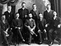
Men of the Anstead family, early settlers in the Moggill area.
-

Estate map for a sale of land in Moggill (1888)
-
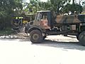
Army vehicle used in the clean-up following the 2011 floods.
-
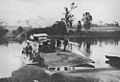
Moggill Ferry, 1928
-
Moggill Ferry, 2008
