Anstead, Queensland facts for kids
Quick facts for kids AnsteadBrisbane, Queensland |
|||||||||||||||
|---|---|---|---|---|---|---|---|---|---|---|---|---|---|---|---|

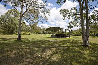
Anstead Bushland Reserve, 2012
|
|||||||||||||||
| Population | 1,522 (2021 census) | ||||||||||||||
| • Density | 106.4/km2 (276/sq mi) | ||||||||||||||
| Established | 1975 | ||||||||||||||
| Postcode(s) | 4070 | ||||||||||||||
| Area | 14.3 km2 (5.5 sq mi) | ||||||||||||||
| Time zone | AEST (UTC+10:00) | ||||||||||||||
| Location | 21.1 km (13 mi) WSW of Brisbane CBD | ||||||||||||||
| LGA(s) | City of Brisbane (Pullenvale Ward) |
||||||||||||||
| State electorate(s) | Moggill | ||||||||||||||
| Federal Division(s) | Ryan | ||||||||||||||
|
|||||||||||||||
Anstead is a suburb located on the western edge of Brisbane, Queensland, Australia. It's known for its natural beauty and peaceful, rural feel. In 2021, about 1,522 people lived here.
Contents
Where is Anstead?
Anstead is about 21 kilometers (13 miles) southwest of Brisbane's city center.
To the west, Anstead is bordered by the Brisbane River. The northern part of Anstead is home to the Moggill Conservation Park, a protected natural area. This area used to be mostly farmland. Now, it has many homes on large blocks of land, giving it a country-like feel. Some parts are still undeveloped or used for grazing animals.
Mount Crosby Road is a main road that runs through Anstead from west to east.
A Look at Anstead's History
Anstead is named after John Anstead. He was an early settler who worked with timber and stone in the 1860s. The area officially became known as Anstead in 1975. Before that, it was part of the nearby suburb of Moggill.
Who Lives in Anstead?
In 2021, the population of Anstead was 1,522 people. This number has grown slightly over the years.
Schools Near Anstead
Anstead does not have its own schools. Students usually go to schools in nearby suburbs.
- The closest primary school is Moggill State School in Moggill.
- The nearest high school is Kenmore State High School in Kenmore.
Future Plans for Roads
There's a long-term plan for a new road in this area. This road, called the Moggill Pocket Arterial Road Transport Corridor, might include a new bridge over the Brisbane River. This bridge could replace the current Moggill Ferry.
Land for this road was set aside back in the 1960s and 1970s. It would connect the Centenary Highway to the Warrego Highway. However, there is no set date or money available yet to start building this road.
 | George Robert Carruthers |
 | Patricia Bath |
 | Jan Ernst Matzeliger |
 | Alexander Miles |


