Bellbowrie, Queensland facts for kids
Quick facts for kids BellbowrieBrisbane, Queensland |
|||||||||||||||
|---|---|---|---|---|---|---|---|---|---|---|---|---|---|---|---|

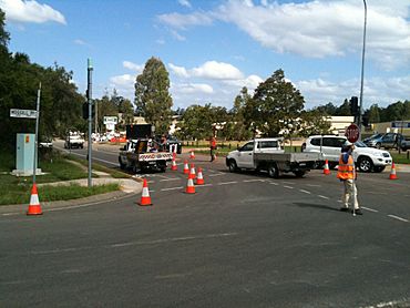
Check Point at the intersection of Moggill and Birkin Roads in Bellbowrie, 2011
|
|||||||||||||||
| Population | 5,495 (2021 census) | ||||||||||||||
| • Density | 964/km2 (2,500/sq mi) | ||||||||||||||
| Postcode(s) | 4070 | ||||||||||||||
| Area | 5.7 km2 (2.2 sq mi) | ||||||||||||||
| Time zone | AEST (UTC+10:00) | ||||||||||||||
| Location | 21.8 km (14 mi) SW of Brisbane CBD | ||||||||||||||
| LGA(s) | City of Brisbane (Pullenvale Ward) |
||||||||||||||
| State electorate(s) | Moggill | ||||||||||||||
| Federal Division(s) | Ryan | ||||||||||||||
|
|||||||||||||||
Bellbowrie is a suburb in the City of Brisbane, Queensland, Australia. In the 2021 census, Bellbowrie had a population of 5,495 people.
Bellbowrie is located on the northern side of the Brisbane River. It is about 17 kilometers (10.5 miles) west-southwest of Brisbane's city center. This area used to be more rural, but it is growing quickly as Brisbane expands.
Contents
Exploring Bellbowrie's Location
Bellbowrie is bordered by Pullen Pullen Creek to the north. The Brisbane River forms its eastern boundary. Two parts of the river, called Pullen Reach and Goggs Reach, flow past the suburb.
Moggill Road cuts through the middle of Bellbowrie. This road is important for traffic traveling between Ipswich and central Brisbane. People can also use the Moggill Ferry to cross the river. This offers another way to get to Moggill Road, avoiding the Centenary Highway.
Bellbowrie is surrounded by other suburbs. These include Moggill, Pullenvale, Pinjarra Hills, and Anstead.
The streets in Bellbowrie look nice because the power lines are hidden underground. This means you won't see many power poles around.
Bellbowrie is part of the Pullenvale Ward for local Brisbane City Council elections. For state elections, it's in the seat of Moggill. For federal elections, it's in the seat of Ryan.
Bellbowrie's Past: A Brief History
The name Bellbowrie comes from an Aboriginal word. It might be from the Hunter River area in New South Wales. The word possibly means flowering gum, perhaps referring to the red gum tree.
The suburb was officially named on 4 November 1972. Its boundaries were set on 11 August 1975.
Early Development and Floods
Building in Bellbowrie started in the early 1970s. However, development slowed down after the 1974 Brisbane flood. Many of the lower areas of the suburb were covered in water.
After the Wivenhoe Dam was built in the 1980s, people felt safer from floods. This led to more building. Many landowners are now dividing their large properties into smaller ones. Because of this, some bushland areas are being cleared.
On 13 December 1990, Bellbowrie's boundaries were made larger. They now included land that was previously part of Anstead.
Around 2001, new housing estates began to be built. These homes were on land that used to be pineapple farms.
The 2011 Floods
In the 2011 Brisbane floods, the Brisbane River rose very high. Some small parts of Bellbowrie were flooded. A bigger problem was that the roads leading into the area were underwater. This cut off Bellbowrie and other suburbs. People lost electricity and phone service. There was also a shortage of food because the local supermarket was flooded.
The Uniting Church became a safe place for people whose homes were flooded. It also acted as a community food bank. Supplies were brought in by helicopter to help those in need.
Who Lives in Bellbowrie?
The number of people living in Bellbowrie has grown over the years.
- In the 2011 census, there were 5,413 people.
- In the 2016 census, the population was 5,462 people.
- In the 2021 census, Bellbowrie had 5,495 people.
Moggill Cemetery: A Place of History
The Moggill Cemetery is located on Moggill Road in Bellbowrie. It is believed that this land was used as a church graveyard around 1855. George Mounser, who drowned in 1855, is thought to be the first person buried there.
In 1865, the land was officially made a cemetery. Over time, control of the cemetery changed hands. In 1930, the Brisbane City Council took over its management.
Learning and Education in Bellbowrie
There are no schools directly in Bellbowrie. Students usually go to schools in nearby suburbs.
- The closest government primary school is Moggill State School in Moggill.
- The nearest government secondary school is Kenmore State High School in Kenmore.
Fun and Facilities in Bellbowrie
Bellbowrie has many places for recreation and activities.
- There are lots of off-leash areas where dogs can play freely.
- Some residents who live near the Brisbane River have boat ramps. This allows them to easily access the river for boating.
Community Services
The Brisbane City Council's mobile library visits Bellbowrie every week. You can find it in the Bellbowrie Shopping Plaza carpark.
The Bellbowrie Community Church is located at 3077 Moggill Road.
Many community groups are active in the area, including:
- Rural Environmental Planning Association Inc.
- Moggill Girl Guides
- Moggill Scout Group
The local Scout group is called "Moggill Scout Group." They meet at 17 Mahonia Street. The name Tyakunda means land of the rolling hills in an Aboriginal language.
The Moggill branch of the Queensland Country Women's Association also meets at the Bellbowrie Community Church.
Sporting Clubs in Bellbowrie
The Bellbowrie Sports & Recreation Club Inc., often called "the sports & rec," is a popular place. It is located on Sugarwood Street and is home to several sporting clubs:
- Bellbowrie "Strikers" Hockey Club Inc.
- Moggill Football Club Inc.
- Moggill Cricket Club
- Moggill "Mustangs" Junior Australian Football Club.
The Bellbowrie Sports & Recreation Club also has a skate park. There are cricket nets and a court for both tennis and basketball.
A Brisbane City Council public swimming pool is also on Sugarwood Street. This pool is home to the Bellbowrie Swimming Club.
 | Dorothy Vaughan |
 | Charles Henry Turner |
 | Hildrus Poindexter |
 | Henry Cecil McBay |


