Kenmore, Queensland facts for kids
Quick facts for kids KenmoreBrisbane, Queensland |
|||||||||||||||
|---|---|---|---|---|---|---|---|---|---|---|---|---|---|---|---|

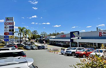
Kenmore Village shopping centre, 2021
|
|||||||||||||||
| Population | 9,675 (2021 census) | ||||||||||||||
| • Density | 1,668/km2 (4,320/sq mi) | ||||||||||||||
| Postcode(s) | 4069 | ||||||||||||||
| Area | 5.8 km2 (2.2 sq mi) | ||||||||||||||
| Time zone | AEST (UTC+10:00) | ||||||||||||||
| Location | 13.6 km (8 mi) SW of Brisbane CBD | ||||||||||||||
| LGA(s) | City of Brisbane (Pullenvale Ward) |
||||||||||||||
| State electorate(s) | Moggill | ||||||||||||||
| Federal Division(s) | Ryan | ||||||||||||||
|
|||||||||||||||
Kenmore is a suburb in the City of Brisbane, Queensland, Australia. It is located right by the Brisbane River. In 2021 census, Kenmore was home to 9,675 people.
Contents
Exploring Kenmore's Location

Kenmore is about 13.6 kilometres (8.5 miles) by road south-west of the centre of Brisbane.
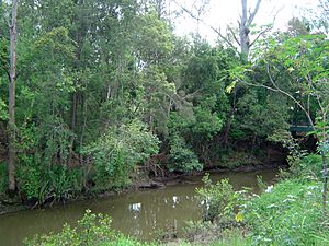
The suburb has natural borders. Cubberla Creek is to the north-east. The Centenary Highway is to the south-east. The Brisbane River forms its southern edge. Moggill Creek is to the west.
There's a small area called Mosquito Island in the Brisbane River. It's about 2.2 hectares (5.4 acres) in size. Today, it's no longer separated from the mainland by water.
A Look Back at Kenmore's History
European settlers first arrived in the 1840s. This area was part of a large farm for sheep and cattle. In the 1850s, land was given to new settlers from Britain. They received lots of about 15 to 20 acres.
During the 1850s and 1860s, Kenmore and nearby Brookfield supplied timber to Brisbane. There were also small farms growing different crops. Around 1880, Andrew Todd bought 100 acres in the middle of what is now Kenmore.
In the 1890s, there was a plan to build a train line. It would have run from Indooroopilly through Kenmore. However, this train line was never built.
Schools and Development
Kenmore Provisional School opened on 9 July 1900. It became Kenmore State School in 1909. In the early 1900s, dairy farming became important. Chinese market gardeners also moved in around 1910 to grow vegetables.
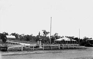
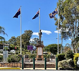
The Kenmore War Memorial was built to remember soldiers from the Shire of Moggill. It was first shown to the public on 3 July 1920. The memorial has been moved a few times due to roadworks. It is now in a special park called Pike Place.
In the early 1950s, a company called Hooker's bought dairy land. This started the modern growth of Kenmore. Roads were improved in 1960. Our Lady of the Rosary School opened in 1961. Earthworks for the first shopping centre began in the 1960s.
Kenmore South State School opened on 23 January 1967. Kenmore State High School opened on 24 January 1972. Over the years, important services like the ambulance centre (1972), fire station (1975), and police station (1978) also opened.
Kenmore was partly affected by the big 2010–11 Queensland floods. The Kenmore Library opened in 2010 as part of the Kenmore Village shopping centre.
Who Lives in Kenmore?
In 2021 census, Kenmore had a population of 9,675 people. Slightly more than half (51.2%) were female, and 48.8% were male. The average age of people in Kenmore was 40 years old.
Most people (65.2%) living in Kenmore were born in Australia. Other common birthplaces included England (5.2%), South Africa (3.7%), China (2.9%), New Zealand (2.4%), and India (2%). Most people (79.1%) spoke only English at home. Other languages spoken included Mandarin (4.1%), Korean (1.5%), and Cantonese (1%).
Important Historical Places
Kenmore has a few sites that are listed for their historical importance:
- 9A Brookfield Road: Kenmore War Memorial
- 6 Acworth Street: Kenmore Park homestead
- 982 Moggill Road: Former Kenmore Presbyterian Church (also known as Kenmore Uniting Church)
Learning in Kenmore
Kenmore has several schools for different age groups:
- Kenmore State School is a government primary school for students from Prep to Year 6. It is located at 2052 Moggill Road. In 2021, it had 403 students.
- Kenmore South State School is another government primary school for Prep to Year 6 students. It is at 16 Kersley Road. In 2021, it had 712 students.
- Our Lady of the Rosary School is a Catholic primary school for Prep to Year 6. You can find it at 1 Kenmore Road. In 2021, it had 390 students.
- Kenmore State High School is a government secondary school for students from Year 7 to Year 12. It is located at 60 Aberfeldy Street. In 2021, it had 1,967 students.
All these schools offer special education programs.
Shopping and Community Spots
Kenmore has two main shopping centres:
- Kenmore Village Shopping Centre is at the corner of Moggill Road and Brookfield Road. It also has offices.
- Kenmore Plaza Shopping Centre is on Moggill Road, across from Marshall Lane.
The Brisbane City Council runs a public library inside the Kenmore Village Shopping Centre.
There are also several churches in Kenmore:
- Our Lady of the Rosary Catholic Church, 1 Kenmore Road
- Holy Spirit Anglican Church, 1036 Moggill Road
- Kenmore Uniting Church, 982 Moggill Road
- Kenmore Church of Christ, 41 Brookfield Road
- Kenmore Presbyterian Church, which meets at Kenmore South State School
- Fuel Christian Church, 57a Kenmore Road
Sports and Outdoor Fun
Kenmore has many parks and sports fields. It's easy to get to outdoor activities in nearby suburbs. These include walking tracks and roads to the Mt Coot-tha lookout, Brisbane Botanic Gardens, and the planetarium. You can also find boating ramps for the Brisbane River and horse riding places in Fig Tree Pocket and Brookfield.
There are many places for sports in Kenmore. Akuna Oval is the largest. It has areas for soccer, AFL, and rugby. It also has many walking tracks. You can also rent tennis courts at Kenmore Primary School.
Community classes like yoga, fencing, and pilates are often held in Kenmore. There are also gyms like Curves International and Jett's Gym.
Active sports groups include the Kenmore Australian Football Club, Gem Road Park Soccer Association, Kenmore Lions Football Club, and Kenmore Centenary Bears Rugby Union.
Community Groups
Kenmore is crossed by Moggill Creek. The Moggill Creek Catchment Group helps keep the creek area clean. They also remove plants that don't belong there.
The Rotary Club of Kenmore is a group that helps the community. It is open to everyone, no matter their background.
The Kenmore branch of the Queensland Country Women's Association meets at the Kenmore Library.
The Kenmore and District Historical Society studies the history of Kenmore and the areas around it.
Getting Around Kenmore
Kenmore is well connected to the city and the University of Queensland by roads and buses.
The main road through Kenmore is Moggill Road. The main shopping area is around the roundabout where Brookfield and Moggill Roads meet. Another transport spot is at the Kenmore Tavern complex.
A new road called the Kenmore Bypass has been suggested. It would help with traffic on Moggill Road. However, many local residents are against it. They worry about homes being taken, losing local charm, and the disruption of building a big new road.
There is no train station in Kenmore. The closest one is Indooroopilly railway station.
 | Mary Eliza Mahoney |
 | Susie King Taylor |
 | Ida Gray |
 | Eliza Ann Grier |


