Kenmore Hills, Queensland facts for kids
Quick facts for kids Kenmore HillsBrisbane, Queensland |
|||||||||||||||
|---|---|---|---|---|---|---|---|---|---|---|---|---|---|---|---|

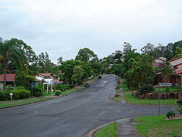
Mirbelia Street
|
|||||||||||||||
| Population | 2,448 (2021 census) | ||||||||||||||
| • Density | 521/km2 (1,350/sq mi) | ||||||||||||||
| Established | 1975 | ||||||||||||||
| Postcode(s) | 4069 | ||||||||||||||
| Area | 4.7 km2 (1.8 sq mi) | ||||||||||||||
| Time zone | AEST (UTC+10:00) | ||||||||||||||
| Location | 14.6 km (9 mi) WSW of Brisbane CBD | ||||||||||||||
| LGA(s) | City of Brisbane (Pullenvale Ward) |
||||||||||||||
| State electorate(s) | Moggill | ||||||||||||||
| Federal Division(s) | Ryan | ||||||||||||||
|
|||||||||||||||
Kenmore Hills is a lovely suburb located in the big city of Brisbane, Queensland, Australia. It's a place where about 2,448 people live, according to the 2021 census.
Contents
Exploring Kenmore Hills' Location
Kenmore Hills is about 13 kilometers (that's about 8 miles) by road from the very center of Brisbane. It's a peaceful area with some interesting natural features.
What is Carver Hill?
Even though part of Kenmore Hills is near the famous Mount Coot-tha, there's only one special hill inside the suburb itself. It's called Carver Hill, and it's about 70 meters (or 230 feet) above sea level.
A Look Back at Kenmore Hills' Past
Kenmore Hills has an interesting history, changing its name and purpose over the years.
How Did Kenmore Hills Get Its Name?
Originally, this area was part of another suburb called Brookfield. But in 1969, the name was changed to Kenmore Hills. This new name was chosen because it's right next to the suburb of Kenmore.
The Story of the Old Friary
A long time ago, in 1932, a special house at 139 Brookfield Road was bought by a church leader named Father Robert Bartlett Bates. He wanted to create a home for older men called St John's Home for Aged Men. This home later moved to another area.
A few years later, in 1934, the Anglican Church opened St Christopher's Lodge. This was a home and farm school for boys. It was a place where boys could live and learn until about 1959.
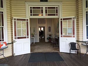
Later, part of this land was sold to the Presbyterian Church (which is now called the Uniting Church in Australia). They wanted to build a center for older people. The site was also used by a religious group called the Society of Saint Francis for quiet reflection and community activities. This special place is now protected on the Brisbane Heritage Register because of its history. In 2019, the Anglican Church sold the site to the Uniting Church, but with an agreement that the community could still use it.
Who Lives in Kenmore Hills?
Let's look at the people who call Kenmore Hills home.
Population Changes Over Time
- In 2011, about 2,577 people lived in Kenmore Hills.
- By 2016, the population was around 2,402 people.
- In the most recent count in 2021, Kenmore Hills had a population of 2,448 people.
A Diverse Community
The people living in Kenmore Hills come from many different backgrounds. While most residents were born in Australia, many others have come from countries like England, South Africa, New Zealand, and India. This mix of cultures makes Kenmore Hills a vibrant place!
Important Historical Places
Some buildings in Kenmore Hills are very old and important, so they are protected.
- 139 Brookfield Road: This is the Old Friary Complex, also known as the Brookfield Centre for Christian Spirituality. It's the historic site we talked about earlier, where the boys' home and aged care center once were.
Learning in Kenmore Hills
There are no schools directly inside Kenmore Hills. However, students can easily go to schools in the nearby suburbs.
Nearby Schools for Students
- Primary Schools: For younger students, there are schools like Chapel Hill State School in Chapel Hill, Kenmore State School in Kenmore, and Brookfield State School in Brookfield.
- Secondary Schools: Older students attend Kenmore State High School, which is located in the neighboring suburb of Kenmore.
 | Kyle Baker |
 | Joseph Yoakum |
 | Laura Wheeler Waring |
 | Henry Ossawa Tanner |


