Pullenvale, Queensland facts for kids
Quick facts for kids PullenvaleBrisbane, Queensland |
|||||||||||||||
|---|---|---|---|---|---|---|---|---|---|---|---|---|---|---|---|

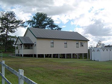
Pullenvale Hall, 2012
|
|||||||||||||||
| Population | 3,276 (2021 census) | ||||||||||||||
| • Density | 169.7/km2 (440/sq mi) | ||||||||||||||
| Postcode(s) | 4069 | ||||||||||||||
| Area | 19.3 km2 (7.5 sq mi) | ||||||||||||||
| Time zone | AEST (UTC+10:00) | ||||||||||||||
| Location | 19.3 km (12 mi) SW of Brisbane CBD | ||||||||||||||
| LGA(s) | City of Brisbane (Pullenvale Ward) |
||||||||||||||
| State electorate(s) | Moggill | ||||||||||||||
| Federal Division(s) | Ryan | ||||||||||||||
|
|||||||||||||||
Pullenvale is a suburb located west of Brisbane, in Queensland, Australia. It is part of the City of Brisbane. In 2021, about 3,276 people lived there.
Contents
Exploring Pullenvale's Landscape
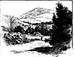
Mount Elphinstone is a hill in the north of Pullenvale. It stands about 211 meters (692 feet) tall.
Pullenvale is about 19.3 kilometers (12 miles) southwest of Brisbane CBD by road. The area has rolling hills and lots of bushland. It covers about 19.3 square kilometers (7.5 square miles). Most of the land is used for homes with large yards, like a rural neighborhood.
Pullenvale's Past: A Journey Through Time
How Pullenvale Got Its Name
In 1827, a botanist and explorer named Allan Cunningham named Mount Elphinstone. He first called it Mount Halsey.
The name Pullenvale has a few interesting stories. One idea from the 1920s is that it was named after an early timber cutter, George Pullen. However, there are no land records to prove this.
The local creek is called Pullen Pullen Creek. Some people think the repeated name comes from an Aboriginal language. It might mean "to die" or "fighting ground." Another idea is that Pullen Pullen was originally "Bullen Bullen," an Aboriginal word meaning "lonely place."
An old newspaper from 1850 supports the "fighting" idea. It described a big "Pullen-Pullen" gathering near Brisbane. Aboriginal groups from different areas attended. Some people got spear wounds, but no one died.
The name Glen Pullen was used before Pullenvale. In 1873, Pullenvale was called a "new name." There was even a "Glenpullen Farm" in Pullenvale that year.
Early Industries and Growth
The first people to settle in Pullenvale started a logging industry. The building of Moggill Road helped connect the area to Brisbane and Ipswich. This made it easier to get around. Later, logging changed to small crop farming and dairy farming.
Pullenvale Cemetery's History
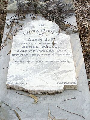
In 1873, a 10-acre area was set aside for a cemetery. Eight burials happened there between 1876 and 1888. Today, only one headstone remains for Adam James Furley Walker.
When Greater Brisbane was formed in 1925, the Brisbane City Council took over the cemetery. They closed it in 1930. Most of the land was sold, except for the small area with the graves.
Education in Pullenvale
The small number of farming families led to the creation of Pullenvale State School. It opened on March 16, 1874, with 32 students. Residents worked hard to raise money for the school.
In 1873, a newspaper noted that Pullenvale residents had "considerable pluck." They saved £60 to help build a school. A year later, it was reported that there was a "fine school and teacher's residence."
The school was rebuilt in 1981 on Grandview Road. This was to handle the growing population from Brisbane. In 2015, the school became an Independent Public School.
Brisbane Independent School opened in 1968 in St Lucia. Parents wanted a different type of education for their children. They wanted a place where kids could explore their creativity. The school moved to Pullenvale in 1972 on land given by the Job family.
Community Buildings and Clubs
Pullenvale Hall used to be a pineapple packing shed. It was bought in 1943 from a resident named Jack Woodward. Today, the Pullenvale Progress Association uses it for many community events and classes.
Moggill Pony Club started in April 1961. It is one of the oldest pony clubs in Queensland. It is located on 4 hectares (10 acres) of land in Pullenvale.
Pullenvale's Population Over Time
In 2011, Pullenvale had 3,174 people. About 49.8% were female and 50.2% were male. The average age was 39 years, which was two years older than the Australian average.
Most people (68.2%) in Pullenvale were born in Australia. Other common birthplaces included England (10.3%), South Africa (4.6%), and New Zealand (2.4%). Most people (91.2%) spoke only English at home.
In 2016, the population was 3,179 people. By 2021, Pullenvale's population grew to 3,276 people.
Places of Historical Importance
Pullenvale has a few sites listed for their historical importance:
- Pullenvale Cemetery at 243A Haven Road (27°30′06″S 152°53′33″E / 27.5017°S 152.8926°E)
Science and Technology in Pullenvale
The CSIRO (Commonwealth Scientific and Industrial Research Organisation) has a big research center here. It's called the Queensland Centre for Advanced Technologies (QCAT). It is located at 1 Technology Drive.
QCAT is a research and development area for industries like mining and advanced technology. Part of the campus also extends into the nearby area of Pinjarra Hills.
Schools in Pullenvale
Pullenvale has two primary schools:
- Pullenvale State School is a government primary school for students from Prep to Year 6. It is located at 120 Grandview Road (27°31′57″S 152°53′43″E / 27.5326°S 152.8953°E). In 2018, it had 437 students.
- Brisbane Independent School is a private primary school for students from Prep to Year 6. It is located at 2447 Moggill Road (27°31′27″S 152°55′07″E / 27.5241°S 152.9187°E). In 2018, it had 86 students.
Pullenvale also has an Outdoor and Environmental Education Centre. It is at 250 Grandview Road (27°31′33″S 152°53′19″E / 27.5258°S 152.8886°E). This center is on the old site of Pullenvale State School, and the old school building is still there.
There are no high schools in Pullenvale. The closest government high school is Kenmore State High School in Kenmore.
Important Facilities
Pullenvale Fire Station is located at 6 Pullenvale Road (27°31′17″S 152°55′17″E / 27.5213°S 152.9214°E). This station helps keep the community safe.
Local Amenities and Parks
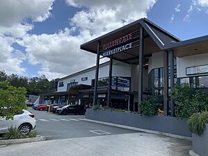
Pullenvale Marketplace is a shopping center at 8 McCaskill Road (27°31′47″S 152°54′35″E / 27.5297°S 152.9098°E). It has an IGA supermarket and other shops.
Pullenvale Hall is at 302 Grandview Road (27°31′25″S 152°53′11″E / 27.5236°S 152.8863°E). It is a busy place for community events and classes.
The Moggill Pony Club is on O'Brien Road in Pullenvale (27°32′14″S 152°53′13″E / 27.5372°S 152.8869°E). It provides a place for horse riding and activities.
Pullenvale has many parks for outdoor fun:
- Airlie Road Park (27°31′58″S 152°53′32″E / 27.5327°S 152.8922°E)
- Grandview Road Park (27°31′53″S 152°53′48″E / 27.5315°S 152.8967°E)
- Lancing Street Park (27°32′14″S 152°53′30″E / 27.5372°S 152.8917°E)
- Mccaskill Road Park (27°31′49″S 152°54′31″E / 27.5302°S 152.9085°E)
- Primley Street Park (27°31′47″S 152°52′14″E / 27.5298°S 152.8706°E)
- Pullenvale Forest Park (27°31′29″S 152°53′33″E / 27.5248°S 152.8926°E)
- Pullenvale Recreation Reserve (27°31′12″S 152°55′12″E / 27.5201°S 152.9199°E)
- Woodward Place Park (27°31′20″S 152°52′50″E / 27.5221°S 152.8806°E)
 | Claudette Colvin |
 | Myrlie Evers-Williams |
 | Alberta Odell Jones |


